Tynne elevation
Tynne (Rivne), Ukraine elevation is 216 meters and Tynne elevation in feet is 709 ft above sea level [src 1]. Tynne is a populated place (feature code) with elevation that is 59 meters (194 ft) bigger than average city elevation in Ukraine.
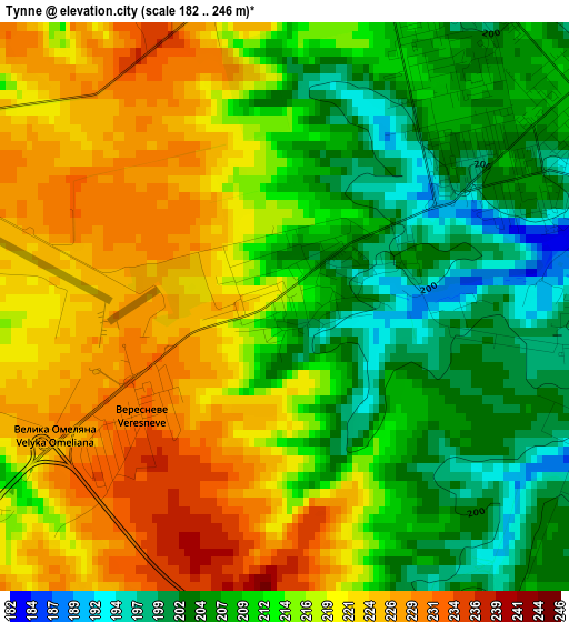
Below is the Elevation map of Tynne, which displays elevation range with different colors. Scale of the first map is from 182 to 246 m (597 to 807 ft) with average elevation of 214.6 meters (=704 ft) [note 1]
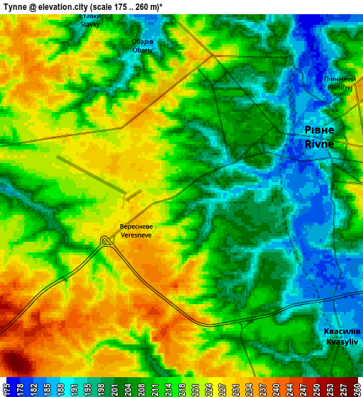
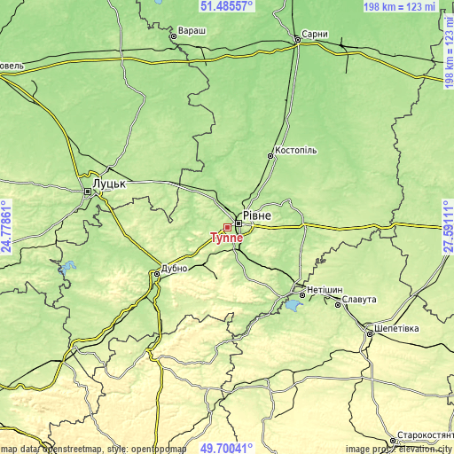
These maps also provides idea of topography and contour of this city, they are displayed at different zoom levels. More info about maps, scale and edge coordinates you can find below images.
| \ | Map #1 | Map #2 | Topo.Map |
| Scale [m] | 182..246 m | 175..260 m | × |
| Scale [ft] | 597..807 ft | 574..853 ft | × |
| Average | 214.6 m = 704 ft | 212.6 m = 698 ft | × |
| Width | 6.2 km = 3.9 mi | 12.41 km = 7.7 mi | 198.5 km = 123.3 mi |
| Height | 6.2 km = 3.9 mi | 12.41 km = 7.7 mi | 198.5 km = 123.3 mi |
| ↑Max Latitude | 50.629334° | 50.657202° | 51.48557° |
| Latitude at center | 50.60145° | 50.60145° | 50.60145° |
| ↓Min Latitude | 50.573549° | 50.545632° | 49.70041° |
| ← Min Longitude | 26.140915° | 26.096969° | 24.77861° |
| Longitude center | 26.18486° | 26.18486° | 26.18486° |
| →Max Longitude | 26.228805° | 26.272751° | 27.59111° |
Nearby cities:
Cities around Tynne sort by population:
• Rivne elevation 207 m
3.8 km,  51°
51°
• Dubno 199 m
37.9 km,  237°
237°
• Kostopil’ 182 m
36.1 km,  31°
31°
• Zdolbuniv 195 m
9.9 km,  155°
155°
• Hoshcha 199 m
34.5 km,  90°
90°
• Zdovbytsya 199 m
12.4 km, 161°
• Orzhiv 203 m
22.5 km,  348°
348°
• Horodyshche 209 m
13.4 km,  71°
71°
• Mizoch 257 m
22.5 km,  186°
186°
• Olyka 198 m
29.3 km,  296°
296°
• Kolodenka 215 m
9.4 km,  100°
100°
• Klevan 202 m
21.5 km,  316°
316°
Multilingual:
 En español:
Tynne elevación 216 m.
 En France:
Tynne élévation 216 m.


Sources and notes:
- [note 1] Map square and city borders are not equal. Map elevation data is calculated only from area inside that square.
- [src 1] Elevation data from geonames database provided with same terms of usage.
- [src 2] The elevation map of Tynne is generated using elevation data from NASA's 3 arcsec (90m) resolution SRTM data.
- [src 3] Base (background) map © OpenStreetMap contributors tiles are generated by Geofabrik and OpenTopoMap.
Copyright & License:
This Tynne Elevation Map is licensed under CC BY-SA. You may reuse any part from this page, if you give a proper credit by linking to this URL:
 More info on terms of use page.