Uvarovo elevation
Uvarovo (Republic of Crimea, Lenine Raion), Ukraine elevation is 24 meters and Uvarovo elevation in feet is 79 ft above sea level [src 1]. Uvarovo is a seat of a third-order administrative division (feature code) with elevation that is 133 meters (436 ft) smaller than average city elevation in Ukraine.
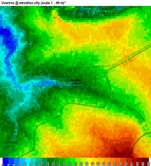
Below is the Elevation map of Uvarovo, which displays elevation range with different colors. Scale of the first map is from 1 to 69 m (3 to 226 ft) with average elevation of 33.2 meters (=109 ft) [note 1]
These maps also provides idea of topography and contour of this city, they are displayed at different zoom levels. More info about maps, scale and edge coordinates you can find below images.
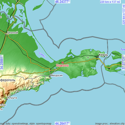
| \ | Map #1 | Topo.Map |
| Scale [m] | 1..69 m | × |
| Scale [ft] | 3..226 ft | × |
| Average | 33.2 m = 109 ft | × |
| Width | 6.88 km = 4.3 mi | 220.1 km = 136.8 mi |
| Height | 6.88 km = 4.3 mi | 220.1 km = 136.8 mi |
| ↑Max Latitude | 45.293523° | 46.24377° |
| Latitude at center | 45.2626° | 45.2626° |
| ↓Min Latitude | 45.23166° | 44.26417° |
| ← Min Longitude | 35.621115° | 34.25881° |
| Longitude center | 35.66506° | 35.66506° |
| →Max Longitude | 35.709005° | 37.07131° |
Nearby cities:
Cities around Uvarovo sort by population:
• Primorskiy elevation 14 m
21.6 km,  222°
222°
• Lenino 22 m
9.6 km,  65°
65°
• Kalinovka 15 m
8.7 km,  46°
46°
• Ilychyovo 35 m
6.2 km, 68°
• Leninskoye 37 m
20 km,  92°
92°
• Semisotka 26 m
8 km,  257°
257°
• Ostanino 20 m
20.7 km, 69°
• Batal’noye 61 m
8.5 km,  206°
206°
• Vinogradnoye 35 m
14.4 km,  76°
76°
• Lugovoye 47 m
5.4 km,  124°
124°
• Krasnogorka 52 m
11.3 km,  99°
99°
• Kirovo 84 m
14.6 km,  108°
108°
Multilingual:
 En español:
Uvarovo elevación 24 m.
 En France:
Uvarovo élévation 24 m.


Sources and notes:
- [note 1] Map square and city borders are not equal. Map elevation data is calculated only from area inside that square.
- [src 1] Elevation data from geonames database provided with same terms of usage.
- [src 2] The elevation map of Uvarovo is generated using elevation data from NASA's 3 arcsec (90m) resolution SRTM data.
- [src 3] Base (background) map © OpenStreetMap contributors tiles are generated by Geofabrik and OpenTopoMap.
Copyright & License:
This Uvarovo Elevation Map is licensed under CC BY-SA. You may reuse any part from this page, if you give a proper credit by linking to this URL:
 More info on terms of use page.