Zhvanets elevation
Zhvanets (Khmelnytskyi), Ukraine elevation is 159 meters and Zhvanets elevation in feet is 522 ft above sea level [src 1]. Zhvanets is a populated place (feature code) with elevation that is 2 meters (7 ft) bigger than average city elevation in Ukraine.
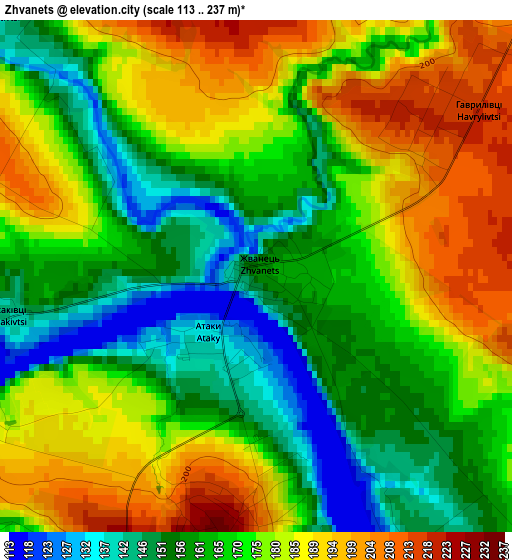
Below is the Elevation map of Zhvanets, which displays elevation range with different colors. Scale of the first map is from 113 to 237 m (371 to 778 ft) with average elevation of 172 meters (=564 ft) [note 1]
These maps also provides idea of topography and contour of this city, they are displayed at different zoom levels. More info about maps, scale and edge coordinates you can find below images.
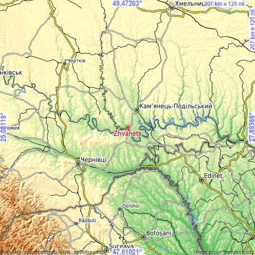
| \ | Map #1 | Topo.Map |
| Scale [m] | 113..237 m | × |
| Scale [ft] | 371..778 ft | × |
| Average | 172 m = 564 ft | × |
| Width | 6.47 km = 4 mi | 207 km = 128.6 mi |
| Height | 6.47 km = 4 mi | 207 km = 128.6 mi |
| ↑Max Latitude | 48.578762° | 49.47203° |
| Latitude at center | 48.54968° | 48.54968° |
| ↓Min Latitude | 48.520581° | 47.61021° |
| ← Min Longitude | 26.443495° | 25.08119° |
| Longitude center | 26.48744° | 26.48744° |
| →Max Longitude | 26.531385° | 27.89369° |
Nearby cities:
Cities around Zhvanets sort by population:
• Kamianets-Podilskyi elevation 227 m
16.6 km,  25°
25°
• Dunaivtsi 320 m
46.4 km,  35°
35°
• Borshchiv 253 m
43.1 km,  310°
310°
• Khotyn 244 m
4.8 km,  176°
176°
• Novoselytsya 139 m
40.2 km,  204°
204°
• Klishkivtsi 266 m
21.2 km,  231°
231°
• Makiv 266 m
31.1 km, 28°
• Marshintsy 134 m
39.7 km, 201°
• Boyany 163 m
40.9 km,  220°
220°
• Skala-Podil’s’ka 246 m
39.7 km,  327°
327°
• Smotrych 213 m
13.5 km,  23°
23°
• Kel’mentsi 205 m
27.2 km,  110°
110°
Multilingual:
 En español:
Zhvanets elevación 159 m.
 En France:
Zhvanets élévation 159 m.
 Auf Deutsch:
Zhvanets höhe über dem Meeresspiegel ist 159 m.

Sources and notes:
- [note 1] Map square and city borders are not equal. Map elevation data is calculated only from area inside that square.
- [src 1] Elevation data from geonames database provided with same terms of usage.
- [src 2] The elevation map of Zhvanets is generated using elevation data from NASA's 3 arcsec (90m) resolution SRTM data.
- [src 3] Base (background) map © OpenStreetMap contributors tiles are generated by Geofabrik and OpenTopoMap.
Copyright & License:
This Zhvanets Elevation Map is licensed under CC BY-SA. You may reuse any part from this page, if you give a proper credit by linking to this URL:
 More info on terms of use page.