Zimino elevation
Zimino (Republic of Crimea, Razdol’nenskiy rayon), Ukraine elevation is 53 meters and Zimino elevation in feet is 174 ft above sea level [src 1]. Zimino is a seat of a third-order administrative division (feature code) with elevation that is 104 meters (341 ft) smaller than average city elevation in Ukraine.
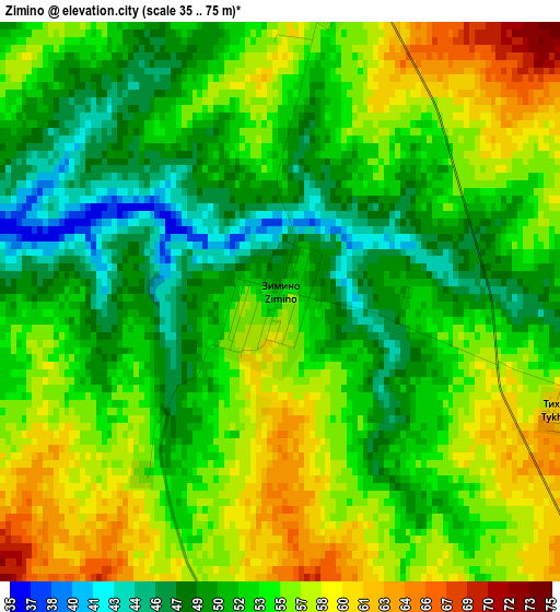
Below is the Elevation map of Zimino, which displays elevation range with different colors. Scale of the first map is from 35 to 75 m (115 to 246 ft) with average elevation of 53.5 meters (=176 ft) [note 1]
These maps also provides idea of topography and contour of this city, they are displayed at different zoom levels. More info about maps, scale and edge coordinates you can find below images.
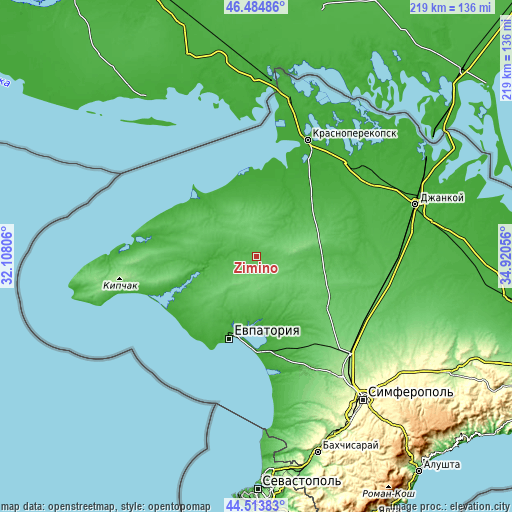
| \ | Map #1 | Topo.Map |
| Scale [m] | 35..75 m | × |
| Scale [ft] | 115..246 ft | × |
| Average | 53.5 m = 176 ft | × |
| Width | 6.85 km = 4.3 mi | 219.2 km = 136.2 mi |
| Height | 6.85 km = 4.3 mi | 219.1 km = 136.1 mi |
| ↑Max Latitude | 45.538759° | 46.48486° |
| Latitude at center | 45.50797° | 45.50797° |
| ↓Min Latitude | 45.477164° | 44.51383° |
| ← Min Longitude | 33.470365° | 32.10806° |
| Longitude center | 33.51431° | 33.51431° |
| →Max Longitude | 33.558255° | 34.92056° |
Nearby cities:
Cities around Zimino sort by population:
• Novoselovskoye elevation 86 m
9.8 km,  138°
138°
• Kormovoye 66 m
7.7 km,  96°
96°
• Berezovka 52 m
15.2 km,  299°
299°
• Dobrushino 66 m
18.9 km,  218°
218°
• Stolbovoye 94 m
16.2 km,  185°
185°
• Alekseyevka 69 m
12.2 km,  47°
47°
• Vinogradovo 84 m
16.5 km, 141°
• Serebryanka 95 m
14.7 km,  354°
354°
• Susanino 71 m
14.4 km,  93°
93°
• Kovyl’noye 72 m
20.3 km,  2°
2°
• Kol’tsovo 67 m
20.6 km, 194°
• Krasnoyarskoye 21 m
19.3 km,  269°
269°
Multilingual:
 En español:
Zimino elevación 53 m.
 En France:
Zimino élévation 53 m.


Sources and notes:
- [note 1] Map square and city borders are not equal. Map elevation data is calculated only from area inside that square.
- [src 1] Elevation data from geonames database provided with same terms of usage.
- [src 2] The elevation map of Zimino is generated using elevation data from NASA's 3 arcsec (90m) resolution SRTM data.
- [src 3] Base (background) map © OpenStreetMap contributors tiles are generated by Geofabrik and OpenTopoMap.
Copyright & License:
This Zimino Elevation Map is licensed under CC BY-SA. You may reuse any part from this page, if you give a proper credit by linking to this URL:
 More info on terms of use page.