Zmiyiv elevation
Zmiyiv (Kharkiv), Ukraine elevation is 93 meters and Zmiyiv elevation in feet is 305 ft above sea level [src 1]. Zmiyiv is a seat of a second-order administrative division (feature code) with elevation that is 64 meters (210 ft) smaller than average city elevation in Ukraine.
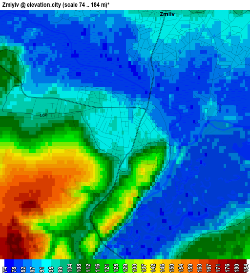
Below is the Elevation map of Zmiyiv, which displays elevation range with different colors. Scale of the first map is from 74 to 184 m (243 to 604 ft) with average elevation of 100.9 meters (=331 ft) [note 1]
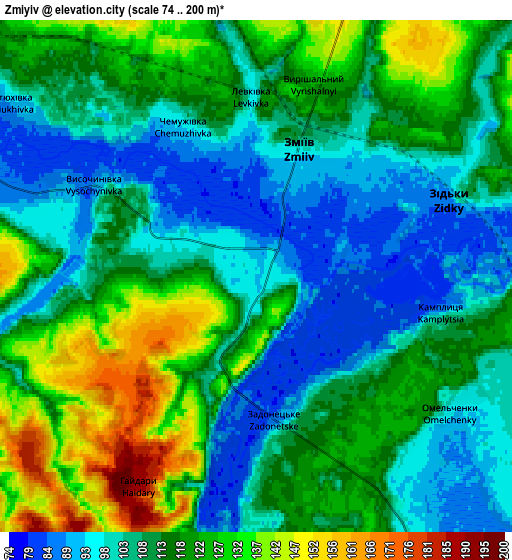
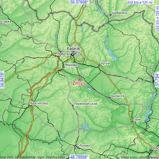
These maps also provides idea of topography and contour of this city, they are displayed at different zoom levels. More info about maps, scale and edge coordinates you can find below images.
| \ | Map #1 | Map #2 | Topo.Map |
| Scale [m] | 74..184 m | 74..200 m | × |
| Scale [ft] | 243..604 ft | 243..656 ft | × |
| Average | 100.9 m = 331 ft | 112.6 m = 369 ft | × |
| Width | 6.32 km = 3.9 mi | 12.65 km = 7.9 mi | 202.4 km = 125.8 mi |
| Height | 6.32 km = 3.9 mi | 12.65 km = 7.9 mi | 202.4 km = 125.8 mi |
| ↑Max Latitude | 49.70296° | 49.731373° | 50.57606° |
| Latitude at center | 49.67453° | 49.67453° | 49.67453° |
| ↓Min Latitude | 49.646083° | 49.61762° | 48.75598° |
| ← Min Longitude | 36.303805° | 36.259859° | 34.9415° |
| Longitude center | 36.34775° | 36.34775° | 36.34775° |
| →Max Longitude | 36.391695° | 36.435641° | 37.754° |
Nearby cities:
Cities around Zmiyiv sort by population:
• Merefa elevation 102 m
27 km,  307°
307°
• Slobozhans’ke 99 m
15.5 km,  123°
123°
• Vysokyy 154 m
29.1 km,  326°
326°
• Pokotylivka 153 m
29.3 km, 334°
• Bezlyudivka 105 m
23.1 km,  345°
345°
• Vasyshcheve 94 m
17.2 km,  355°
355°
• Eskhar 120 m
22.1 km,  52°
52°
• Novopokrovka 96 m
22.8 km,  39°
39°
• Khorosheve 127 m
22.1 km, 334°
• Lyman 94 m
12.3 km,  134°
134°
• Vvedenka 97 m
20 km,  33°
33°
• Utkivka 98 m
23.2 km,  302°
302°
Multilingual:
 En español:
Zmiyiv elevación 93 m.
 En France:
Zmiyiv élévation 93 m.


Sources and notes:
- [note 1] Map square and city borders are not equal. Map elevation data is calculated only from area inside that square.
- [src 1] Elevation data from geonames database provided with same terms of usage.
- [src 2] The elevation map of Zmiyiv is generated using elevation data from NASA's 3 arcsec (90m) resolution SRTM data.
- [src 3] Base (background) map © OpenStreetMap contributors tiles are generated by Geofabrik and OpenTopoMap.
Copyright & License:
This Zmiyiv Elevation Map is licensed under CC BY-SA. You may reuse any part from this page, if you give a proper credit by linking to this URL:
 More info on terms of use page.