Zernovoye elevation
Zernovoye (Republic of Crimea, Sakskiy rayon), Ukraine elevation is 85 meters and Zernovoye elevation in feet is 279 ft above sea level [src 1]. Zernovoye is a seat of a third-order administrative division (feature code) with elevation that is 72 meters (236 ft) smaller than average city elevation in Ukraine.
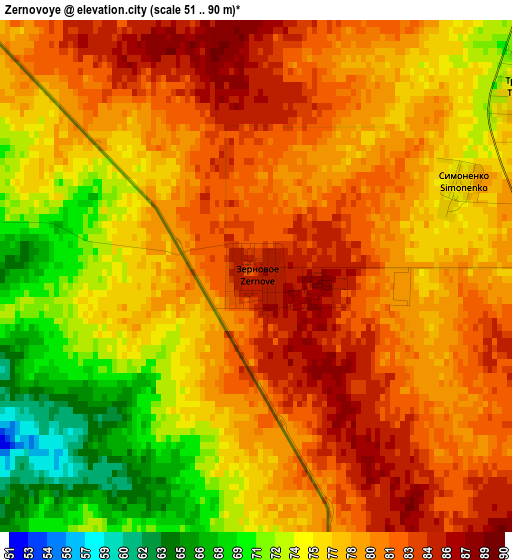
Below is the Elevation map of Zernovoye, which displays elevation range with different colors. Scale of the first map is from 51 to 90 m (167 to 295 ft) with average elevation of 77.4 meters (=254 ft) [note 1]
These maps also provides idea of topography and contour of this city, they are displayed at different zoom levels. More info about maps, scale and edge coordinates you can find below images.
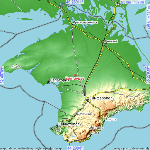
| \ | Map #1 | Topo.Map |
| Scale [m] | 51..90 m | × |
| Scale [ft] | 167..295 ft | × |
| Average | 77.4 m = 254 ft | × |
| Width | 6.88 km = 4.3 mi | 220 km = 136.7 mi |
| Height | 6.88 km = 4.3 mi | 220 km = 136.7 mi |
| ↑Max Latitude | 45.319289° | 46.26911° |
| Latitude at center | 45.28838° | 45.28838° |
| ↓Min Latitude | 45.257454° | 44.2904° |
| ← Min Longitude | 33.820195° | 32.45789° |
| Longitude center | 33.86414° | 33.86414° |
| →Max Longitude | 33.908085° | 35.27039° |
Nearby cities:
Cities around Zernovoye sort by population:
• Mityayevo elevation 29 m
14.1 km,  244°
244°
• Krymskoye 69 m
12.2 km,  203°
203°
• Sizovka 72 m
6.8 km,  8°
8°
• Leninskoye 87 m
14.7 km,  98°
98°
• Shirokoye 112 m
17.6 km,  123°
123°
• Trudovoye 23 m
10 km, 235°
• Kotel’nikovo 68 m
15.3 km,  55°
55°
• Zhuravlyovka 116 m
16.2 km,  140°
140°
• Shelkovichnoye 37 m
17.8 km,  230°
230°
• Krasnoznamenka 85 m
10.7 km,  90°
90°
• Krayneye 45 m
7 km, 200°
• Stakhanovka 67 m
11.3 km,  35°
35°
Multilingual:
 En español:
Zernovoye elevación 85 m.
 En France:
Zernovoye élévation 85 m.
 Auf Deutsch:
Zernovoye höhe über dem Meeresspiegel ist 85 m.

Sources and notes:
- [note 1] Map square and city borders are not equal. Map elevation data is calculated only from area inside that square.
- [src 1] Elevation data from geonames database provided with same terms of usage.
- [src 2] The elevation map of Zernovoye is generated using elevation data from NASA's 3 arcsec (90m) resolution SRTM data.
- [src 3] Base (background) map © OpenStreetMap contributors tiles are generated by Geofabrik and OpenTopoMap.
Copyright & License:
This Zernovoye Elevation Map is licensed under CC BY-SA. You may reuse any part from this page, if you give a proper credit by linking to this URL:
 More info on terms of use page.