Namikupa elevation
Namikupa (Mtwara, Tandahimba), Tanzania elevation is 276 meters and Namikupa elevation in feet is 906 ft above sea level [src 1]. Namikupa is a populated place (feature code) with elevation that is 667 meters (2188 ft) smaller than average city elevation in Tanzania.
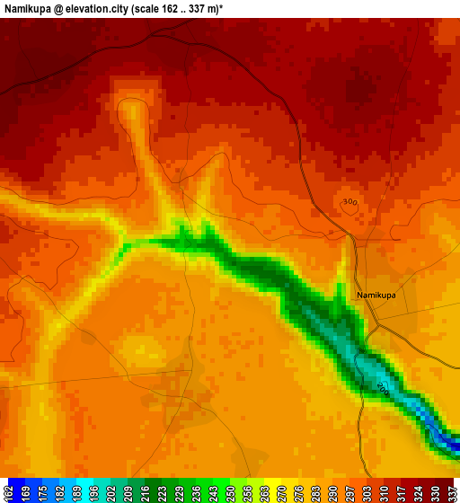
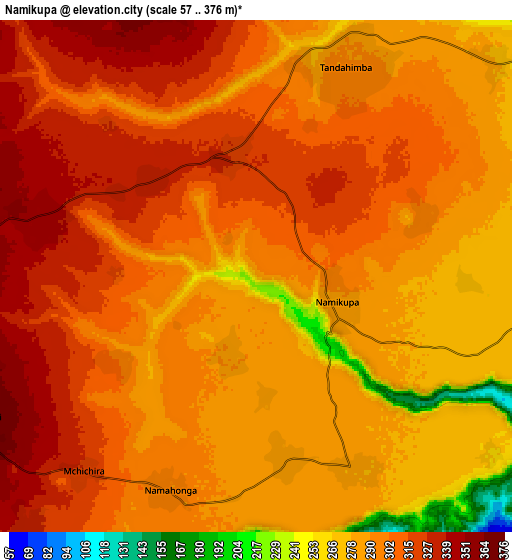
Below is the Elevation map of Namikupa, which displays elevation range with different colors. Scale of the first map is from 162 to 337 m (531 to 1106 ft) with average elevation of 295.3 meters (=969 ft) [note 1]
These maps also provides idea of topography and contour of this city, they are displayed at different zoom levels. More info about maps, scale and edge coordinates you can find below images.
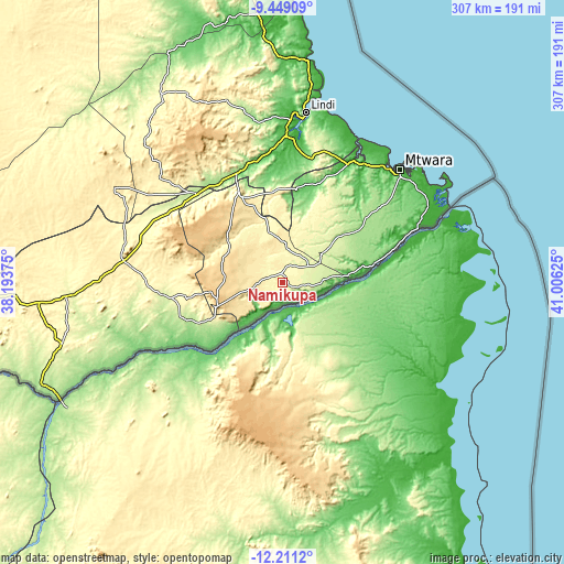
| \ | Map #1 | Map #2 | Topo.Map |
| Scale [m] | 162..337 m | 57..376 m | × |
| Scale [ft] | 531..1106 ft | 187..1234 ft | × |
| Average | 295.3 m = 969 ft | 298.2 m = 978 ft | × |
| Width | 9.6 km = 6 mi | 19.2 km = 11.9 mi | 307.1 km = 190.8 mi |
| Height | 9.6 km = 6 mi | 19.2 km = 11.9 mi | 307.1 km = 190.8 mi |
| ↑Max Latitude | -10.790165° | -10.746993° | -9.44909° |
| Latitude at center | -10.83333° | -10.83333° | -10.83333° |
| ↓Min Latitude | -10.876489° | -10.919642° | -12.2112° |
| ← Min Longitude | 39.556055° | 39.512109° | 38.19375° |
| Longitude center | 39.6° | 39.6° | 39.6° |
| →Max Longitude | 39.643945° | 39.687891° | 41.00625° |
Nearby cities:
Cities around Namikupa sort by population:
• Newala Kisimani elevation 687 m
36.9 km,  249°
249°
• Luchingu 607 m
30 km,  255°
255°
• Nanyamba 243 m
30.5 km,  56°
56°
• Tandahimba 284 m
10 km,  21°
21°
• Nyangao 182 m
65.5 km,  328°
328°
• Kitama 264 m
19.5 km,  48°
48°
• Mahuta 478 m
16.8 km, 257°
• Nanhyanga 338 m
6.6 km,  304°
304°
• Mtama 136 m
64.6 km,  336°
336°
• Namalenga 280 m
56.1 km, 256°
• Kitangari 468 m
35.6 km, 304°
• Lulindi 441 m
51 km,  272°
272°
Multilingual:
 En español:
Namikupa elevación 276 m.
 En France:
Namikupa élévation 276 m.
 Auf Deutsch:
Namikupa höhe über dem Meeresspiegel ist 276 m.

Sources and notes:
- [note 1] Map square and city borders are not equal. Map elevation data is calculated only from area inside that square.
- [src 1] Elevation data from geonames database provided with same terms of usage.
- [src 2] The elevation map of Namikupa is generated using elevation data from NASA's 3 arcsec (90m) resolution SRTM data.
- [src 3] Base (background) map © OpenStreetMap contributors tiles are generated by Geofabrik and OpenTopoMap.
Copyright & License:
This Namikupa Elevation Map is licensed under CC BY-SA. You may reuse any part from this page, if you give a proper credit by linking to this URL:
 More info on terms of use page.