Igunga elevation
Igunga (Tabora), Tanzania elevation is 1090 meters and Igunga elevation in feet is 3576 ft above sea level [src 1]. Igunga is a populated place (feature code) with elevation that is 147 meters (482 ft) bigger than average city elevation in Tanzania.
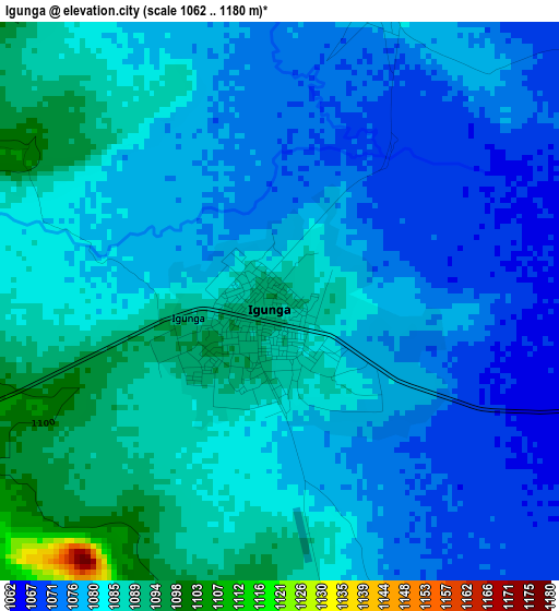
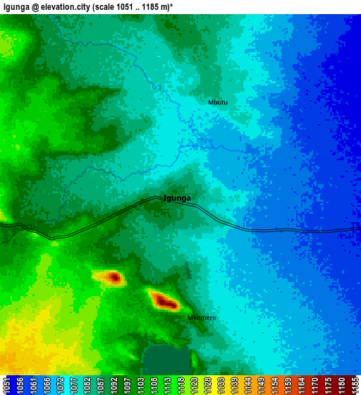
Below is the Elevation map of Igunga, which displays elevation range with different colors. Scale of the first map is from 1062 to 1180 m (3484 to 3871 ft) with average elevation of 1080.5 meters (=3545 ft) [note 1]
These maps also provides idea of topography and contour of this city, they are displayed at different zoom levels. More info about maps, scale and edge coordinates you can find below images.
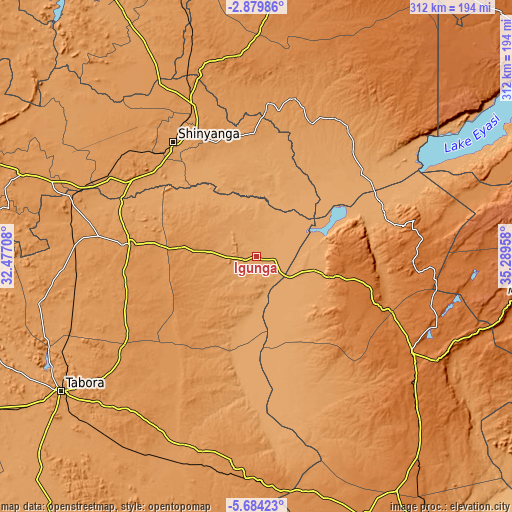
| \ | Map #1 | Map #2 | Topo.Map |
| Scale [m] | 1062..1180 m | 1051..1185 m | × |
| Scale [ft] | 3484..3871 ft | 3448..3888 ft | × |
| Average | 1080.5 m = 3545 ft | 1084.2 m = 3557 ft | × |
| Width | 9.75 km = 6.1 mi | 19.49 km = 12.1 mi | 311.8 km = 193.7 mi |
| Height | 9.75 km = 6.1 mi | 19.49 km = 12.1 mi | 311.8 km = 193.7 mi |
| ↑Max Latitude | -4.239506° | -4.19568° | -2.87986° |
| Latitude at center | -4.28333° | -4.28333° | -4.28333° |
| ↓Min Latitude | -4.327151° | -4.37097° | -5.68423° |
| ← Min Longitude | 33.839385° | 33.795439° | 32.47708° |
| Longitude center | 33.88333° | 33.88333° | 33.88333° |
| →Max Longitude | 33.927275° | 33.971221° | 35.28958° |
Nearby cities:
Cities around Igunga sort by population:
• Shinyanga elevation 1133 m
85.9 km,  323°
323°
• Nzega 1241 m
78 km,  275°
275°
• Sepuka 1484 m
88.8 km,  125°
125°
• Shelui 1091 m
36.3 km,  104°
104°
• Kiomboi 1545 m
53.6 km,  88°
88°
• Mwadui 1215 m
87.4 km,  338°
338°
• Igugunu 1376 m
88.9 km,  110°
110°
• Lalago 1176 m
93 km,  4°
4°
• Tinde 1154 m
87.9 km,  300°
300°
• Kishapu 1169 m
74.1 km,  358°
358°
• Ndago 1443 m
62.6 km,  124°
124°
• Igurubi 1087 m
37.5 km,  327°
327°
Multilingual:
 En español:
Igunga elevación 1090 m.
 En France:
Igunga élévation 1090 m.


Sources and notes:
- [note 1] Map square and city borders are not equal. Map elevation data is calculated only from area inside that square.
- [src 1] Elevation data from geonames database provided with same terms of usage.
- [src 2] The elevation map of Igunga is generated using elevation data from NASA's 3 arcsec (90m) resolution SRTM data.
- [src 3] Base (background) map © OpenStreetMap contributors tiles are generated by Geofabrik and OpenTopoMap.
Copyright & License:
This Igunga Elevation Map is licensed under CC BY-SA. You may reuse any part from this page, if you give a proper credit by linking to this URL:
 More info on terms of use page.