Mazinde elevation
Mazinde (Tanga, Korogwe District), Tanzania elevation is 485 meters and Mazinde elevation in feet is 1591 ft above sea level [src 1]. Mazinde is a populated place (feature code) with elevation that is 458 meters (1503 ft) smaller than average city elevation in Tanzania.
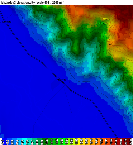
Below is the Elevation map of Mazinde, which displays elevation range with different colors. Scale of the first map is from 401 to 2246 m (1316 to 7369 ft) with average elevation of 731.6 meters (=2400 ft) [note 1]
These maps also provides idea of topography and contour of this city, they are displayed at different zoom levels. More info about maps, scale and edge coordinates you can find below images.
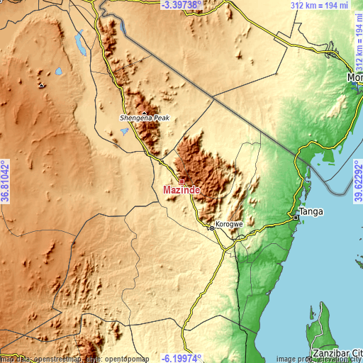
| \ | Map #1 | Map #2 | Topo.Map |
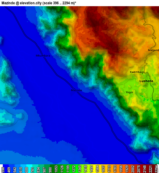
| Scale [m] | 401..2246 m | 396..2294 m | × |
| Scale [ft] | 1316..7369 ft | 1299..7526 ft | × |
| Average | 731.6 m = 2400 ft | 892 m = 2927 ft | × |
| Width | 9.74 km = 6.1 mi | 19.48 km = 12.1 mi | 311.6 km = 193.6 mi |
| Height | 9.74 km = 6.1 mi | 19.48 km = 12.1 mi | 311.6 km = 193.6 mi |
| ↑Max Latitude | -4.756207° | -4.712412° | -3.39738° |
| Latitude at center | -4.8° | -4.8° | -4.8° |
| ↓Min Latitude | -4.84379° | -4.887577° | -6.19974° |
| ← Min Longitude | 38.172725° | 38.128779° | 36.81042° |
| Longitude center | 38.21667° | 38.21667° | 38.21667° |
| →Max Longitude | 38.260615° | 38.304561° | 39.62292° |
Nearby cities:
Cities around Mazinde sort by population:
• Chanika elevation 673 m
72.1 km,  197°
197°
• Maramba 959 m
52.3 km,  122°
122°
• Lushoto 1498 m
7.6 km,  75°
75°
• Matui 908 m
3.7 km,  90°
90°
• Hedaru 640 m
48.4 km,  313°
313°
• Makuyuni 479 m
14.9 km,  299°
299°
• Ndungu 535 m
51.6 km,  339°
339°
• Mwanga 414 m
1.8 km,  270°
270°
• Soni 1191 m
17.5 km,  108°
108°
• Makanya 681 m
64.2 km,  318°
318°
• Magomeni 560 m
49.4 km,  192°
192°
• Kihurio 531 m
40.6 km, 335°
Multilingual:
 En español:
Mazinde elevación 485 m.
 En France:
Mazinde élévation 485 m.


Sources and notes:
- [note 1] Map square and city borders are not equal. Map elevation data is calculated only from area inside that square.
- [src 1] Elevation data from geonames database provided with same terms of usage.
- [src 2] The elevation map of Mazinde is generated using elevation data from NASA's 3 arcsec (90m) resolution SRTM data.
- [src 3] Base (background) map © OpenStreetMap contributors tiles are generated by Geofabrik and OpenTopoMap.
Copyright & License:
This Mazinde Elevation Map is licensed under CC BY-SA. You may reuse any part from this page, if you give a proper credit by linking to this URL:
 More info on terms of use page.