Micheweni elevation
Micheweni (Pemba North), Tanzania elevation is 0 meters and Micheweni elevation in feet is 0 ft above sea level [src 1]. Micheweni is a populated place (feature code) with elevation that is 943 meters (3094 ft) smaller than average city elevation in Tanzania.
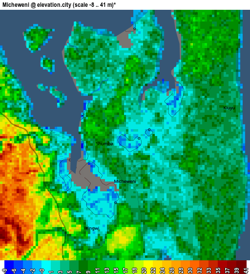
Below is the Elevation map of Micheweni, which displays elevation range with different colors. Scale of the first map is from -8 to 41 m (-26 to 135 ft) with average elevation of 8.6 meters (=28 ft) [note 1]
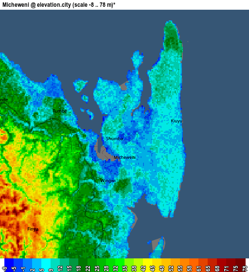
These maps also provides idea of topography and contour of this city, they are displayed at different zoom levels. More info about maps, scale and edge coordinates you can find below images.
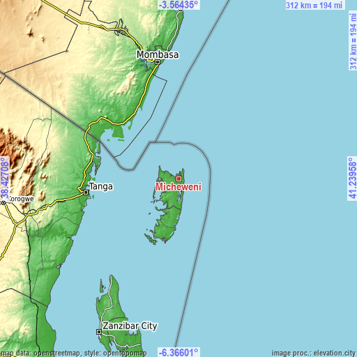
| \ | Map #1 | Map #2 | Topo.Map |
| Scale [m] | -8..41 m | -8..78 m | × |
| Scale [ft] | -26..135 ft | -26..256 ft | × |
| Average | 8.6 m = 28 ft | 19.5 m = 64 ft | × |
| Width | 9.74 km = 6.1 mi | 19.47 km = 12.1 mi | 311.5 km = 193.6 mi |
| Height | 9.74 km = 6.1 mi | 19.47 km = 12.1 mi | 311.5 km = 193.6 mi |
| ↑Max Latitude | -4.922888° | -4.879104° | -3.56435° |
| Latitude at center | -4.96667° | -4.96667° | -4.96667° |
| ↓Min Latitude | -5.010449° | -5.054225° | -6.36601° |
| ← Min Longitude | 39.789385° | 39.745439° | 38.42708° |
| Longitude center | 39.83333° | 39.83333° | 39.83333° |
| →Max Longitude | 39.877275° | 39.921221° | 41.23958° |
Nearby cities:
Cities around Micheweni sort by population:
• Tanga elevation 22 m
82.2 km,  262°
262°
• Wete 53 m
15.2 km,  229°
229°
• Chake Chake 19 m
31.9 km,  193°
193°
• Muheza 183 m
118.4 km, 259°
• Mlalo 133 m
99.8 km,  272°
272°
• Majengo 95 m
96.3 km, 257°
• Konde 22 m
9.4 km,  281°
281°
• Pangani 9 m
107.9 km,  241°
241°
• Nungwi 8 m
103.2 km,  215°
215°
• Mtambile 23 m
48.6 km,  197°
197°
• Kijini 38 m
113.7 km,  210°
210°
• Uwelini 49 m
51 km, 199°
Multilingual:
 En español:
Micheweni elevación 0 m.
 En France:
Micheweni élévation 0 m.


Sources and notes:
- [note 1] Map square and city borders are not equal. Map elevation data is calculated only from area inside that square.
- [src 1] Elevation data from geonames database provided with same terms of usage.
- [src 2] The elevation map of Micheweni is generated using elevation data from NASA's 3 arcsec (90m) resolution SRTM data.
- [src 3] Base (background) map © OpenStreetMap contributors tiles are generated by Geofabrik and OpenTopoMap.
Copyright & License:
This Micheweni Elevation Map is licensed under CC BY-SA. You may reuse any part from this page, if you give a proper credit by linking to this URL:
 More info on terms of use page.