Monduli elevation
Monduli (Arusha, Monduli District), Tanzania elevation is 1534 meters and Monduli elevation in feet is 5033 ft above sea level [src 1]. Monduli is a populated place (feature code) with elevation that is 591 meters (1939 ft) bigger than average city elevation in Tanzania.
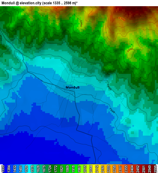
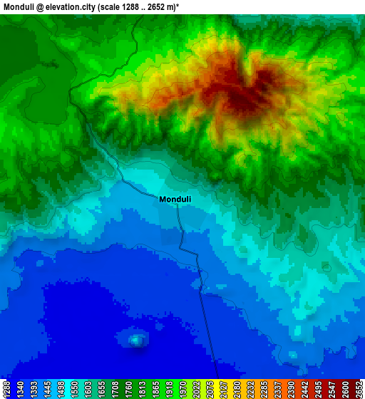
Below is the Elevation map of Monduli, which displays elevation range with different colors. Scale of the first map is from 1335 to 2598 m (4380 to 8524 ft) with average elevation of 1648.9 meters (=5410 ft) [note 1]
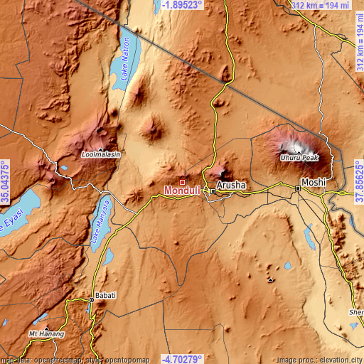
These maps also provides idea of topography and contour of this city, they are displayed at different zoom levels. More info about maps, scale and edge coordinates you can find below images.
| \ | Map #1 | Map #2 | Topo.Map |
| Scale [m] | 1335..2598 m | 1288..2652 m | × |
| Scale [ft] | 4380..8524 ft | 4226..8701 ft | × |
| Average | 1648.9 m = 5410 ft | 1664.5 m = 5461 ft | × |
| Width | 9.76 km = 6.1 mi | 19.51 km = 12.1 mi | 312.2 km = 194 mi |
| Height | 9.76 km = 6.1 mi | 19.51 km = 12.1 mi | 312.2 km = 194 mi |
| ↑Max Latitude | -3.256127° | -3.212251° | -1.89523° |
| Latitude at center | -3.3° | -3.3° | -3.3° |
| ↓Min Latitude | -3.343871° | -3.387741° | -4.70279° |
| ← Min Longitude | 36.406055° | 36.362109° | 35.04375° |
| Longitude center | 36.45° | 36.45° | 36.45° |
| →Max Longitude | 36.493945° | 36.537891° | 37.85625° |
Nearby cities:
Cities around Monduli sort by population:
• Arusha elevation 1415 m
26.9 km,  105°
105°
• Moshi 854 m
98.2 km,  93°
93°
• Merelani 916 m
65.5 km,  116°
116°
• Kingori 1165 m
59.2 km, 88°
• Kiratu 1541 m
87 km,  267°
267°
• Usa River 1197 m
45 km,  99°
99°
• Mto wa Mbu 985 m
66.8 km, 265°
• Mbuguni 921 m
62.9 km, 118°
• Nkoaranga 1644 m
39 km, 95°
• Namanga 1311 m
91.1 km,  23°
23°
• Poli 1644 m
39 km, 95°
• Longido 1348 m
68.8 km, 23°
Multilingual:
 En español:
Monduli elevación 1534 m.
 En France:
Monduli élévation 1534 m.
 Auf Deutsch:
Monduli höhe über dem Meeresspiegel ist 1534 m.

Sources and notes:
- [note 1] Map square and city borders are not equal. Map elevation data is calculated only from area inside that square.
- [src 1] Elevation data from geonames database provided with same terms of usage.
- [src 2] The elevation map of Monduli is generated using elevation data from NASA's 3 arcsec (90m) resolution SRTM data.
- [src 3] Base (background) map © OpenStreetMap contributors tiles are generated by Geofabrik and OpenTopoMap.
Copyright & License:
This Monduli Elevation Map is licensed under CC BY-SA. You may reuse any part from this page, if you give a proper credit by linking to this URL:
 More info on terms of use page.