Nangwa elevation
Nangwa (Manyara, Hanang District), Tanzania elevation is 1837 meters and Nangwa elevation in feet is 6027 ft above sea level [src 1]. Nangwa is a populated place (feature code) with elevation that is 894 meters (2933 ft) bigger than average city elevation in Tanzania.
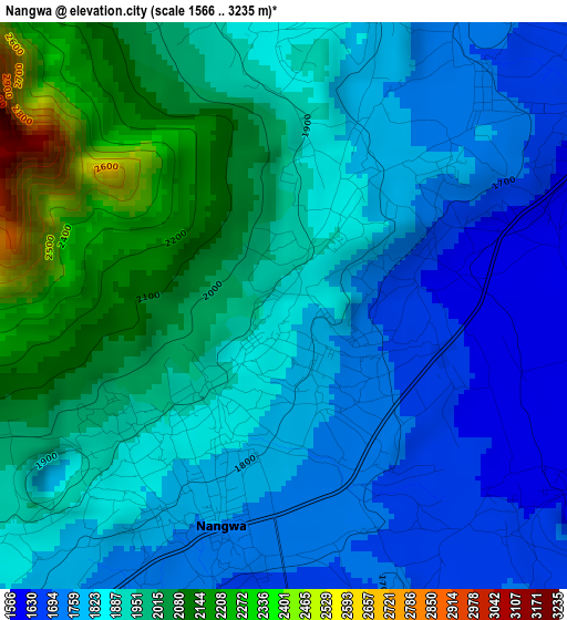
Below is the Elevation map of Nangwa, which displays elevation range with different colors. Scale of the first map is from 1566 to 3235 m (5138 to 10614 ft) with average elevation of 1893.7 meters (=6213 ft) [note 1]
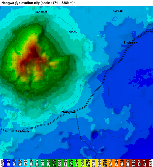
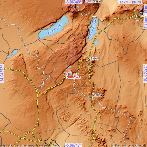
These maps also provides idea of topography and contour of this city, they are displayed at different zoom levels. More info about maps, scale and edge coordinates you can find below images.
| \ | Map #1 | Map #2 | Topo.Map |
| Scale [m] | 1566..3235 m | 1471..3389 m | × |
| Scale [ft] | 5138..10614 ft | 4826..11119 ft | × |
| Average | 1893.7 m = 6213 ft | 1813.2 m = 5949 ft | × |
| Width | 9.74 km = 6.1 mi | 19.49 km = 12.1 mi | 311.7 km = 193.7 mi |
| Height | 9.74 km = 6.1 mi | 19.49 km = 12.1 mi | 311.8 km = 193.7 mi |
| ↑Max Latitude | -4.422857° | -4.379041° | -3.06349° |
| Latitude at center | -4.46667° | -4.46667° | -4.46667° |
| ↓Min Latitude | -4.510481° | -4.554288° | -5.86717° |
| ← Min Longitude | 35.406055° | 35.362109° | 34.04375° |
| Longitude center | 35.45° | 35.45° | 35.45° |
| →Max Longitude | 35.493945° | 35.537891° | 36.85625° |
Nearby cities:
Cities around Nangwa sort by population:
• Babati elevation 1351 m
43.3 km,  50°
50°
• Mtinko 1583 m
67.1 km,  262°
262°
• Magugu 1013 m
61.1 km,  35°
35°
• Kondoa 1378 m
60.7 km,  142°
142°
• Basotu 1609 m
42.1 km,  285°
285°
• Dareda 1618 m
29.9 km,  21°
21°
• Bashanet 2044 m
26.2 km,  351°
351°
• Dongobesh 1985 m
45.1 km, 350°
• Galappo 1379 m
49.6 km,  63°
63°
• Ilongero 1609 m
68.4 km,  251°
251°
• Endasak 1600 m
9.2 km, 53°
• Katesh 1724 m
9.7 km,  228°
228°
Multilingual:
 En español:
Nangwa elevación 1837 m.
 En France:
Nangwa élévation 1837 m.


Sources and notes:
- [note 1] Map square and city borders are not equal. Map elevation data is calculated only from area inside that square.
- [src 1] Elevation data from geonames database provided with same terms of usage.
- [src 2] The elevation map of Nangwa is generated using elevation data from NASA's 3 arcsec (90m) resolution SRTM data.
- [src 3] Base (background) map © OpenStreetMap contributors tiles are generated by Geofabrik and OpenTopoMap.
Copyright & License:
This Nangwa Elevation Map is licensed under CC BY-SA. You may reuse any part from this page, if you give a proper credit by linking to this URL:
 More info on terms of use page.