Nansio elevation
Nansio (Mara), Tanzania elevation is 1134 meters and Nansio elevation in feet is 3720 ft above sea level [src 1]. Nansio is a populated place (feature code) with elevation that is 191 meters (627 ft) bigger than average city elevation in Tanzania.
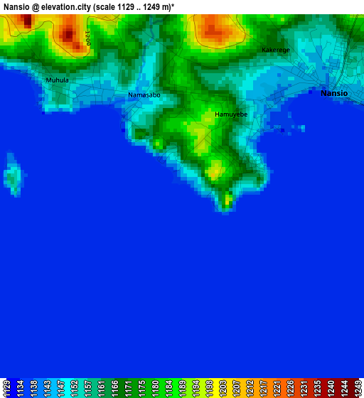
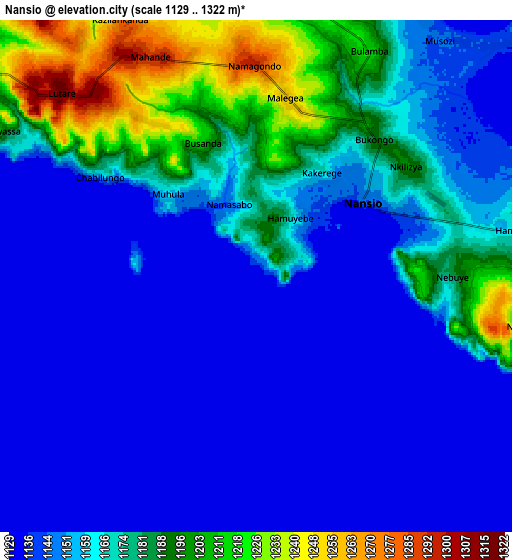
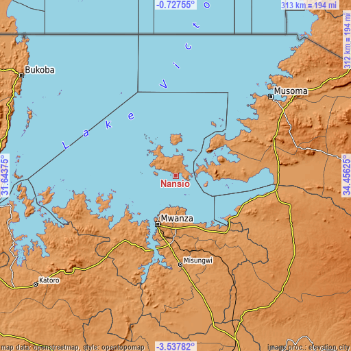
Below is the Elevation map of Nansio, which displays elevation range with different colors. Scale of the first map is from 1129 to 1249 m (3704 to 4098 ft) with average elevation of 1145 meters (=3757 ft) [note 1]
These maps also provides idea of topography and contour of this city, they are displayed at different zoom levels. More info about maps, scale and edge coordinates you can find below images.
| \ | Map #1 | Map #2 | Topo.Map |
| Scale [m] | 1129..1249 m | 1129..1322 m | × |
| Scale [ft] | 3704..4098 ft | 3704..4337 ft | × |
| Average | 1145 m = 3757 ft | 1161.4 m = 3810 ft | × |
| Width | 9.77 km = 6.1 mi | 19.53 km = 12.1 mi | 312.5 km = 194.2 mi |
| Height | 9.77 km = 6.1 mi | 19.53 km = 12.1 mi | 312.5 km = 194.2 mi |
| ↑Max Latitude | -2.089415° | -2.045498° | -0.72755° |
| Latitude at center | -2.13333° | -2.13333° | -2.13333° |
| ↓Min Latitude | -2.177244° | -2.221157° | -3.53782° |
| ← Min Longitude | 33.006055° | 32.962109° | 31.64375° |
| Longitude center | 33.05° | 33.05° | 33.05° |
| →Max Longitude | 33.093945° | 33.137891° | 34.45625° |
Nearby cities:
Cities around Nansio sort by population:
• Mwanza elevation 1144 m
45.8 km,  201°
201°
• Bunda 1174 m
91.2 km,  84°
84°
• Misungwi 1178 m
79.8 km,  177°
177°
• Muriti 1141 m
22.3 km,  318°
318°
• Kihangara 1186 m
60.1 km,  146°
146°
• Kibara 1149 m
44.5 km,  92°
92°
• Usagara 1294 m
61.4 km,  185°
185°
• Misasi 1151 m
96.4 km, 177°
• Nyanguge 1177 m
49.2 km,  160°
160°
• Mugango 1134 m
87.9 km,  55°
55°
• Nakatunguru 1151 m
2.6 km,  44°
44°
• Bukonyo 1146 m
24.2 km,  327°
327°
Multilingual:
 En español:
Nansio elevación 1134 m.
 En France:
Nansio élévation 1134 m.


Sources and notes:
- [note 1] Map square and city borders are not equal. Map elevation data is calculated only from area inside that square.
- [src 1] Elevation data from geonames database provided with same terms of usage.
- [src 2] The elevation map of Nansio is generated using elevation data from NASA's 3 arcsec (90m) resolution SRTM data.
- [src 3] Base (background) map © OpenStreetMap contributors tiles are generated by Geofabrik and OpenTopoMap.
Copyright & License:
This Nansio Elevation Map is licensed under CC BY-SA. You may reuse any part from this page, if you give a proper credit by linking to this URL:
 More info on terms of use page.