Old Shinyanga elevation
Old Shinyanga (Shinyanga, Shinyanga Urban), Tanzania elevation is 1177 meters and Old Shinyanga elevation in feet is 3862 ft above sea level [src 1]. Old Shinyanga is a populated place (feature code) with elevation that is 234 meters (768 ft) bigger than average city elevation in Tanzania.
Below is the Elevation map of Old Shinyanga, which displays elevation range with different colors. Scale of the first map is from 1135 to 1231 m (3724 to 4039 ft) with average elevation of 1173.3 meters (=3849 ft) [note 1]
These maps also provides idea of topography and contour of this city, they are displayed at different zoom levels. More info about maps, scale and edge coordinates you can find below images.
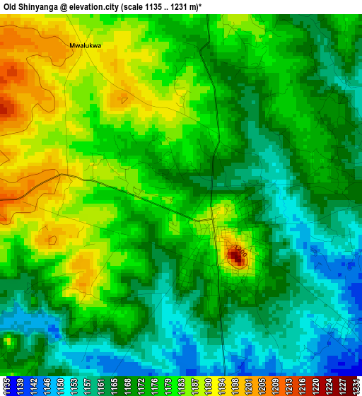
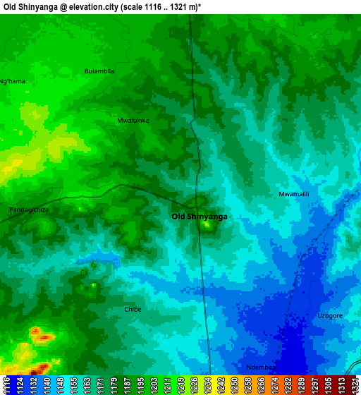
| \ | Map #1 | Map #2 | Topo.Map |
| Scale [m] | 1135..1231 m | 1116..1321 m | × |
| Scale [ft] | 3724..4039 ft | 3661..4334 ft | × |
| Average | 1173.3 m = 3849 ft | 1175 m = 3855 ft | × |
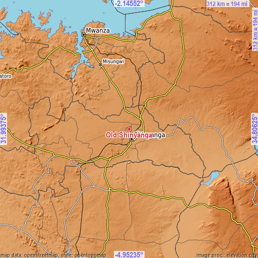
| Width | 9.75 km = 6.1 mi | 19.51 km = 12.1 mi | 312.1 km = 193.9 mi |
| Height | 9.75 km = 6.1 mi | 19.51 km = 12.1 mi | 312.1 km = 193.9 mi |
| ↑Max Latitude | -3.506138° | -3.462274° | -2.14552° |
| Latitude at center | -3.55° | -3.55° | -3.55° |
| ↓Min Latitude | -3.59386° | -3.637718° | -4.95235° |
| ← Min Longitude | 33.356055° | 33.312109° | 31.99375° |
| Longitude center | 33.4° | 33.4° | 33.4° |
| →Max Longitude | 33.443945° | 33.487891° | 34.80625° |
Nearby cities:
Cities around Old Shinyanga sort by population:
• Shinyanga elevation 1133 m
12.9 km,  169°
169°
• Somanda 1208 m
64.4 km,  71°
71°
• Nyalikungu 1354 m
58.9 km,  46°
46°
• Songwa 1149 m
13.5 km, 74°
• Mwadui 1215 m
22.2 km,  90°
90°
• Lalago 1176 m
62 km,  79°
79°
• Tinde 1154 m
43.2 km,  210°
210°
• Isaka 1201 m
64.8 km,  233°
233°
• Malampaka 1250 m
48.6 km,  17°
17°
• Kishapu 1169 m
52.3 km,  98°
98°
• Malya 1245 m
64.3 km,  11°
11°
• Igurubi 1087 m
60.1 km,  146°
146°
Multilingual:
 En español:
Old Shinyanga elevación 1177 m.
 En France:
Old Shinyanga élévation 1177 m.
 Auf Deutsch:
Old Shinyanga höhe über dem Meeresspiegel ist 1177 m.

Sources and notes:
- [note 1] Map square and city borders are not equal. Map elevation data is calculated only from area inside that square.
- [src 1] Elevation data from geonames database provided with same terms of usage.
- [src 2] The elevation map of Old Shinyanga is generated using elevation data from NASA's 3 arcsec (90m) resolution SRTM data.
- [src 3] Base (background) map © OpenStreetMap contributors tiles are generated by Geofabrik and OpenTopoMap.
Copyright & License:
This Old Shinyanga Elevation Map is licensed under CC BY-SA. You may reuse any part from this page, if you give a proper credit by linking to this URL:
 More info on terms of use page.