Sokoni elevation
Sokoni (Zanzibar Central/South, Kusini), Tanzania elevation is 24 meters and Sokoni elevation in feet is 79 ft above sea level [src 1]. Sokoni is a populated place (feature code) with elevation that is 919 meters (3015 ft) smaller than average city elevation in Tanzania.
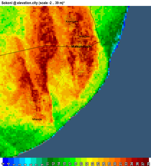
Below is the Elevation map of Sokoni, which displays elevation range with different colors. Scale of the first map is from -2 to 39 m (-7 to 128 ft) with average elevation of 24.7 meters (=81 ft) [note 1]
These maps also provides idea of topography and contour of this city, they are displayed at different zoom levels. More info about maps, scale and edge coordinates you can find below images.
| \ | Map #1 | Map #2 | Topo.Map |
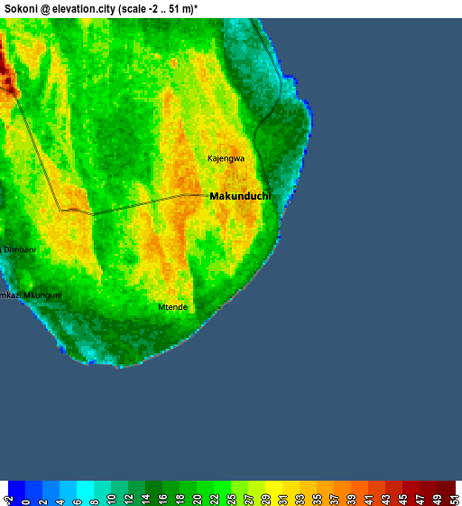
| Scale [m] | -2..39 m | -2..51 m | × |
| Scale [ft] | -7..128 ft | -7..167 ft | × |
| Average | 24.7 m = 81 ft | 23.1 m = 76 ft | × |
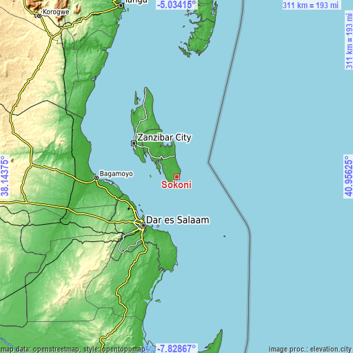
| Width | 9.71 km = 6 mi | 19.42 km = 12.1 mi | 310.7 km = 193.1 mi |
| Height | 9.71 km = 6 mi | 19.42 km = 12.1 mi | 310.8 km = 193.1 mi |
| ↑Max Latitude | -6.38966° | -6.345985° | -5.03415° |
| Latitude at center | -6.43333° | -6.43333° | -6.43333° |
| ↓Min Latitude | -6.476997° | -6.52066° | -7.82867° |
| ← Min Longitude | 39.506055° | 39.462109° | 38.14375° |
| Longitude center | 39.55° | 39.55° | 39.55° |
| →Max Longitude | 39.593945° | 39.637891° | 40.95625° |
Nearby cities:
Cities around Sokoni sort by population:
• Dar es Salaam elevation 24 m
53.3 km,  215°
215°
• Zanzibar 14 m
49.1 km,  307°
307°
• Vikindu 86 m
69.5 km,  203°
203°
• Magomeni 21 m
52.5 km, 219°
• Mahonda 5 m
9.4 km,  258°
258°
• Kijini 38 m
69.8 km,  338°
338°
• Gamba 41 m
65.4 km, 335°
• Mkokotoni 5 m
70.1 km,  332°
332°
• Kiwengwa 17 m
52.9 km, 338°
• Koani Ndogo 44 m
44.5 km,  318°
318°
• Koani 44 m
44.5 km, 318°
• Nganane 31 m
3.7 km,  0°
0°
Multilingual:
 En español:
Sokoni elevación 24 m.
 En France:
Sokoni élévation 24 m.


Sources and notes:
- [note 1] Map square and city borders are not equal. Map elevation data is calculated only from area inside that square.
- [src 1] Elevation data from geonames database provided with same terms of usage.
- [src 2] The elevation map of Sokoni is generated using elevation data from NASA's 3 arcsec (90m) resolution SRTM data.
- [src 3] Base (background) map © OpenStreetMap contributors tiles are generated by Geofabrik and OpenTopoMap.
Copyright & License:
This Sokoni Elevation Map is licensed under CC BY-SA. You may reuse any part from this page, if you give a proper credit by linking to this URL:
 More info on terms of use page.