Tunduma elevation
Tunduma (Songwe), Tanzania elevation is 1698 meters and Tunduma elevation in feet is 5571 ft above sea level [src 1]. Tunduma is a populated place (feature code) with elevation that is 755 meters (2477 ft) bigger than average city elevation in Tanzania.
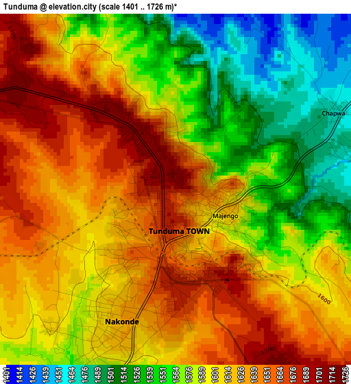
Below is the Elevation map of Tunduma, which displays elevation range with different colors. Scale of the first map is from 1401 to 1726 m (4596 to 5663 ft) with average elevation of 1596.7 meters (=5239 ft) [note 1]
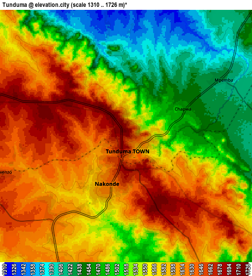
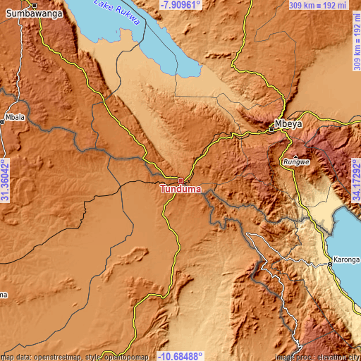
These maps also provides idea of topography and contour of this city, they are displayed at different zoom levels. More info about maps, scale and edge coordinates you can find below images.
| \ | Map #1 | Map #2 | Topo.Map |
| Scale [m] | 1401..1726 m | 1310..1726 m | × |
| Scale [ft] | 4596..5663 ft | 4298..5663 ft | × |
| Average | 1596.7 m = 5239 ft | 1550.3 m = 5086 ft | × |
| Width | 9.64 km = 6 mi | 19.29 km = 12 mi | 308.6 km = 191.8 mi |
| Height | 9.64 km = 6 mi | 19.29 km = 12 mi | 308.6 km = 191.8 mi |
| ↑Max Latitude | -9.25663° | -9.213254° | -7.90961° |
| Latitude at center | -9.3° | -9.3° | -9.3° |
| ↓Min Latitude | -9.343365° | -9.386725° | -10.68488° |
| ← Min Longitude | 32.722725° | 32.678779° | 31.36042° |
| Longitude center | 32.76667° | 32.76667° | 32.76667° |
| →Max Longitude | 32.810615° | 32.854561° | 34.17292° |
Nearby cities:
Cities around Tunduma sort by population:
• Mbeya elevation 1697 m
87.2 km,  59°
59°
• Katumba 1387 m
93.6 km,  85°
85°
• Vwawa 1331 m
28.2 km,  40°
40°
• Tukuyu 1431 m
97.1 km, 86°
• Kiwira 1360 m
86.2 km,  80°
80°
• Laela 1564 m
113.3 km,  316°
316°
• Mlowo 1591 m
41 km, 35°
• Itumba 1372 m
47 km,  103°
103°
• Masoko 887 m
108 km, 91°
• Ulenje 1929 m
108.6 km,  67°
67°
• Kandete 1578 m
114.6 km, 81°
• Ilembo 1954 m
67.9 km, 85°
Multilingual:
 En español:
Tunduma elevación 1698 m.
 En France:
Tunduma élévation 1698 m.
 Auf Deutsch:
Tunduma höhe über dem Meeresspiegel ist 1698 m.

Sources and notes:
- [note 1] Map square and city borders are not equal. Map elevation data is calculated only from area inside that square.
- [src 1] Elevation data from geonames database provided with same terms of usage.
- [src 2] The elevation map of Tunduma is generated using elevation data from NASA's 3 arcsec (90m) resolution SRTM data.
- [src 3] Base (background) map © OpenStreetMap contributors tiles are generated by Geofabrik and OpenTopoMap.
Copyright & License:
This Tunduma Elevation Map is licensed under CC BY-SA. You may reuse any part from this page, if you give a proper credit by linking to this URL:
 More info on terms of use page.