Pizitou elevation
Pizitou (Taiwan, Chiayi), Taiwan elevation is 38 meters and Pizitou elevation in feet is 125 ft above sea level [src 1]. Pizitou is a section of populated place (feature code) with elevation that is 41 meters (135 ft) smaller than average city elevation in Taiwan.
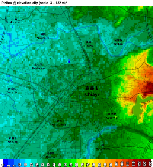
Below is the Elevation map of Pizitou, which displays elevation range with different colors. Scale of the first map is from -3 to 132 m (-10 to 433 ft) with average elevation of 38.4 meters (=126 ft) [note 1]
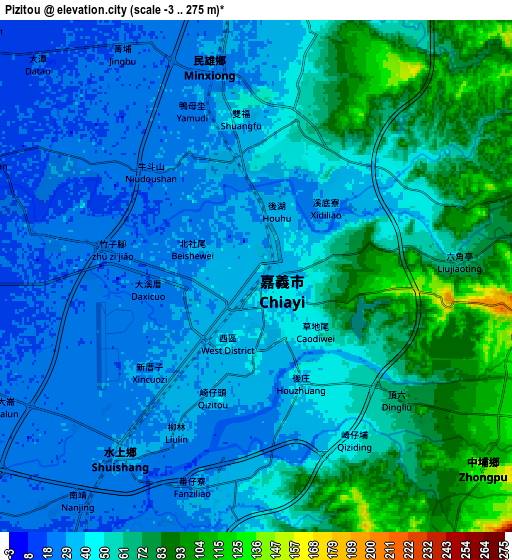
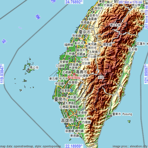
These maps also provides idea of topography and contour of this city, they are displayed at different zoom levels. More info about maps, scale and edge coordinates you can find below images.
| \ | Map #1 | Map #2 | Topo.Map |
| Scale [m] | -3..132 m | -3..275 m | × |
| Scale [ft] | -10..433 ft | -10..902 ft | × |
| Average | 38.4 m = 126 ft | 49.9 m = 164 ft | × |
| Width | 8.96 km = 5.6 mi | 17.93 km = 11.1 mi | 286.8 km = 178.2 mi |
| Height | 8.96 km = 5.6 mi | 17.93 km = 11.1 mi | 286.8 km = 178.2 mi |
| ↑Max Latitude | 23.525859° | 23.566145° | 24.76892° |
| Latitude at center | 23.48556° | 23.48556° | 23.48556° |
| ↓Min Latitude | 23.445249° | 23.404926° | 22.18959° |
| ← Min Longitude | 120.400775° | 120.356829° | 119.03847° |
| Longitude center | 120.44472° | 120.44472° | 120.44472° |
| →Max Longitude | 120.488665° | 120.532611° | 121.85097° |
Nearby cities:
Cities around Pizitou sort by population:
• Tainan elevation 26 m
59.9 km,  203°
203°
• Yuanlin 27 m
54.1 km,  14°
14°
• Nantou 196 m
52.8 km,  25°
25°
• Douliu 57 m
26.8 km,  21°
21°
• Puli 452 m
75.6 km,  44°
44°
• Zhongxing New Village 106 m
58.1 km, 24°
• Lugu 505 m
42.7 km,  47°
47°
• Yujing 67 m
40.1 km,  177°
177°
• Chang-hua 60 m
66.4 km, 10°
• Xinying 19 m
24.1 km,  214°
214°
• Taibao 11 m
11.8 km,  255°
255°
• Jiayi Shi 45 m
0.8 km,  149°
149°
Multilingual:
 En español:
Pizitou elevación 38 m.
 En France:
Pizitou élévation 38 m.


Sources and notes:
- [note 1] Map square and city borders are not equal. Map elevation data is calculated only from area inside that square.
- [src 1] Elevation data from geonames database provided with same terms of usage.
- [src 2] The elevation map of Pizitou is generated using elevation data from NASA's 3 arcsec (90m) resolution SRTM data.
- [src 3] Base (background) map © OpenStreetMap contributors tiles are generated by Geofabrik and OpenTopoMap.
Copyright & License:
This Pizitou Elevation Map is licensed under CC BY-SA. You may reuse any part from this page, if you give a proper credit by linking to this URL:
 More info on terms of use page.