Rio Claro elevation
Rio Claro (Mayaro), Trinidad and Tobago elevation is 45 meters and Rio Claro elevation in feet is 148 ft above sea level [src 1]. Rio Claro is a seat of a first-order administrative division (feature code) with elevation that is 8 meters (26 ft) bigger than average city elevation in Trinidad and Tobago.
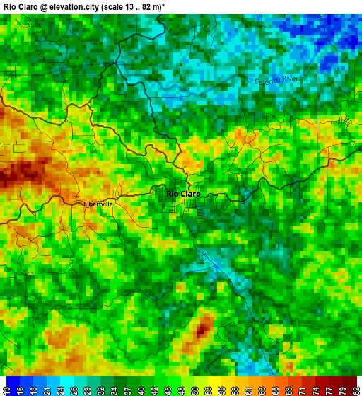
Below is the Elevation map of Rio Claro, which displays elevation range with different colors. Scale of the first map is from 13 to 82 m (43 to 269 ft) with average elevation of 42.6 meters (=140 ft) [note 1]
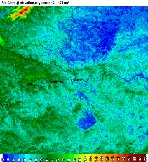
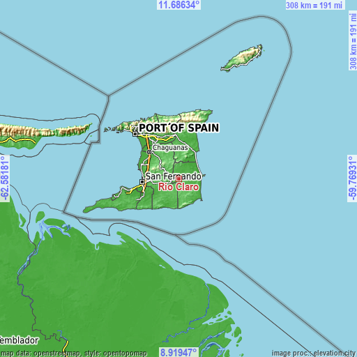
These maps also provides idea of topography and contour of this city, they are displayed at different zoom levels. More info about maps, scale and edge coordinates you can find below images.
| \ | Map #1 | Map #2 | Topo.Map |
| Scale [m] | 13..82 m | 12..171 m | × |
| Scale [ft] | 43..269 ft | 39..561 ft | × |
| Average | 42.6 m = 140 ft | 45.1 m = 148 ft | × |
| Width | 9.61 km = 6 mi | 19.23 km = 11.9 mi | 307.6 km = 191.1 mi |
| Height | 9.61 km = 6 mi | 19.23 km = 11.9 mi | 307.7 km = 191.2 mi |
| ↑Max Latitude | 10.349173° | 10.392401° | 11.68634° |
| Latitude at center | 10.30594° | 10.30594° | 10.30594° |
| ↓Min Latitude | 10.262701° | 10.219456° | 8.91947° |
| ← Min Longitude | -61.219505° | -61.263451° | -62.58181° |
| Longitude center | -61.17556° | -61.17556° | -61.17556° |
| →Max Longitude | -61.131615° | -61.087669° | -59.76931° |
Nearby cities:
Cities around Rio Claro sort by population:
• Chaguanas elevation 18 m
35.3 km,  311°
311°
• Mon Repos 37 m
29.7 km,  264°
264°
• San Fernando 28 m
32.2 km, 264°
• Arima 62 m
38.7 km,  342°
342°
• Marabella 7 m
29.7 km,  270°
270°
• Sangre Grande 17 m
31.6 km,  9°
9°
• Peñal 8 m
35.4 km,  244°
244°
• Arouca 31 m
39.9 km,  334°
334°
• Princes Town 69 m
21.7 km, 259°
• Couva 15 m
34.5 km,  292°
292°
• Tabaquite 100 m
16.1 km,  304°
304°
• Debe 19 m
32.2 km,  250°
250°
Multilingual:
 En español:
Rio Claro elevación 45 m.
 En France:
Río Claro élévation 45 m.
 Auf Deutsch:
Rio Claro höhe über dem Meeresspiegel ist 45 m.

Sources and notes:
- [note 1] Map square and city borders are not equal. Map elevation data is calculated only from area inside that square.
- [src 1] Elevation data from geonames database provided with same terms of usage.
- [src 2] The elevation map of Rio Claro is generated using elevation data from NASA's 3 arcsec (90m) resolution SRTM data.
- [src 3] Base (background) map © OpenStreetMap contributors tiles are generated by Geofabrik and OpenTopoMap.
Copyright & License:
This Rio Claro Elevation Map is licensed under CC BY-SA. You may reuse any part from this page, if you give a proper credit by linking to this URL:
 More info on terms of use page.