Ben Gardane elevation
Ben Gardane (Madanīn, Ben Guerdane), Tunisia elevation is 13 meters and Ben Gardane elevation in feet is 43 ft above sea level [src 1]. Ben Gardane is a populated place (feature code) with elevation that is 136 meters (446 ft) smaller than average city elevation in Tunisia.
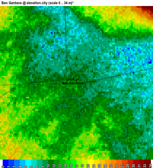
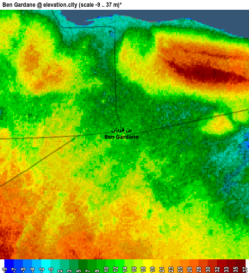
Below is the Elevation map of Ben Gardane, which displays elevation range with different colors. Scale of the first map is from 0 to 34 m (0 to 112 ft) with average elevation of 12.3 meters (=40 ft) [note 1]
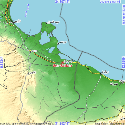
These maps also provides idea of topography and contour of this city, they are displayed at different zoom levels. More info about maps, scale and edge coordinates you can find below images.
| \ | Map #1 | Map #2 | Topo.Map |
| Scale [m] | 0..34 m | -9..37 m | × |
| Scale [ft] | 0..112 ft | -30..121 ft | × |
| Average | 12.3 m = 40 ft | 15.3 m = 50 ft | × |
| Width | 8.18 km = 5.1 mi | 16.37 km = 10.2 mi | 261.8 km = 162.7 mi |
| Height | 8.18 km = 5.1 mi | 16.37 km = 10.2 mi | 261.9 km = 162.7 mi |
| ↑Max Latitude | 33.17462° | 33.211395° | 34.30742° |
| Latitude at center | 33.13783° | 33.13783° | 33.13783° |
| ↓Min Latitude | 33.101024° | 33.064203° | 31.95244° |
| ← Min Longitude | 11.175705° | 11.131759° | 9.8134° |
| Longitude center | 11.21965° | 11.21965° | 11.21965° |
| →Max Longitude | 11.263595° | 11.307541° | 12.6259° |
Nearby cities:
Cities around Ben Gardane sort by population:
• Gabès elevation 9 m
132.8 km,  308°
308°
• Zarzis 11 m
41.9 km,  346°
346°
• Houmt El Souk 5 m
88.7 km,  337°
337°
• Tataouine 238 m
75.2 km,  252°
252°
• El Hamma 64 m
156.3 km,  302°
302°
• Medenine 90 m
70.7 km,  289°
289°
• Midoun 15 m
77.5 km, 344°
• Erriadh 11 m
83.2 km, 335°
• Remada 301 m
119.5 km,  220°
220°
• Beni Kheddache 518 m
95.8 km,  277°
277°
• Bou Attouche 55 m
157.7 km, 302°
• Matmata 378 m
124.4 km, 291°
Multilingual:
 En español:
Ben Gardane elevación 13 m.
 En France:
Ben Gardane élévation 13 m.
 Auf Deutsch:
Ben Gardane höhe über dem Meeresspiegel ist 13 m.

Sources and notes:
- [note 1] Map square and city borders are not equal. Map elevation data is calculated only from area inside that square.
- [src 1] Elevation data from geonames database provided with same terms of usage.
- [src 2] The elevation map of Ben Gardane is generated using elevation data from NASA's 3 arcsec (90m) resolution SRTM data.
- [src 3] Base (background) map © OpenStreetMap contributors tiles are generated by Geofabrik and OpenTopoMap.
Copyright & License:
This Ben Gardane Elevation Map is licensed under CC BY-SA. You may reuse any part from this page, if you give a proper credit by linking to this URL:
 More info on terms of use page.