Rhar el Melah elevation
Rhar el Melah (Banzart, Ghar El Melh), Tunisia elevation is 10 meters and Rhar el Melah elevation in feet is 33 ft above sea level [src 1]. Rhar el Melah is a populated place (feature code) with elevation that is 139 meters (456 ft) smaller than average city elevation in Tunisia.
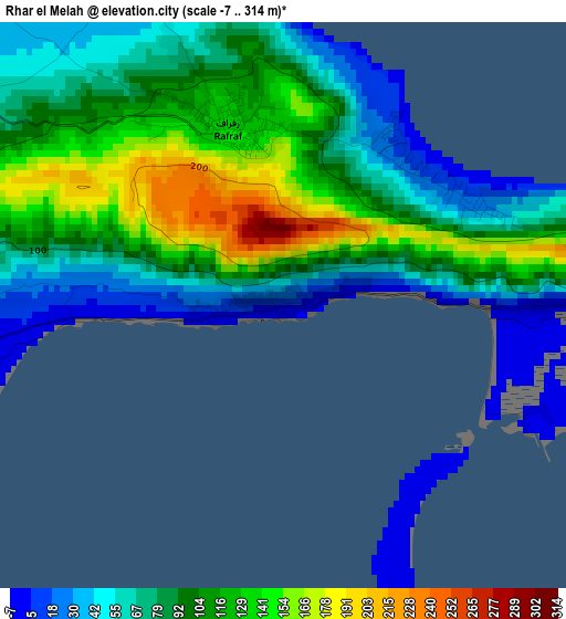
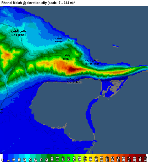
Below is the Elevation map of Rhar el Melah, which displays elevation range with different colors. Scale of the first map is from -7 to 314 m (-23 to 1030 ft) with average elevation of 92.3 meters (=303 ft) [note 1]
These maps also provides idea of topography and contour of this city, they are displayed at different zoom levels. More info about maps, scale and edge coordinates you can find below images.
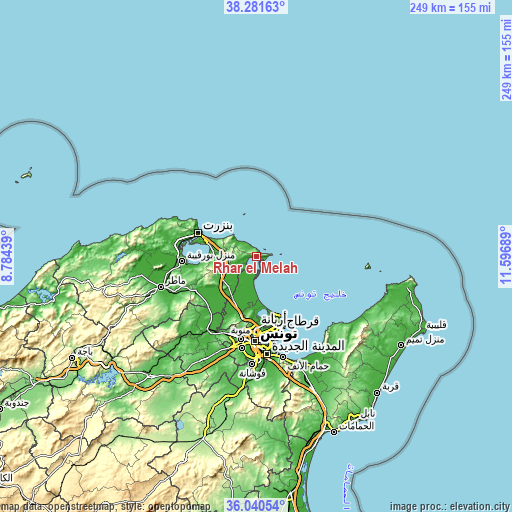
| \ | Map #1 | Map #2 | Topo.Map |
| Scale [m] | -7..314 m | -7..314 m | × |
| Scale [ft] | -23..1030 ft | -23..1030 ft | × |
| Average | 92.3 m = 303 ft | 50 m = 164 ft | × |
| Width | 7.79 km = 4.8 mi | 15.57 km = 9.7 mi | 249.2 km = 154.8 mi |
| Height | 7.79 km = 4.8 mi | 15.57 km = 9.7 mi | 249.2 km = 154.8 mi |
| ↑Max Latitude | 37.2044° | 37.239393° | 38.28163° |
| Latitude at center | 37.16939° | 37.16939° | 37.16939° |
| ↓Min Latitude | 37.134364° | 37.099322° | 36.04054° |
| ← Min Longitude | 10.146695° | 10.102749° | 8.78439° |
| Longitude center | 10.19064° | 10.19064° | 10.19064° |
| →Max Longitude | 10.234585° | 10.278531° | 11.59689° |
Nearby cities:
Cities around Rhar el Melah sort by population:
• Bizerte elevation 5 m
30.4 km,  292°
292°
• Ariana 11 m
34.4 km,  179°
179°
• Al Marsá 12 m
34.5 km,  159°
159°
• Menzel Bourguiba 9 m
35.9 km,  267°
267°
• Menzel Jemil 26 m
25.6 km, 286°
• El Alia 100 m
13.8 km, 269°
• Menzel Abderhaman 10 m
30 km,  284°
284°
• Galaat el Andeless 7 m
13.5 km,  208°
208°
• Rafrāf 136 m
2.4 km,  345°
345°
• Al Matlīn 180 m
15 km,  304°
304°
• Sidi Bou Saïd 69 m
36 km, 158°
• Zahānah 27 m
19.7 km,  223°
223°
Multilingual:
 En español:
Rhar el Melah elevación 10 m.
 En France:
Rhar el Melah élévation 10 m.
 Auf Deutsch:
Rhar el Melah höhe über dem Meeresspiegel ist 10 m.

Sources and notes:
- [note 1] Map square and city borders are not equal. Map elevation data is calculated only from area inside that square.
- [src 1] Elevation data from geonames database provided with same terms of usage.
- [src 2] The elevation map of Rhar el Melah is generated using elevation data from NASA's 3 arcsec (90m) resolution SRTM data.
- [src 3] Base (background) map © OpenStreetMap contributors tiles are generated by Geofabrik and OpenTopoMap.
Copyright & License:
This Rhar el Melah Elevation Map is licensed under CC BY-SA. You may reuse any part from this page, if you give a proper credit by linking to this URL:
 More info on terms of use page.