Nefta elevation
Nefta (Tawzar), Tunisia elevation is 65 meters and Nefta elevation in feet is 213 ft above sea level [src 1]. Nefta is a populated place (feature code) with elevation that is 84 meters (276 ft) smaller than average city elevation in Tunisia.
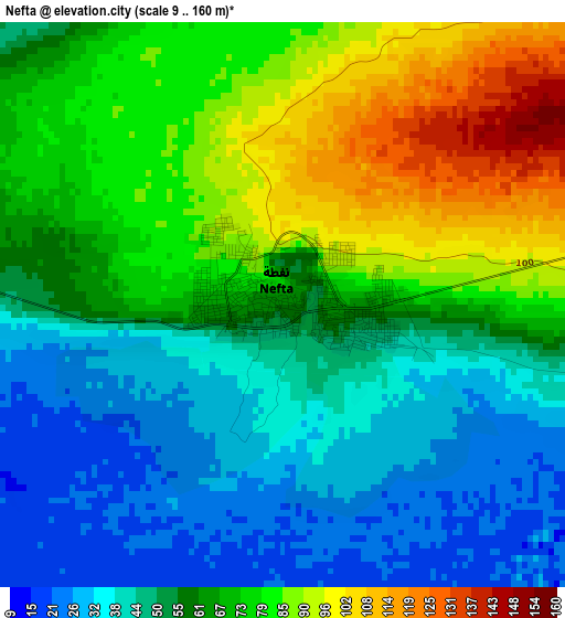
Below is the Elevation map of Nefta, which displays elevation range with different colors. Scale of the first map is from 9 to 160 m (30 to 525 ft) with average elevation of 61.9 meters (=203 ft) [note 1]
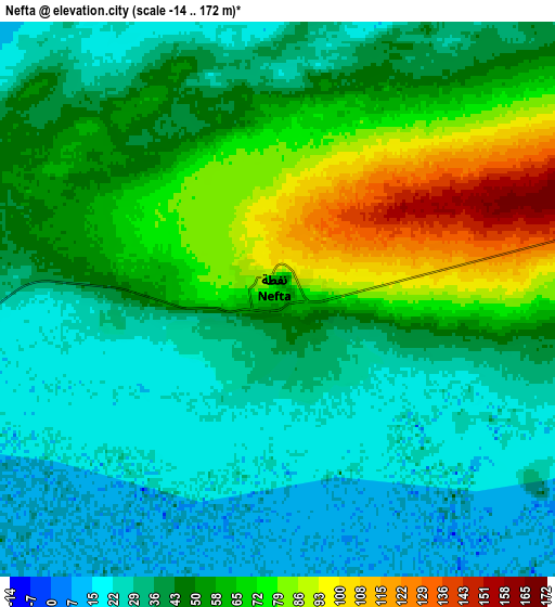
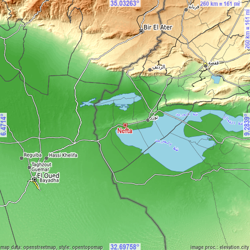
These maps also provides idea of topography and contour of this city, they are displayed at different zoom levels. More info about maps, scale and edge coordinates you can find below images.
| \ | Map #1 | Map #2 | Topo.Map |
| Scale [m] | 9..160 m | -14..172 m | × |
| Scale [ft] | 30..525 ft | -46..564 ft | × |
| Average | 61.9 m = 203 ft | 48.2 m = 158 ft | × |
| Width | 8.11 km = 5 mi | 16.23 km = 10.1 mi | 259.6 km = 161.3 mi |
| Height | 8.11 km = 5 mi | 16.23 km = 10.1 mi | 259.6 km = 161.3 mi |
| ↑Max Latitude | 33.909569° | 33.946032° | 35.03263° |
| Latitude at center | 33.87309° | 33.87309° | 33.87309° |
| ↓Min Latitude | 33.836596° | 33.800086° | 32.69758° |
| ← Min Longitude | 7.833705° | 7.789759° | 6.4714° |
| Longitude center | 7.87765° | 7.87765° | 7.87765° |
| →Max Longitude | 7.921595° | 7.965541° | 9.2839° |
Nearby cities:
Cities around Nefta sort by population:
• Gafsa elevation 295 m
103.6 km,  53°
53°
• Metlaoui 223 m
69.3 km,  44°
44°
• Tozeur 51 m
24.2 km,  77°
77°
• Ar Rudayyif 569 m
62.2 km,  24°
24°
• Douz 62 m
115 km,  113°
113°
• Kebili 43 m
102.6 km,  100°
100°
• Degache 58 m
32.6 km,  69°
69°
• As Sanad 600 m
143.4 km,  62°
62°
• El Golaa 56 m
113 km, 112°
• Jemna 42 m
110.2 km, 107°
• Tamaghzah 304 m
57.6 km,  6°
6°
• Chebika 116 m
49.9 km, 6°
Multilingual:
 En español:
Nefta elevación 65 m.
 En France:
Nefta élévation 65 m.


Sources and notes:
- [note 1] Map square and city borders are not equal. Map elevation data is calculated only from area inside that square.
- [src 1] Elevation data from geonames database provided with same terms of usage.
- [src 2] The elevation map of Nefta is generated using elevation data from NASA's 3 arcsec (90m) resolution SRTM data.
- [src 3] Base (background) map © OpenStreetMap contributors tiles are generated by Geofabrik and OpenTopoMap.
Copyright & License:
This Nefta Elevation Map is licensed under CC BY-SA. You may reuse any part from this page, if you give a proper credit by linking to this URL:
 More info on terms of use page.