Takelsa elevation
Takelsa (Nābul), Tunisia elevation is 121 meters and Takelsa elevation in feet is 397 ft above sea level [src 1]. Takelsa is a populated place (feature code) with elevation that is 28 meters (92 ft) smaller than average city elevation in Tunisia.
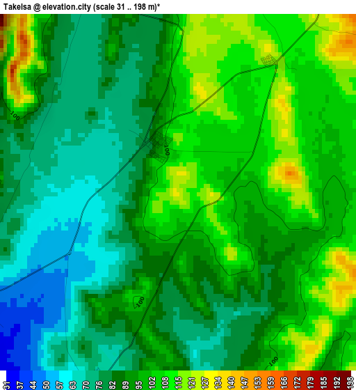
Below is the Elevation map of Takelsa, which displays elevation range with different colors. Scale of the first map is from 31 to 198 m (102 to 650 ft) with average elevation of 91.3 meters (=300 ft) [note 1]
These maps also provides idea of topography and contour of this city, they are displayed at different zoom levels. More info about maps, scale and edge coordinates you can find below images.
| \ | Map #1 | Map #2 | Topo.Map |
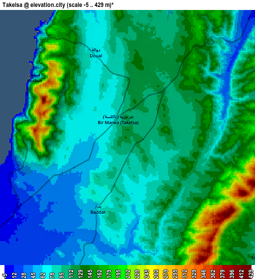
| Scale [m] | 31..198 m | -5..429 m | × |
| Scale [ft] | 102..650 ft | -16..1407 ft | × |
| Average | 91.3 m = 300 ft | 108 m = 354 ft | × |
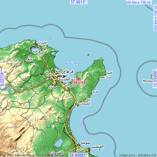
| Width | 7.83 km = 4.9 mi | 15.65 km = 9.7 mi | 250.5 km = 155.7 mi |
| Height | 7.83 km = 4.9 mi | 15.65 km = 9.7 mi | 250.5 km = 155.7 mi |
| ↑Max Latitude | 36.818518° | 36.85369° | 37.9013° |
| Latitude at center | 36.78333° | 36.78333° | 36.78333° |
| ↓Min Latitude | 36.748126° | 36.712906° | 35.64881° |
| ← Min Longitude | 10.589385° | 10.545439° | 9.22708° |
| Longitude center | 10.63333° | 10.63333° | 10.63333° |
| →Max Longitude | 10.677275° | 10.721221° | 12.03958° |
Nearby cities:
Cities around Takelsa sort by population:
• La Goulette elevation 3 m
29.5 km,  277°
277°
• Al Marsá 12 m
29.4 km,  291°
291°
• Hammam-Lif 3 m
26.7 km,  256°
256°
• Mennzel Bou Zelfa 48 m
12 km,  201°
201°
• Carthage 43 m
28.2 km, 287°
• Beni Khalled 50 m
15.3 km,  194°
194°
• Bou Arkoub 69 m
28.2 km, 195°
• Zaouiat Djedidi 45 m
16.4 km, 198°
• Sidi Bou Saïd 69 m
27.6 km, 290°
• Menzel Heurr 15 m
29.5 km,  101°
101°
• El Mida 51 m
20.8 km,  107°
107°
• Korbous 16 m
6.8 km,  302°
302°
Multilingual:
 En español:
Takelsa elevación 121 m.
 En France:
Takelsa élévation 121 m.


Sources and notes:
- [note 1] Map square and city borders are not equal. Map elevation data is calculated only from area inside that square.
- [src 1] Elevation data from geonames database provided with same terms of usage.
- [src 2] The elevation map of Takelsa is generated using elevation data from NASA's 3 arcsec (90m) resolution SRTM data.
- [src 3] Base (background) map © OpenStreetMap contributors tiles are generated by Geofabrik and OpenTopoMap.
Copyright & License:
This Takelsa Elevation Map is licensed under CC BY-SA. You may reuse any part from this page, if you give a proper credit by linking to this URL:
 More info on terms of use page.