Zaghouan elevation
Zaghouan (Zaghwān), Tunisia elevation is 176 meters and Zaghouan elevation in feet is 577 ft above sea level [src 1]. Zaghouan is a seat of a first-order administrative division (feature code) with elevation that is 27 meters (89 ft) bigger than average city elevation in Tunisia.
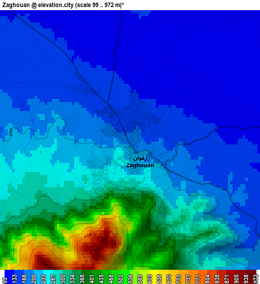
Below is the Elevation map of Zaghouan, which displays elevation range with different colors. Scale of the first map is from 99 to 972 m (325 to 3189 ft) with average elevation of 233.9 meters (=767 ft) [note 1]
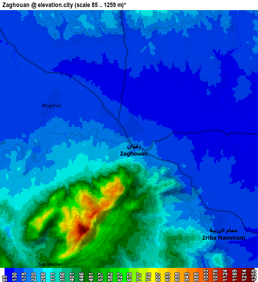
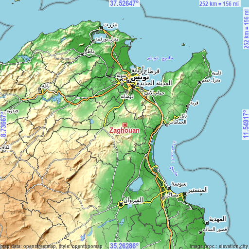
These maps also provides idea of topography and contour of this city, they are displayed at different zoom levels. More info about maps, scale and edge coordinates you can find below images.
| \ | Map #1 | Map #2 | Topo.Map |
| Scale [m] | 99..972 m | 85..1259 m | × |
| Scale [ft] | 325..3189 ft | 279..4131 ft | × |
| Average | 233.9 m = 767 ft | 243.4 m = 799 ft | × |
| Width | 7.87 km = 4.9 mi | 15.73 km = 9.8 mi | 251.7 km = 156.4 mi |
| Height | 7.87 km = 4.9 mi | 15.73 km = 9.8 mi | 251.7 km = 156.4 mi |
| ↑Max Latitude | 36.438272° | 36.473618° | 37.52647° |
| Latitude at center | 36.40291° | 36.40291° | 36.40291° |
| ↓Min Latitude | 36.367532° | 36.332138° | 35.26286° |
| ← Min Longitude | 10.098975° | 10.055029° | 8.73667° |
| Longitude center | 10.14292° | 10.14292° | 10.14292° |
| →Max Longitude | 10.186865° | 10.230811° | 11.54917° |
Nearby cities:
Cities around Zaghouan sort by population:
• Tunis elevation 23 m
46.3 km,  2°
2°
• Ben Arous 44 m
39.7 km,  10°
10°
• La Mohammedia 63 m
30.2 km, 2°
• Hammamet 13 m
42.4 km,  90°
90°
• Hammam-Lif 3 m
40.3 km,  26°
26°
• Radès 5 m
42.4 km,  16°
16°
• La Sebala du Mornag 32 m
33.5 km, 23°
• Manouba 35 m
45.5 km,  354°
354°
• El Fahs 195 m
21.4 km,  261°
261°
• Bou Arkoub 69 m
39.5 km,  67°
67°
• Zaouiat Djedidi 45 m
46.9 km,  55°
55°
• Goubellat 138 m
45.6 km,  289°
289°
Multilingual:
 En español:
Zaghouan elevación 176 m.
 En France:
Zaghouan élévation 176 m.
 Auf Deutsch:
Zaghouan höhe über dem Meeresspiegel ist 176 m.

Sources and notes:
- [note 1] Map square and city borders are not equal. Map elevation data is calculated only from area inside that square.
- [src 1] Elevation data from geonames database provided with same terms of usage.
- [src 2] The elevation map of Zaghouan is generated using elevation data from NASA's 3 arcsec (90m) resolution SRTM data.
- [src 3] Base (background) map © OpenStreetMap contributors tiles are generated by Geofabrik and OpenTopoMap.
Copyright & License:
This Zaghouan Elevation Map is licensed under CC BY-SA. You may reuse any part from this page, if you give a proper credit by linking to this URL:
 More info on terms of use page.