Serhetabat elevation
Serhetabat (Mary), Turkmenistan elevation is 643 meters and Serhetabat elevation in feet is 2110 ft above sea level [src 1]. Serhetabat is a populated place (feature code) with elevation that is 447 meters (1467 ft) bigger than average city elevation in Turkmenistan.
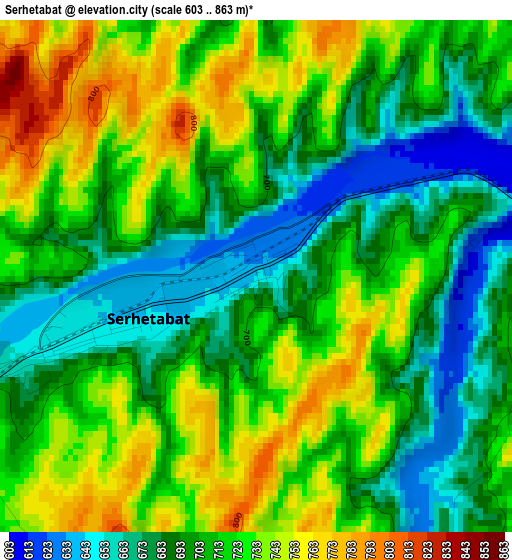
Below is the Elevation map of Serhetabat, which displays elevation range with different colors. Scale of the first map is from 603 to 863 m (1978 to 2831 ft) with average elevation of 709.4 meters (=2327 ft) [note 1]
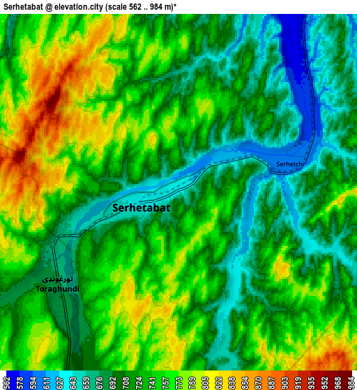
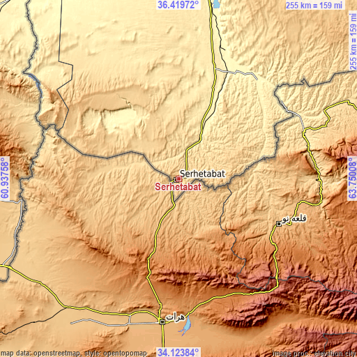
These maps also provides idea of topography and contour of this city, they are displayed at different zoom levels. More info about maps, scale and edge coordinates you can find below images.
| \ | Map #1 | Map #2 | Topo.Map |
| Scale [m] | 603..863 m | 562..984 m | × |
| Scale [ft] | 1978..2831 ft | 1844..3228 ft | × |
| Average | 709.4 m = 2327 ft | 727.9 m = 2388 ft | × |
| Width | 7.98 km = 5 mi | 15.96 km = 9.9 mi | 255.3 km = 158.6 mi |
| Height | 7.98 km = 5 mi | 15.96 km = 9.9 mi | 255.3 km = 158.6 mi |
| ↑Max Latitude | 35.315786° | 35.351637° | 36.41972° |
| Latitude at center | 35.27992° | 35.27992° | 35.27992° |
| ↓Min Latitude | 35.244038° | 35.20814° | 34.12384° |
| ← Min Longitude | 62.299885° | 62.255939° | 60.93758° |
| Longitude center | 62.34383° | 62.34383° | 62.34383° |
| →Max Longitude | 62.387775° | 62.431721° | 63.75008° |
Nearby cities:
Cities around Serhetabat sort by population:
• Türkmenabat elevation 191 m
435.7 km,  14°
14°
• Mary 223 m
261.3 km,  349°
349°
• Bayramaly 239 m
260.5 km,  356°
356°
• Tejen 190 m
286 km,  324°
324°
• Yolöten 263 m
224.5 km,  0°
0°
• Atamyrat 244 m
382.5 km,  42°
42°
• Kaka 290 m
335.7 km,  313°
313°
• Saýat 203 m
412.8 km,  19°
19°
• Murgab 228 m
248.7 km, 352°
Multilingual:
 En español:
Serhetabat elevación 643 m.
 En France:
Serhetabat élévation 643 m.
 Auf Deutsch:
Serhetabat höhe über dem Meeresspiegel ist 643 m.

Sources and notes:
- [note 1] Map square and city borders are not equal. Map elevation data is calculated only from area inside that square.
- [src 1] Elevation data from geonames database provided with same terms of usage.
- [src 2] The elevation map of Serhetabat is generated using elevation data from NASA's 3 arcsec (90m) resolution SRTM data.
- [src 3] Base (background) map © OpenStreetMap contributors tiles are generated by Geofabrik and OpenTopoMap.
Copyright & License:
This Serhetabat Elevation Map is licensed under CC BY-SA. You may reuse any part from this page, if you give a proper credit by linking to this URL:
 More info on terms of use page.