Venilale elevation
Venilale (Baucau), Timor Leste elevation is 834 meters and Venilale elevation in feet is 2736 ft above sea level [src 1]. Venilale is a populated place (feature code) with elevation that is 528 meters (1732 ft) bigger than average city elevation in Timor Leste.
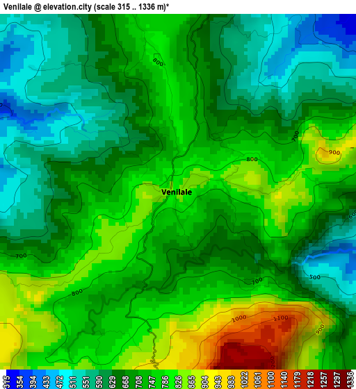
Below is the Elevation map of Venilale, which displays elevation range with different colors. Scale of the first map is from 315 to 1336 m (1033 to 4383 ft) with average elevation of 710 meters (=2329 ft) [note 1]
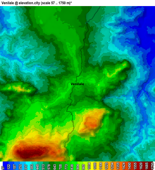
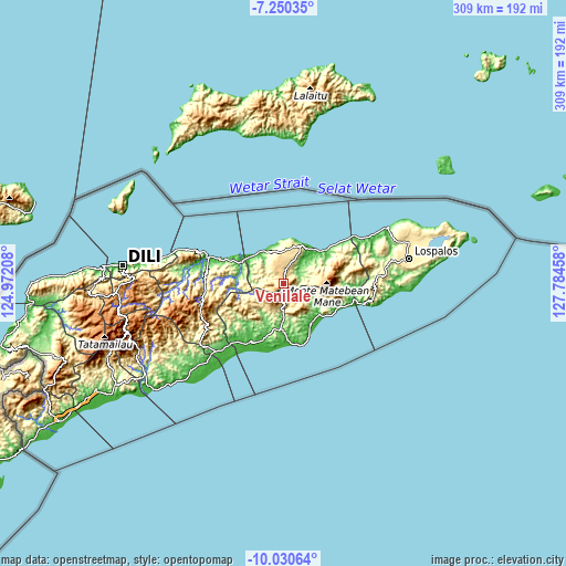
These maps also provides idea of topography and contour of this city, they are displayed at different zoom levels. More info about maps, scale and edge coordinates you can find below images.
| \ | Map #1 | Map #2 | Topo.Map |
| Scale [m] | 315..1336 m | 57..1750 m | × |
| Scale [ft] | 1033..4383 ft | 187..5741 ft | × |
| Average | 710 m = 2329 ft | 616.3 m = 2022 ft | × |
| Width | 9.66 km = 6 mi | 19.32 km = 12 mi | 309.1 km = 192.1 mi |
| Height | 9.66 km = 6 mi | 19.32 km = 12 mi | 309.2 km = 192.1 mi |
| ↑Max Latitude | -8.599611° | -8.556158° | -7.25035° |
| Latitude at center | -8.64306° | -8.64306° | -8.64306° |
| ↓Min Latitude | -8.686504° | -8.729942° | -10.03064° |
| ← Min Longitude | 126.334385° | 126.290439° | 124.97208° |
| Longitude center | 126.37833° | 126.37833° | 126.37833° |
| →Max Longitude | 126.422275° | 126.466221° | 127.78458° |
Nearby cities:
Cities around Venilale sort by population:
• Dili elevation 3 m
89 km,  276°
276°
• Likisá 23 m
114.1 km,  273°
273°
• Aileu 926 m
89.7 km,  263°
263°
• Lospalos 341 m
69.5 km,  78°
78°
• Maubara 21 m
128.9 km, 271°
• Baukau 367 m
20.5 km,  24°
24°
• Ainaro 820 m
103.2 km,  247°
247°
• Gleno 709 m
104 km, 265°
• Same 426 m
89.7 km,  243°
243°
• Viqueque 55 m
23.9 km,  183°
183°
• Metinaro 15 m
71.1 km, 280°
• Manatutu 8 m
42.7 km,  290°
290°
Multilingual:
 En español:
Venilale elevación 834 m.
 En France:
Venilale élévation 834 m.
 Auf Deutsch:
Venilale höhe über dem Meeresspiegel ist 834 m.

Sources and notes:
- [note 1] Map square and city borders are not equal. Map elevation data is calculated only from area inside that square.
- [src 1] Elevation data from geonames database provided with same terms of usage.
- [src 2] The elevation map of Venilale is generated using elevation data from NASA's 3 arcsec (90m) resolution SRTM data.
- [src 3] Base (background) map © OpenStreetMap contributors tiles are generated by Geofabrik and OpenTopoMap.
Copyright & License:
This Venilale Elevation Map is licensed under CC BY-SA. You may reuse any part from this page, if you give a proper credit by linking to this URL:
 More info on terms of use page.