Ayní elevation
Ayní (Sughd), Tajikistan elevation is 1433 meters and Ayní elevation in feet is 4701 ft above sea level [src 1]. Ayní is a seat of a second-order administrative division (feature code) with elevation that is 479 meters (1572 ft) bigger than average city elevation in Tajikistan.
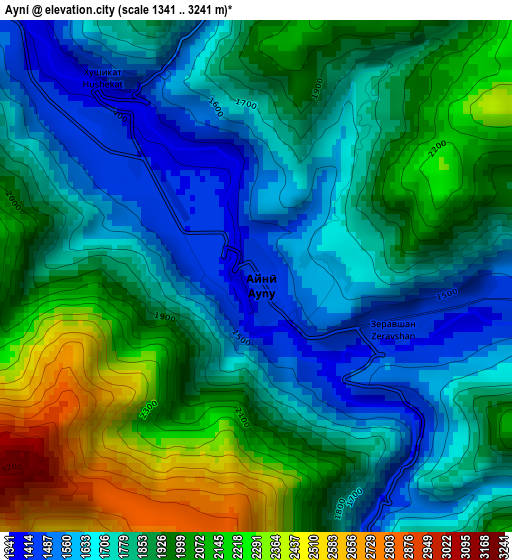
Below is the Elevation map of Ayní, which displays elevation range with different colors. Scale of the first map is from 1341 to 3241 m (4400 to 10633 ft) with average elevation of 1870.1 meters (=6135 ft) [note 1]
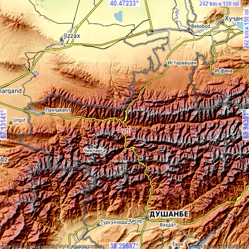
These maps also provides idea of topography and contour of this city, they are displayed at different zoom levels. More info about maps, scale and edge coordinates you can find below images.
| \ | Map #1 | Topo.Map |
| Scale [m] | 1341..3241 m | × |
| Scale [ft] | 4400..10633 ft | × |
| Average | 1870.1 m = 6135 ft | × |
| Width | 7.55 km = 4.7 mi | 241.7 km = 150.2 mi |
| Height | 7.55 km = 4.7 mi | 241.7 km = 150.2 mi |
| ↑Max Latitude | 39.428013° | 40.47233° |
| Latitude at center | 39.39406° | 39.39406° |
| ↓Min Latitude | 39.360091° | 38.29887° |
| ← Min Longitude | 68.493715° | 67.13141° |
| Longitude center | 68.53766° | 68.53766° |
| →Max Longitude | 68.581605° | 69.94391° |
Nearby cities:
Cities around Ayní sort by population:
• Istaravshan elevation 979 m
70.2 km,  34°
34°
• Panjakent 998 m
80.5 km,  278°
278°
• Hisor 800 m
96.6 km,  179°
179°
• Khodzha-Maston 1565 m
72.6 km,  173°
173°
• Pakhtakoron 387 m
86.7 km,  11°
11°
• Shahrinav 850 m
93.2 km,  190°
190°
• Tagob 1467 m
69.2 km,  153°
153°
• Varzob 1107 m
73.1 km,  160°
160°
• Zafarobod 405 m
90.9 km,  16°
16°
• Ghonchí 907 m
81 km,  38°
38°
• Mehron 2043 m
64.4 km,  87°
87°
• Shahriston 1438 m
48.3 km, 28°
Multilingual:
 En español:
Ayní elevación 1433 m.
 En France:
Ayní élévation 1433 m.


Sources and notes:
- [note 1] Map square and city borders are not equal. Map elevation data is calculated only from area inside that square.
- [src 1] Elevation data from geonames database provided with same terms of usage.
- [src 2] The elevation map of Ayní is generated using elevation data from NASA's 3 arcsec (90m) resolution SRTM data.
- [src 3] Base (background) map © OpenStreetMap contributors tiles are generated by Geofabrik and OpenTopoMap.
Copyright & License:
This Ayní Elevation Map is licensed under CC BY-SA. You may reuse any part from this page, if you give a proper credit by linking to this URL:
 More info on terms of use page.