Phak Hai elevation
Phak Hai (Phra Nakhon Si Ayutthaya), Thailand elevation is 11 meters and Phak Hai elevation in feet is 36 ft above sea level [src 1]. Phak Hai is a seat of a second-order administrative division (feature code) with elevation that is 114 meters (374 ft) smaller than average city elevation in Thailand.
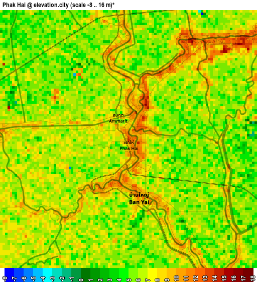
Below is the Elevation map of Phak Hai, which displays elevation range with different colors. Scale of the first map is from -8 to 16 m (-26 to 52 ft) with average elevation of 6.2 meters (=20 ft) [note 1]
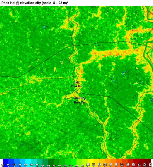
These maps also provides idea of topography and contour of this city, they are displayed at different zoom levels. More info about maps, scale and edge coordinates you can find below images.
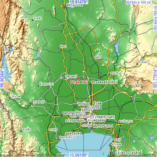
| \ | Map #1 | Map #2 | Topo.Map |
| Scale [m] | -8..16 m | -8..23 m | × |
| Scale [ft] | -26..52 ft | -26..75 ft | × |
| Average | 6.2 m = 20 ft | 6.1 m = 20 ft | × |
| Width | 9.46 km = 5.9 mi | 18.93 km = 11.8 mi | 302.8 km = 188.2 mi |
| Height | 9.46 km = 5.9 mi | 18.93 km = 11.8 mi | 302.8 km = 188.2 mi |
| ↑Max Latitude | 14.49991° | 14.542451° | 15.81479° |
| Latitude at center | 14.45736° | 14.45736° | 14.45736° |
| ↓Min Latitude | 14.414802° | 14.372236° | 13.09159° |
| ← Min Longitude | 100.325945° | 100.281999° | 98.96364° |
| Longitude center | 100.36989° | 100.36989° | 100.36989° |
| →Max Longitude | 100.413835° | 100.457781° | 101.77614° |
Nearby cities:
Cities around Phak Hai sort by population:
• Wiset Chaichan elevation 12 m
15.6 km,  347°
347°
• Bang Ban 10 m
15.5 km,  126°
126°
• Ban Thai Tan 11 m
22.2 km,  34°
34°
• Ang Thong 12 m
17.1 km, 31°
• Pho Thong 12 m
23.7 km,  10°
10°
• Bang Pla Ma 10 m
23.7 km,  253°
253°
• Sam Ko 13 m
23.3 km,  315°
315°
• Maha Rat 12 m
18.9 km,  63°
63°
• Bang Pahan 8 m
18.8 km,  88°
88°
• Bang Sai 8 m
15.4 km,  207°
207°
• Sena 13 m
15 km,  165°
165°
• Pa Mok 7 m
9.2 km,  66°
66°
Multilingual:
 En español:
Phak Hai elevación 11 m.
 En France:
Phak Hai élévation 11 m.


Sources and notes:
- [note 1] Map square and city borders are not equal. Map elevation data is calculated only from area inside that square.
- [src 1] Elevation data from geonames database provided with same terms of usage.
- [src 2] The elevation map of Phak Hai is generated using elevation data from NASA's 3 arcsec (90m) resolution SRTM data.
- [src 3] Base (background) map © OpenStreetMap contributors tiles are generated by Geofabrik and OpenTopoMap.
Copyright & License:
This Phak Hai Elevation Map is licensed under CC BY-SA. You may reuse any part from this page, if you give a proper credit by linking to this URL:
 More info on terms of use page.