Phibun Mangsahan elevation
Phibun Mangsahan (Changwat Ubon Ratchathani), Thailand elevation is 127 meters and Phibun Mangsahan elevation in feet is 417 ft above sea level [src 1]. Phibun Mangsahan is a seat of a second-order administrative division (feature code) with elevation that is 2 meters (7 ft) bigger than average city elevation in Thailand.
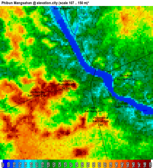
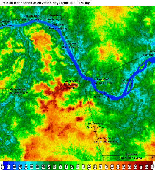
Below is the Elevation map of Phibun Mangsahan, which displays elevation range with different colors. Scale of the first map is from 107 to 150 m (351 to 492 ft) with average elevation of 127.4 meters (=418 ft) [note 1]
These maps also provides idea of topography and contour of this city, they are displayed at different zoom levels. More info about maps, scale and edge coordinates you can find below images.
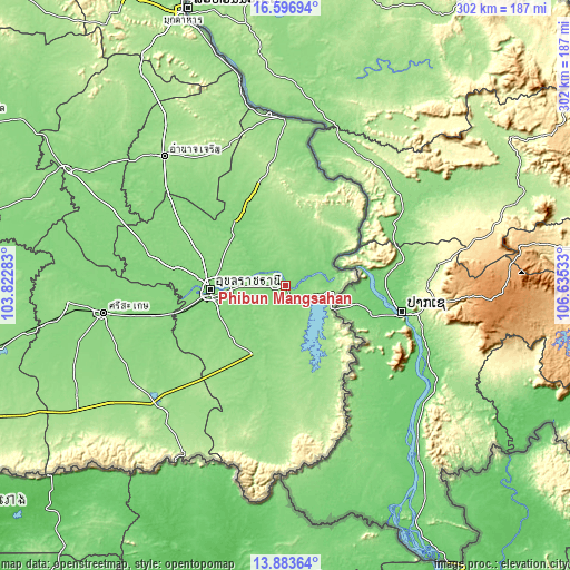
| \ | Map #1 | Map #2 | Topo.Map |
| Scale [m] | 107..150 m | 107..150 m | × |
| Scale [ft] | 351..492 ft | 351..492 ft | × |
| Average | 127.4 m = 418 ft | 125.9 m = 413 ft | × |
| Width | 9.43 km = 5.9 mi | 18.86 km = 11.7 mi | 301.7 km = 187.5 mi |
| Height | 9.43 km = 5.9 mi | 18.86 km = 11.7 mi | 301.7 km = 187.5 mi |
| ↑Max Latitude | 15.287065° | 15.329451° | 16.59694° |
| Latitude at center | 15.24467° | 15.24467° | 15.24467° |
| ↓Min Latitude | 15.202267° | 15.159855° | 13.88364° |
| ← Min Longitude | 105.185135° | 105.141189° | 103.82283° |
| Longitude center | 105.22908° | 105.22908° | 105.22908° |
| →Max Longitude | 105.273025° | 105.316971° | 106.63533° |
Nearby cities:
Cities around Phibun Mangsahan sort by population:
• Ubon Ratchathani elevation 125 m
40.8 km,  269°
269°
• Warin Chamrap 136 m
39.7 km,  261°
261°
• Det Udom 137 m
41 km,  203°
203°
• Sawang Wirawong 138 m
14.7 km, 268°
• Trakan Phut Phon 136 m
46.5 km,  331°
331°
• Lao Suea Kok 141 m
38 km,  300°
300°
• Khong Chiam 113 m
29.7 km,  73°
73°
• Si Mueang Mai 146 m
28.1 km,  10°
10°
• Na Yia 130 m
27.1 km,  222°
222°
• Don Mot Daeng 126 m
26.2 km, 304°
• Sirindhorn 157 m
18.2 km,  105°
105°
• Tan Sum 128 m
11.2 km,  314°
314°
Multilingual:
 En español:
Phibun Mangsahan elevación 127 m.
 En France:
Phibun Mangsahan élévation 127 m.
 Auf Deutsch:
Phibun Mangsahan höhe über dem Meeresspiegel ist 127 m.

Sources and notes:
- [note 1] Map square and city borders are not equal. Map elevation data is calculated only from area inside that square.
- [src 1] Elevation data from geonames database provided with same terms of usage.
- [src 2] The elevation map of Phibun Mangsahan is generated using elevation data from NASA's 3 arcsec (90m) resolution SRTM data.
- [src 3] Base (background) map © OpenStreetMap contributors tiles are generated by Geofabrik and OpenTopoMap.
Copyright & License:
This Phibun Mangsahan Elevation Map is licensed under CC BY-SA. You may reuse any part from this page, if you give a proper credit by linking to this URL:
 More info on terms of use page.