Sadao elevation
Sadao (Songkhla), Thailand elevation is 50 meters and Sadao elevation in feet is 164 ft above sea level [src 1]. Sadao is a seat of a second-order administrative division (feature code) with elevation that is 75 meters (246 ft) smaller than average city elevation in Thailand.
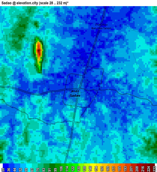
Below is the Elevation map of Sadao, which displays elevation range with different colors. Scale of the first map is from 28 to 232 m (92 to 761 ft) with average elevation of 56 meters (=184 ft) [note 1]
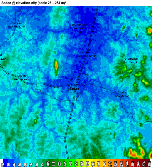
These maps also provides idea of topography and contour of this city, they are displayed at different zoom levels. More info about maps, scale and edge coordinates you can find below images.
| \ | Map #1 | Map #2 | Topo.Map |
| Scale [m] | 28..232 m | 26..284 m | × |
| Scale [ft] | 92..761 ft | 85..932 ft | × |
| Average | 56 m = 184 ft | 66.3 m = 218 ft | × |
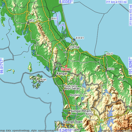
| Width | 9.71 km = 6 mi | 19.41 km = 12.1 mi | 310.6 km = 193 mi |
| Height | 9.71 km = 6 mi | 19.41 km = 12.1 mi | 310.6 km = 193 mi |
| ↑Max Latitude | 6.682479° | 6.726124° | 8.03353° |
| Latitude at center | 6.63883° | 6.63883° | 6.63883° |
| ↓Min Latitude | 6.595177° | 6.551521° | 5.24016° |
| ← Min Longitude | 100.379475° | 100.335529° | 99.01717° |
| Longitude center | 100.42342° | 100.42342° | 100.42342° |
| →Max Longitude | 100.467365° | 100.511311° | 101.82967° |
Nearby cities:
Cities around Sadao sort by population:
• Hat Yai elevation 12 m
41.5 km,  8°
8°
• Satun 15 m
39.4 km,  267°
267°
• Na Mom 38 m
38.5 km,  22°
22°
• Saba Yoi 20 m
58.4 km,  92°
92°
• Rattaphum 33 m
58.1 km,  341°
341°
• Tha Phae 13 m
52.8 km,  288°
288°
• Bang Klam 19 m
50.1 km,  358°
358°
• Chana 9 m
46.6 km,  48°
48°
• Khuan Kalong 43 m
45.1 km,  300°
300°
• Khuan Don 33 m
41.6 km, 293°
• Na Thawi 25 m
31.7 km,  68°
68°
• Khlong Hoi Khong 21 m
29.1 km,  352°
352°
Multilingual:
 En español:
Sadao elevación 50 m.
 En France:
Sadao élévation 50 m.


Sources and notes:
- [note 1] Map square and city borders are not equal. Map elevation data is calculated only from area inside that square.
- [src 1] Elevation data from geonames database provided with same terms of usage.
- [src 2] The elevation map of Sadao is generated using elevation data from NASA's 3 arcsec (90m) resolution SRTM data.
- [src 3] Base (background) map © OpenStreetMap contributors tiles are generated by Geofabrik and OpenTopoMap.
Copyright & License:
This Sadao Elevation Map is licensed under CC BY-SA. You may reuse any part from this page, if you give a proper credit by linking to this URL:
 More info on terms of use page.