Si Racha elevation
Si Racha (Chon Buri), Thailand elevation is 13 meters and Si Racha elevation in feet is 43 ft above sea level [src 1]. Si Racha is a seat of a second-order administrative division (feature code) with elevation that is 112 meters (367 ft) smaller than average city elevation in Thailand.
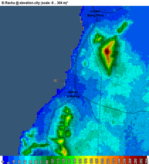
Below is the Elevation map of Si Racha, which displays elevation range with different colors. Scale of the first map is from -6 to 304 m (-20 to 997 ft) with average elevation of 42.8 meters (=140 ft) [note 1]
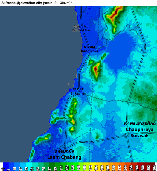
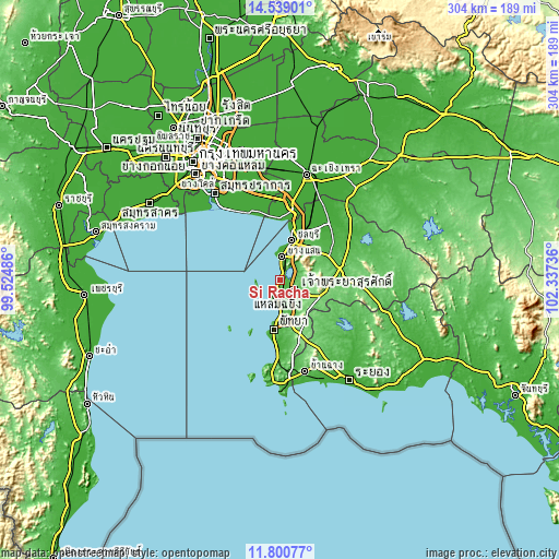
These maps also provides idea of topography and contour of this city, they are displayed at different zoom levels. More info about maps, scale and edge coordinates you can find below images.
| \ | Map #1 | Map #2 | Topo.Map |
| Scale [m] | -6..304 m | -9..304 m | × |
| Scale [ft] | -20..997 ft | -30..997 ft | × |
| Average | 42.8 m = 140 ft | 41.8 m = 137 ft | × |
| Width | 9.52 km = 5.9 mi | 19.03 km = 11.8 mi | 304.5 km = 189.2 mi |
| Height | 9.52 km = 5.9 mi | 19.03 km = 11.8 mi | 304.5 km = 189.2 mi |
| ↑Max Latitude | 13.216505° | 13.259283° | 14.53901° |
| Latitude at center | 13.17372° | 13.17372° | 13.17372° |
| ↓Min Latitude | 13.130927° | 13.088127° | 11.80077° |
| ← Min Longitude | 100.887165° | 100.843219° | 99.52486° |
| Longitude center | 100.93111° | 100.93111° | 100.93111° |
| →Max Longitude | 100.975055° | 101.019001° | 102.33736° |
Nearby cities:
Cities around Si Racha sort by population:
• Chon Buri elevation 8 m
21.7 km,  15°
15°
• Pattaya 9 m
27.2 km,  190°
190°
• Bang Lamung 7 m
14.1 km,  180°
180°
• Ban Talat Bueng 42 m
13.8 km,  145°
145°
• Bang Pakong 8 m
41.6 km,  9°
9°
• Ban Bueng 67 m
24.8 km,  52°
52°
• Phanat Nikhom 12 m
40.8 km,  42°
42°
• Phan Thong 5 m
37.2 km,  28°
28°
• Ban Ko Lan 10 m
31.8 km,  209°
209°
• Pluak Daeng 60 m
38.1 km,  126°
126°
• Na Kluea 19 m
23.8 km, 188°
• Ko Si Chang 27 m
13.6 km,  265°
265°
Multilingual:
 En español:
Si Racha elevación 13 m.
 En France:
Si Racha élévation 13 m.


Sources and notes:
- [note 1] Map square and city borders are not equal. Map elevation data is calculated only from area inside that square.
- [src 1] Elevation data from geonames database provided with same terms of usage.
- [src 2] The elevation map of Si Racha is generated using elevation data from NASA's 3 arcsec (90m) resolution SRTM data.
- [src 3] Base (background) map © OpenStreetMap contributors tiles are generated by Geofabrik and OpenTopoMap.
Copyright & License:
This Si Racha Elevation Map is licensed under CC BY-SA. You may reuse any part from this page, if you give a proper credit by linking to this URL:
 More info on terms of use page.