Si Sa Ket elevation
Si Sa Ket (Sisaket), Thailand elevation is 134 meters and Si Sa Ket elevation in feet is 440 ft above sea level [src 1]. Si Sa Ket is a seat of a first-order administrative division (feature code) with elevation that is 9 meters (30 ft) bigger than average city elevation in Thailand.
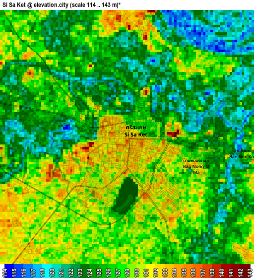
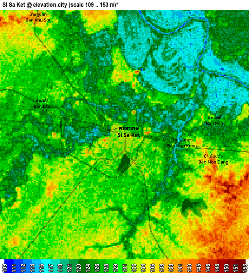
Below is the Elevation map of Si Sa Ket, which displays elevation range with different colors. Scale of the first map is from 114 to 143 m (374 to 469 ft) with average elevation of 126.5 meters (=415 ft) [note 1]
These maps also provides idea of topography and contour of this city, they are displayed at different zoom levels. More info about maps, scale and edge coordinates you can find below images.
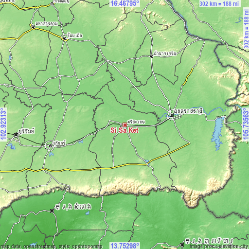
| \ | Map #1 | Map #2 | Topo.Map |
| Scale [m] | 114..143 m | 109..153 m | × |
| Scale [ft] | 374..469 ft | 358..502 ft | × |
| Average | 126.5 m = 415 ft | 128 m = 420 ft | × |
| Width | 9.43 km = 5.9 mi | 18.87 km = 11.7 mi | 301.9 km = 187.6 mi |
| Height | 9.43 km = 5.9 mi | 18.87 km = 11.7 mi | 301.9 km = 187.6 mi |
| ↑Max Latitude | 15.157231° | 15.199643° | 16.46795° |
| Latitude at center | 15.11481° | 15.11481° | 15.11481° |
| ↓Min Latitude | 15.072381° | 15.029943° | 13.75298° |
| ← Min Longitude | 104.285435° | 104.241489° | 102.92313° |
| Longitude center | 104.32938° | 104.32938° | 104.32938° |
| →Max Longitude | 104.373325° | 104.417271° | 105.73563° |
Nearby cities:
Cities around Si Sa Ket sort by population:
• Khueang Nai elevation 131 m
38.7 km,  37°
37°
• Huai Thap Than 136 m
33.1 km,  258°
258°
• Mueang Chan 141 m
31.9 km,  278°
278°
• Rasi Salai 133 m
31.7 km,  323°
323°
• Pho Si Suwan 139 m
30 km,  295°
295°
• Nam Kliang 136 m
28.7 km,  136°
136°
• Kho Wang 137 m
28.5 km,  4°
4°
• Kanthararom 137 m
26.2 km,  92°
92°
• Phayu 146 m
23.9 km,  163°
163°
• Wang Hin 139 m
21.4 km,  209°
209°
• Uthumphon Phisai 142 m
20.3 km,  268°
268°
• Yang Chum Noi 130 m
18.2 km,  23°
23°
Multilingual:
 En español:
Si Sa Ket elevación 134 m.
 En France:
Si Saket élévation 134 m.


Sources and notes:
- [note 1] Map square and city borders are not equal. Map elevation data is calculated only from area inside that square.
- [src 1] Elevation data from geonames database provided with same terms of usage.
- [src 2] The elevation map of Si Sa Ket is generated using elevation data from NASA's 3 arcsec (90m) resolution SRTM data.
- [src 3] Base (background) map © OpenStreetMap contributors tiles are generated by Geofabrik and OpenTopoMap.
Copyright & License:
This Si Sa Ket Elevation Map is licensed under CC BY-SA. You may reuse any part from this page, if you give a proper credit by linking to this URL:
 More info on terms of use page.