Suwannaphum elevation
Suwannaphum (Roi Et), Thailand elevation is 136 meters and Suwannaphum elevation in feet is 446 ft above sea level [src 1]. Suwannaphum is a seat of a second-order administrative division (feature code) with elevation that is 11 meters (36 ft) bigger than average city elevation in Thailand.
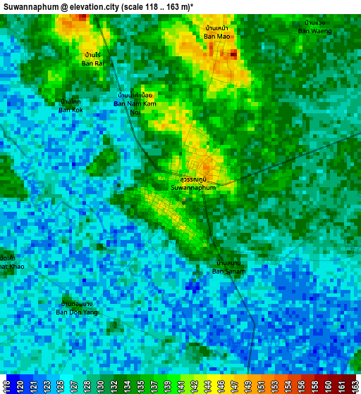
Below is the Elevation map of Suwannaphum, which displays elevation range with different colors. Scale of the first map is from 118 to 163 m (387 to 535 ft) with average elevation of 130 meters (=427 ft) [note 1]
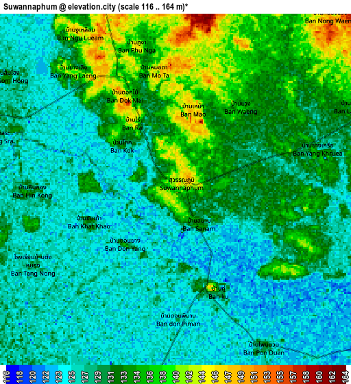
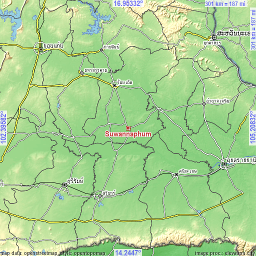
These maps also provides idea of topography and contour of this city, they are displayed at different zoom levels. More info about maps, scale and edge coordinates you can find below images.
| \ | Map #1 | Map #2 | Topo.Map |
| Scale [m] | 118..163 m | 116..164 m | × |
| Scale [ft] | 387..535 ft | 381..538 ft | × |
| Average | 130 m = 427 ft | 130.3 m = 427 ft | × |
| Width | 9.41 km = 5.8 mi | 18.82 km = 11.7 mi | 301.2 km = 187.2 mi |
| Height | 9.41 km = 5.8 mi | 18.82 km = 11.7 mi | 301.2 km = 187.2 mi |
| ↑Max Latitude | 15.645801° | 15.688114° | 16.95332° |
| Latitude at center | 15.60348° | 15.60348° | 15.60348° |
| ↓Min Latitude | 15.56115° | 15.518811° | 14.2447° |
| ← Min Longitude | 103.758125° | 103.714179° | 102.39582° |
| Longitude center | 103.80207° | 103.80207° | 103.80207° |
| →Max Longitude | 103.846015° | 103.889961° | 105.20832° |
Nearby cities:
Cities around Suwannaphum sort by population:
• Yasothon elevation 135 m
42.4 km,  60°
60°
• Kaset Wisai 145 m
24.1 km,  283°
283°
• Bueng Bun 128 m
40 km,  139°
139°
• Chaturaphak Phiman 145 m
37.6 km,  315°
315°
• Tha Tum 132 m
34.4 km,  203°
203°
• Phanom Phrai 135 m
34 km,  75°
75°
• Sila Lat 125 m
32.4 km,  116°
116°
• Rattanaburi 148 m
32.1 km,  171°
171°
• At Samat 140 m
27.9 km,  17°
17°
• Mueang Suang 157 m
25.5 km,  342°
342°
• Phon Sai 131 m
24.5 km, 121°
• Nong Hi 149 m
20.7 km,  87°
87°
Multilingual:
 En español:
Suwannaphum elevación 136 m.
 En France:
Suwannaphum élévation 136 m.
 Auf Deutsch:
Suwannaphum höhe über dem Meeresspiegel ist 136 m.

Sources and notes:
- [note 1] Map square and city borders are not equal. Map elevation data is calculated only from area inside that square.
- [src 1] Elevation data from geonames database provided with same terms of usage.
- [src 2] The elevation map of Suwannaphum is generated using elevation data from NASA's 3 arcsec (90m) resolution SRTM data.
- [src 3] Base (background) map © OpenStreetMap contributors tiles are generated by Geofabrik and OpenTopoMap.
Copyright & License:
This Suwannaphum Elevation Map is licensed under CC BY-SA. You may reuse any part from this page, if you give a proper credit by linking to this URL:
 More info on terms of use page.