Ban Nong Wua So elevation
Ban Nong Wua So (Changwat Udon Thani), Thailand elevation is 181 meters and Ban Nong Wua So elevation in feet is 594 ft above sea level [src 1]. Ban Nong Wua So is a populated place (feature code) with elevation that is 56 meters (184 ft) bigger than average city elevation in Thailand.
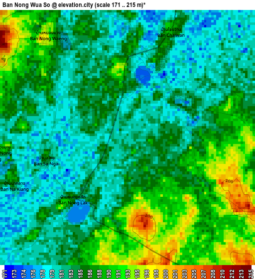
Below is the Elevation map of Ban Nong Wua So, which displays elevation range with different colors. Scale of the first map is from 171 to 215 m (561 to 705 ft) with average elevation of 185.3 meters (=608 ft) [note 1]
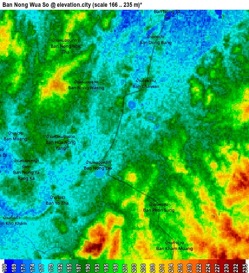
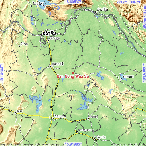
These maps also provides idea of topography and contour of this city, they are displayed at different zoom levels. More info about maps, scale and edge coordinates you can find below images.
| \ | Map #1 | Map #2 | Topo.Map |
| Scale [m] | 171..215 m | 166..235 m | × |
| Scale [ft] | 561..705 ft | 545..771 ft | × |
| Average | 185.3 m = 608 ft | 189.2 m = 621 ft | × |
| Width | 9.33 km = 5.8 mi | 18.66 km = 11.6 mi | 298.6 km = 185.5 mi |
| Height | 9.33 km = 5.8 mi | 18.66 km = 11.6 mi | 298.6 km = 185.5 mi |
| ↑Max Latitude | 17.30946° | 17.35141° | 18.60537° |
| Latitude at center | 17.2675° | 17.2675° | 17.2675° |
| ↓Min Latitude | 17.225531° | 17.183552° | 15.91985° |
| ← Min Longitude | 103.180775° | 103.136829° | 101.81847° |
| Longitude center | 103.22472° | 103.22472° | 103.22472° |
| →Max Longitude | 103.268665° | 103.312611° | 104.63097° |
Nearby cities:
Cities around Ban Nong Wua So sort by population:
• Ban Phan Don elevation 180 m
30.2 km,  242°
242°
• Sawang Daen Din 169 m
33.8 km,  46°
46°
• Tha Khantho 178 m
36.5 km,  176°
176°
• Phibun Rak 182 m
36.4 km,  330°
330°
• Si That 183 m
32.7 km, 181°
• Kumphawapi 187 m
28.4 km,  231°
231°
• Song Dao 202 m
27.7 km,  73°
73°
• Ban Na Muang 177 m
23.1 km,  261°
261°
• Thung Fon 171 m
23 km,  9°
9°
• Nong Han 173 m
16.4 km,  309°
309°
• Ku Kaeo 202 m
13.1 km,  215°
215°
• Chaiwan 185 m
3.2 km,  17°
17°
Multilingual:
 En español:
Ban Nong Wua So elevación 181 m.
 En France:
Ban Nong Wua So élévation 181 m.
 Auf Deutsch:
Ban Nong Wua So höhe über dem Meeresspiegel ist 181 m.

Sources and notes:
- [note 1] Map square and city borders are not equal. Map elevation data is calculated only from area inside that square.
- [src 1] Elevation data from geonames database provided with same terms of usage.
- [src 2] The elevation map of Ban Nong Wua So is generated using elevation data from NASA's 3 arcsec (90m) resolution SRTM data.
- [src 3] Base (background) map © OpenStreetMap contributors tiles are generated by Geofabrik and OpenTopoMap.
Copyright & License:
This Ban Nong Wua So Elevation Map is licensed under CC BY-SA. You may reuse any part from this page, if you give a proper credit by linking to this URL:
 More info on terms of use page.