Bo Phloi elevation
Bo Phloi (Kanchanaburi), Thailand elevation is 96 meters and Bo Phloi elevation in feet is 315 ft above sea level [src 1]. Bo Phloi is a seat of a second-order administrative division (feature code) with elevation that is 29 meters (95 ft) smaller than average city elevation in Thailand.
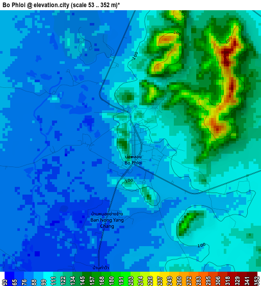
Below is the Elevation map of Bo Phloi, which displays elevation range with different colors. Scale of the first map is from 53 to 352 m (174 to 1155 ft) with average elevation of 106.3 meters (=349 ft) [note 1]
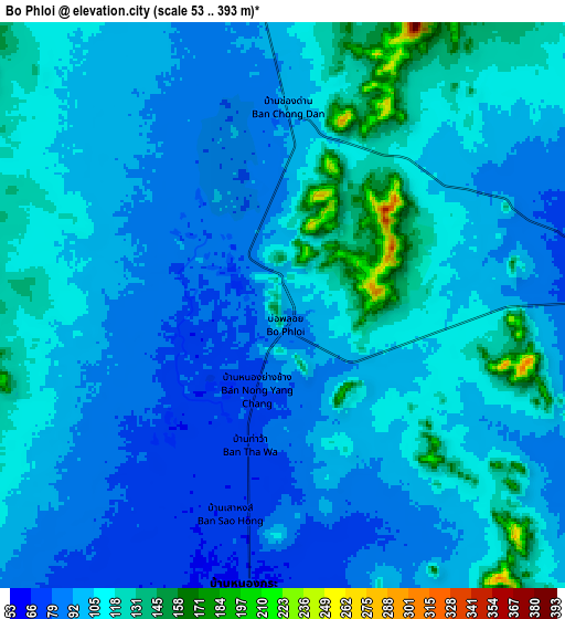
These maps also provides idea of topography and contour of this city, they are displayed at different zoom levels. More info about maps, scale and edge coordinates you can find below images.
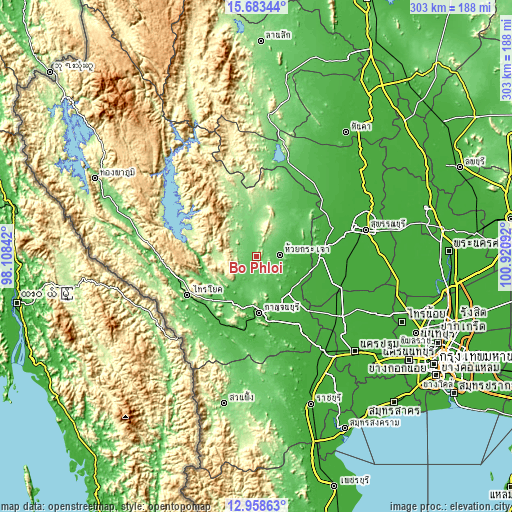
| \ | Map #1 | Map #2 | Topo.Map |
| Scale [m] | 53..352 m | 53..393 m | × |
| Scale [ft] | 174..1155 ft | 174..1289 ft | × |
| Average | 106.3 m = 349 ft | 103.9 m = 341 ft | × |
| Width | 9.47 km = 5.9 mi | 18.94 km = 11.8 mi | 303 km = 188.3 mi |
| Height | 9.47 km = 5.9 mi | 18.94 km = 11.8 mi | 303 km = 188.3 mi |
| ↑Max Latitude | 14.367745° | 14.410312° | 15.68344° |
| Latitude at center | 14.32517° | 14.32517° | 14.32517° |
| ↓Min Latitude | 14.282587° | 14.239996° | 12.95863° |
| ← Min Longitude | 99.470725° | 99.426779° | 98.10842° |
| Longitude center | 99.51467° | 99.51467° | 99.51467° |
| →Max Longitude | 99.558615° | 99.602561° | 100.92092° |
Nearby cities:
Cities around Bo Phloi sort by population:
• Kanchanaburi elevation 33 m
35.9 km,  174°
174°
• Tha Maka 15 m
54.5 km,  150°
150°
• Tha Muang 27 m
42.7 km,  161°
161°
• Phanom Thuan 19 m
29.4 km,  137°
137°
• Dan Makham Tia 66 m
53.6 km,  192°
192°
• Si Sawat 225 m
52.8 km,  305°
305°
• Tha Maka 23 m
52.5 km, 148°
• Sai Yok 58 m
46.2 km,  240°
240°
• U Thong 14 m
41.1 km,  82°
82°
• Lao Khwan 43 m
41 km,  42°
42°
• Nong Prue 139 m
32 km,  348°
348°
• Huai Krachao 69 m
16.5 km,  89°
89°
Multilingual:
 En español:
Bo Phloi elevación 96 m.
 En France:
Bo Phloi élévation 96 m.


Sources and notes:
- [note 1] Map square and city borders are not equal. Map elevation data is calculated only from area inside that square.
- [src 1] Elevation data from geonames database provided with same terms of usage.
- [src 2] The elevation map of Bo Phloi is generated using elevation data from NASA's 3 arcsec (90m) resolution SRTM data.
- [src 3] Base (background) map © OpenStreetMap contributors tiles are generated by Geofabrik and OpenTopoMap.
Copyright & License:
This Bo Phloi Elevation Map is licensed under CC BY-SA. You may reuse any part from this page, if you give a proper credit by linking to this URL:
 More info on terms of use page.