Dok Kham Tai elevation
Dok Kham Tai (Phayao), Thailand elevation is 394 meters and Dok Kham Tai elevation in feet is 1293 ft above sea level [src 1]. Dok Kham Tai is a seat of a second-order administrative division (feature code) with elevation that is 269 meters (883 ft) bigger than average city elevation in Thailand.
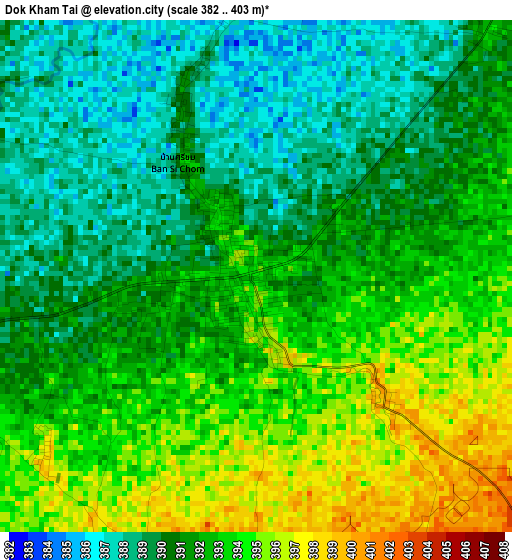
Below is the Elevation map of Dok Kham Tai, which displays elevation range with different colors. Scale of the first map is from 382 to 403 m (1253 to 1322 ft) with average elevation of 391.5 meters (=1284 ft) [note 1]
These maps also provides idea of topography and contour of this city, they are displayed at different zoom levels. More info about maps, scale and edge coordinates you can find below images.
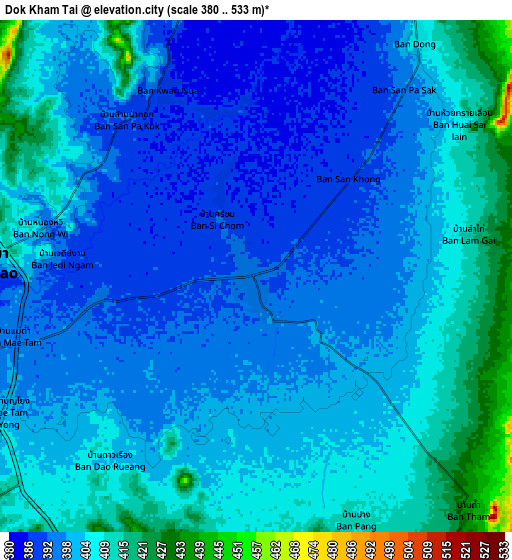
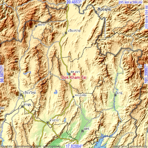
| \ | Map #1 | Map #2 | Topo.Map |
| Scale [m] | 382..403 m | 380..533 m | × |
| Scale [ft] | 1253..1322 ft | 1247..1749 ft | × |
| Average | 391.5 m = 1284 ft | 401.3 m = 1317 ft | × |
| Width | 9.23 km = 5.7 mi | 18.46 km = 11.5 mi | 295.4 km = 183.6 mi |
| Height | 9.23 km = 5.7 mi | 18.46 km = 11.5 mi | 295.4 km = 183.6 mi |
| ↑Max Latitude | 19.203925° | 19.24542° | 20.4853° |
| Latitude at center | 19.16242° | 19.16242° | 19.16242° |
| ↓Min Latitude | 19.120904° | 19.079378° | 17.82884° |
| ← Min Longitude | 99.949475° | 99.905529° | 98.58717° |
| Longitude center | 99.99342° | 99.99342° | 99.99342° |
| →Max Longitude | 100.037365° | 100.081311° | 101.39967° |
Nearby cities:
Cities around Dok Kham Tai sort by population:
• Phayao elevation 409 m
12.5 km,  285°
285°
• Pong 300 m
29.6 km,  92°
92°
• Chiang Kham 396 m
51.4 km,  38°
38°
• Pa Daet 384 m
38.1 km,  359°
359°
• Mae Chai 407 m
27.8 km,  317°
317°
• Wiang Pa Pao 544 m
55 km, 291°
• Phan 416 m
51 km,  328°
328°
• Ngao 283 m
45.1 km,  182°
182°
• Chiang Muan 275 m
44.7 km,  132°
132°
• Wang Nuea 420 m
39.3 km,  267°
267°
• Chun 402 m
24.4 km, 37°
• Phu Kam Yao 390 m
12.3 km,  348°
348°
Multilingual:
 En español:
Dok Kham Tai elevación 394 m.
 En France:
Dok Kham Tai élévation 394 m.
 Auf Deutsch:
Dok Kham Tai höhe über dem Meeresspiegel ist 394 m.

Sources and notes:
- [note 1] Map square and city borders are not equal. Map elevation data is calculated only from area inside that square.
- [src 1] Elevation data from geonames database provided with same terms of usage.
- [src 2] The elevation map of Dok Kham Tai is generated using elevation data from NASA's 3 arcsec (90m) resolution SRTM data.
- [src 3] Base (background) map © OpenStreetMap contributors tiles are generated by Geofabrik and OpenTopoMap.
Copyright & License:
This Dok Kham Tai Elevation Map is licensed under CC BY-SA. You may reuse any part from this page, if you give a proper credit by linking to this URL:
 More info on terms of use page.