Khiri Mat elevation
Khiri Mat (Sukhothai), Thailand elevation is 53 meters and Khiri Mat elevation in feet is 174 ft above sea level [src 1]. Khiri Mat is a seat of a second-order administrative division (feature code) with elevation that is 72 meters (236 ft) smaller than average city elevation in Thailand.
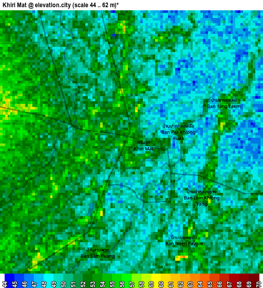
Below is the Elevation map of Khiri Mat, which displays elevation range with different colors. Scale of the first map is from 44 to 62 m (144 to 203 ft) with average elevation of 50.7 meters (=166 ft) [note 1]
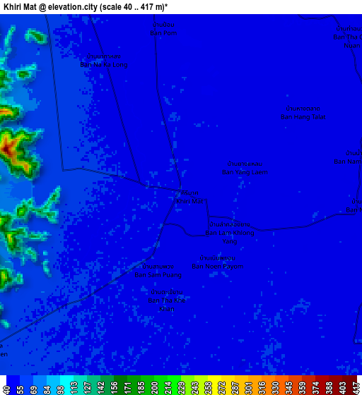
These maps also provides idea of topography and contour of this city, they are displayed at different zoom levels. More info about maps, scale and edge coordinates you can find below images.
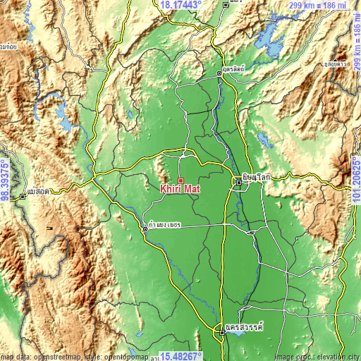
| \ | Map #1 | Map #2 | Topo.Map |
| Scale [m] | 44..62 m | 40..417 m | × |
| Scale [ft] | 144..203 ft | 131..1368 ft | × |
| Average | 50.7 m = 166 ft | 55.9 m = 183 ft | × |
| Width | 9.35 km = 5.8 mi | 18.71 km = 11.6 mi | 299.3 km = 186 mi |
| Height | 9.35 km = 5.8 mi | 18.71 km = 11.6 mi | 299.3 km = 186 mi |
| ↑Max Latitude | 16.875388° | 16.917436° | 18.17443° |
| Latitude at center | 16.83333° | 16.83333° | 16.83333° |
| ↓Min Latitude | 16.791263° | 16.749187° | 15.48267° |
| ← Min Longitude | 99.756055° | 99.712109° | 98.39375° |
| Longitude center | 99.8° | 99.8° | 99.8° |
| →Max Longitude | 99.843945° | 99.887891° | 101.20625° |
Nearby cities:
Cities around Khiri Mat sort by population:
• Phitsanulok elevation 50 m
48.8 km,  91°
91°
• Kamphaeng Phet 83 m
48.9 km,  217°
217°
• Ban Na 59 m
21.7 km,  340°
340°
• Sukhothai 53 m
19.6 km,  7°
7°
• Bang Rakam 47 m
34.8 km,  103°
103°
• Lan Krabue 58 m
26.5 km,  168°
168°
• Ban Dan Lan Hoi 87 m
30.7 km,  308°
308°
• Phrom Phiram 51 m
48.2 km,  62°
62°
• Sai Ngam 59 m
41.6 km, 166°
• Si Samrong 59 m
37.4 km, 10°
• Phran Kratai 68 m
29.2 km,  230°
230°
• Kong Krailat 46 m
23.1 km, 55°
Multilingual:
 En español:
Khiri Mat elevación 53 m.
 En France:
Khiri Mat élévation 53 m.
 Auf Deutsch:
Khiri Mat höhe über dem Meeresspiegel ist 53 m.

Sources and notes:
- [note 1] Map square and city borders are not equal. Map elevation data is calculated only from area inside that square.
- [src 1] Elevation data from geonames database provided with same terms of usage.
- [src 2] The elevation map of Khiri Mat is generated using elevation data from NASA's 3 arcsec (90m) resolution SRTM data.
- [src 3] Base (background) map © OpenStreetMap contributors tiles are generated by Geofabrik and OpenTopoMap.
Copyright & License:
This Khiri Mat Elevation Map is licensed under CC BY-SA. You may reuse any part from this page, if you give a proper credit by linking to this URL:
 More info on terms of use page.