Tha Khanon elevation
Tha Khanon (Surat Thani, Amphoe Khiri Rat Nikhom), Thailand elevation is 22 meters and Tha Khanon elevation in feet is 72 ft above sea level [src 1]. Tha Khanon is a seat of a second-order administrative division (feature code) with elevation that is 103 meters (338 ft) smaller than average city elevation in Thailand.
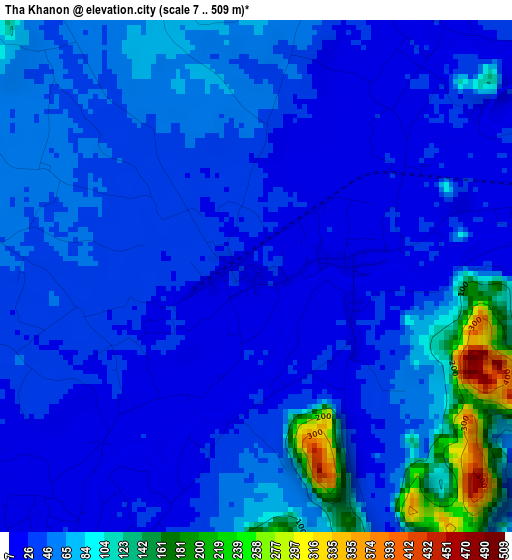
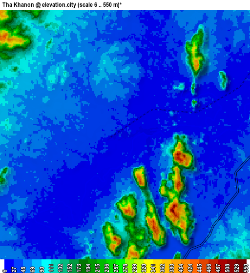
Below is the Elevation map of Tha Khanon, which displays elevation range with different colors. Scale of the first map is from 7 to 509 m (23 to 1670 ft) with average elevation of 53.8 meters (=177 ft) [note 1]
These maps also provides idea of topography and contour of this city, they are displayed at different zoom levels. More info about maps, scale and edge coordinates you can find below images.
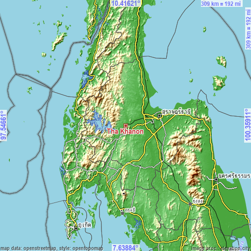
| \ | Map #1 | Map #2 | Topo.Map |
| Scale [m] | 7..509 m | 6..550 m | × |
| Scale [ft] | 23..1670 ft | 20..1804 ft | × |
| Average | 53.8 m = 177 ft | 67.1 m = 220 ft | × |
| Width | 9.65 km = 6 mi | 19.3 km = 12 mi | 308.8 km = 191.9 mi |
| Height | 9.65 km = 6 mi | 19.3 km = 12 mi | 308.8 km = 191.9 mi |
| ↑Max Latitude | 9.073598° | 9.116991° | 10.41621° |
| Latitude at center | 9.0302° | 9.0302° | 9.0302° |
| ↓Min Latitude | 8.986797° | 8.943388° | 7.63884° |
| ← Min Longitude | 98.908915° | 98.864969° | 97.54661° |
| Longitude center | 98.95286° | 98.95286° | 98.95286° |
| →Max Longitude | 98.996805° | 99.040751° | 100.35911° |
Nearby cities:
Cities around Tha Khanon sort by population:
• Surat Thani elevation 10 m
43.5 km,  73°
73°
• Tha Kham 10 m
31.9 km, 73°
• Ban Na San 40 m
51.9 km,  119°
119°
• Chaiya 11 m
47.9 km,  34°
34°
• Kanchanadit 34 m
58.8 km,  75°
75°
• Plai Phraya 66 m
56.2 km,  190°
190°
• Ban Na Doem 36 m
42.5 km,  112°
112°
• Tha Chang 9 m
37 km,  45°
45°
• Khian Sa 19 m
34.1 km,  127°
127°
• Phanom 52 m
24.9 km,  218°
218°
• Takuk Nuea 57 m
23.4 km,  6°
6°
• Ban Takhun 29 m
15.9 km,  208°
208°
Multilingual:
 En español:
Tha Khanon elevación 22 m.
 En France:
Tha Khanon élévation 22 m.
 Auf Deutsch:
Tha Khanon höhe über dem Meeresspiegel ist 22 m.

Sources and notes:
- [note 1] Map square and city borders are not equal. Map elevation data is calculated only from area inside that square.
- [src 1] Elevation data from geonames database provided with same terms of usage.
- [src 2] The elevation map of Tha Khanon is generated using elevation data from NASA's 3 arcsec (90m) resolution SRTM data.
- [src 3] Base (background) map © OpenStreetMap contributors tiles are generated by Geofabrik and OpenTopoMap.
Copyright & License:
This Tha Khanon Elevation Map is licensed under CC BY-SA. You may reuse any part from this page, if you give a proper credit by linking to this URL:
 More info on terms of use page.