Phuket elevation
Phuket, Thailand elevation is 28 meters and Phuket elevation in feet is 92 ft above sea level [src 1]. Phuket is a seat of a first-order administrative division (feature code) with elevation that is 97 meters (318 ft) smaller than average city elevation in Thailand.
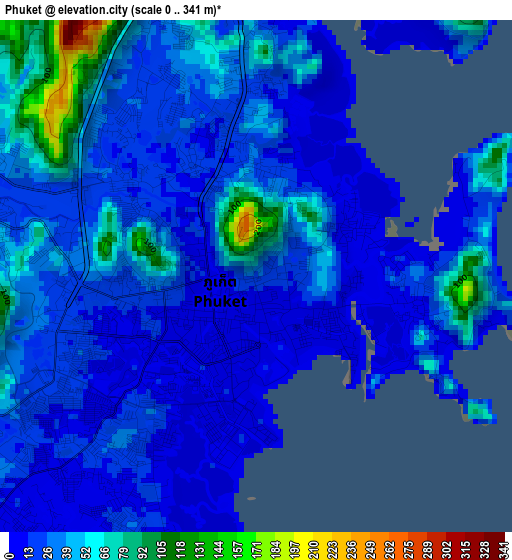
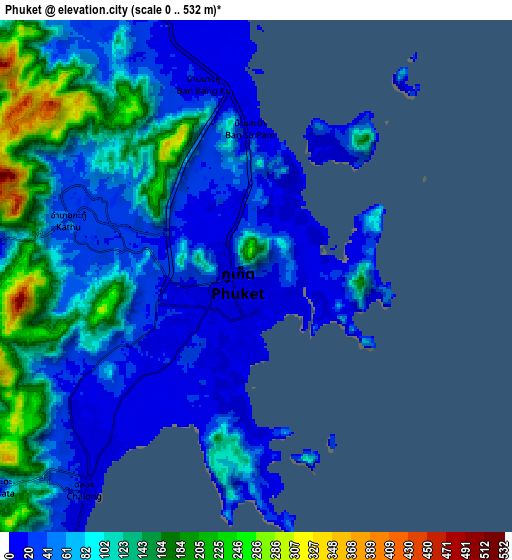
Below is the Elevation map of Phuket, which displays elevation range with different colors. Scale of the first map is from 0 to 341 m (0 to 1119 ft) with average elevation of 31.2 meters (=102 ft) [note 1]
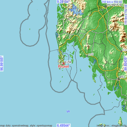
These maps also provides idea of topography and contour of this city, they are displayed at different zoom levels. More info about maps, scale and edge coordinates you can find below images.
| \ | Map #1 | Map #2 | Topo.Map |
| Scale [m] | 0..341 m | 0..532 m | × |
| Scale [ft] | 0..1119 ft | 0..1745 ft | × |
| Average | 31.2 m = 102 ft | 80.5 m = 264 ft | × |
| Width | 9.68 km = 6 mi | 19.36 km = 12 mi | 309.7 km = 192.4 mi |
| Height | 9.68 km = 6 mi | 19.36 km = 12 mi | 309.8 km = 192.5 mi |
| ↑Max Latitude | 7.934117° | 7.977639° | 9.28104° |
| Latitude at center | 7.89059° | 7.89059° | 7.89059° |
| ↓Min Latitude | 7.847058° | 7.803522° | 6.49544° |
| ← Min Longitude | 98.354155° | 98.310209° | 96.99185° |
| Longitude center | 98.3981° | 98.3981° | 98.3981° |
| →Max Longitude | 98.442045° | 98.485991° | 99.80435° |
Nearby cities:
Cities around Phuket sort by population:
• Ban Talat Yai elevation 8 m
0.7 km,  161°
161°
• Wichit 14 m
1.4 km,  264°
264°
• Kathu 36 m
7.8 km,  292°
292°
• Ban Ratsada 12 m
2.2 km,  12°
12°
• Ban Talat Nua 10 m
1.5 km,  245°
245°
• Ban Chalong 13 m
8.3 km,  231°
231°
• Patong 8 m
11.2 km,  273°
273°
• Rawai 12 m
14.7 km,  213°
213°
• Ban Ko Kaeo 42 m
5.1 km,  358°
358°
• Ban Karon 15 m
12 km, 246°
• Ban Kata 25 m
12.7 km, 232°
• Mueang Phuket 13 m
4.8 km, 230°
Multilingual:
 En español:
Phuket elevación 28 m.
 En France:
Phuket élévation 28 m.


Sources and notes:
- [note 1] Map square and city borders are not equal. Map elevation data is calculated only from area inside that square.
- [src 1] Elevation data from geonames database provided with same terms of usage.
- [src 2] The elevation map of Phuket is generated using elevation data from NASA's 3 arcsec (90m) resolution SRTM data.
- [src 3] Base (background) map © OpenStreetMap contributors tiles are generated by Geofabrik and OpenTopoMap.
Copyright & License:
This Phuket Elevation Map is licensed under CC BY-SA. You may reuse any part from this page, if you give a proper credit by linking to this URL:
 More info on terms of use page.