Bang Bon elevation
Bang Bon (Bangkok), Thailand elevation is 3 meters and Bang Bon elevation in feet is 10 ft above sea level [src 1]. Bang Bon is a seat of a second-order administrative division (feature code) with elevation that is 122 meters (400 ft) smaller than average city elevation in Thailand.
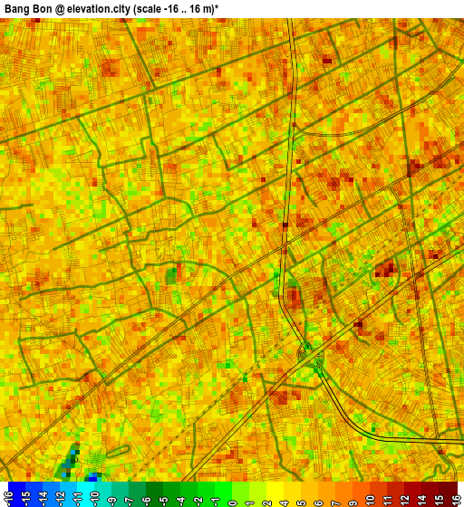
Below is the Elevation map of Bang Bon, which displays elevation range with different colors. Scale of the first map is from -16 to 16 m (-52 to 52 ft) with average elevation of 4.9 meters (=16 ft) [note 1]
These maps also provides idea of topography and contour of this city, they are displayed at different zoom levels. More info about maps, scale and edge coordinates you can find below images.
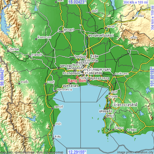
| \ | Map #1 | Topo.Map |
| Scale [m] | -16..16 m | × |
| Scale [ft] | -52..52 ft | × |
| Average | 4.9 m = 16 ft | × |
| Width | 9.5 km = 5.9 mi | 303.8 km = 188.8 mi |
| Height | 9.5 km = 5.9 mi | 303.9 km = 188.8 mi |
| ↑Max Latitude | 13.704548° | 15.02423° |
| Latitude at center | 13.66185° | 13.66185° |
| ↓Min Latitude | 13.619144° | 12.29155° |
| ← Min Longitude | 100.351725° | 98.98942° |
| Longitude center | 100.39567° | 100.39567° |
| →Max Longitude | 100.439615° | 101.80192° |
Nearby cities:
Cities around Bang Bon sort by population:
• Taling Chan elevation 8 m
14.4 km,  27°
27°
• Bangkok Noi 9 m
14.3 km,  38°
38°
• Thung Khru 6 m
12.9 km,  106°
106°
• Rat Burana 7 m
12.1 km,  79°
79°
• Bang Kho Laem 8 m
12 km,  73°
73°
• Thon Buri 7 m
11.9 km,  53°
53°
• Bangkok Yai 9 m
11 km, 51°
• Chom Thong 6 m
9.7 km, 79°
• Phasi Charoen 8 m
7.4 km, 37°
• Nong Khaem 8 m
7 km,  313°
313°
• Bang Khun Thian 8 m
4.2 km,  88°
88°
• Bang Khae 7 m
3.6 km,  19°
19°
Multilingual:
 En español:
Bang Bon elevación 3 m.
 En France:
Bang Bon élévation 3 m.


Sources and notes:
- [note 1] Map square and city borders are not equal. Map elevation data is calculated only from area inside that square.
- [src 1] Elevation data from geonames database provided with same terms of usage.
- [src 2] The elevation map of Bang Bon is generated using elevation data from NASA's 3 arcsec (90m) resolution SRTM data.
- [src 3] Base (background) map © OpenStreetMap contributors tiles are generated by Geofabrik and OpenTopoMap.
Copyright & License:
This Bang Bon Elevation Map is licensed under CC BY-SA. You may reuse any part from this page, if you give a proper credit by linking to this URL:
 More info on terms of use page.