Nong Yasai elevation
Nong Yasai (Suphan Buri), Thailand elevation is 32 meters and Nong Yasai elevation in feet is 105 ft above sea level [src 1]. Nong Yasai is a seat of a second-order administrative division (feature code) with elevation that is 93 meters (305 ft) smaller than average city elevation in Thailand.
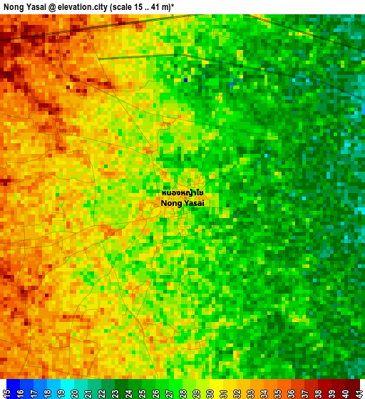
Below is the Elevation map of Nong Yasai, which displays elevation range with different colors. Scale of the first map is from 15 to 41 m (49 to 135 ft) with average elevation of 28.2 meters (=93 ft) [note 1]
These maps also provides idea of topography and contour of this city, they are displayed at different zoom levels. More info about maps, scale and edge coordinates you can find below images.
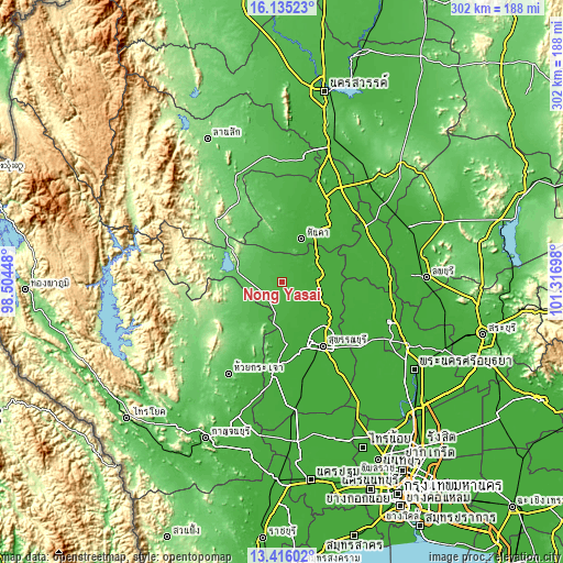
| \ | Map #1 | Topo.Map |
| Scale [m] | 15..41 m | × |
| Scale [ft] | 49..135 ft | × |
| Average | 28.2 m = 93 ft | × |
| Width | 9.45 km = 5.9 mi | 302.3 km = 187.8 mi |
| Height | 9.45 km = 5.9 mi | 302.4 km = 187.9 mi |
| ↑Max Latitude | 14.822367° | 16.13523° |
| Latitude at center | 14.77988° | 14.77988° |
| ↓Min Latitude | 14.737385° | 13.41602° |
| ← Min Longitude | 99.866785° | 98.50448° |
| Longitude center | 99.91073° | 99.91073° |
| →Max Longitude | 99.954675° | 101.31698° |
Nearby cities:
Cities around Nong Yasai sort by population:
• Doembang Nangbuat elevation 16 m
21.2 km,  73°
73°
• Ban Sam Chuk 13 m
20.3 km,  101°
101°
• Sankhaburi 22 m
40.1 km,  42°
42°
• Sam Ko 13 m
38.3 km,  120°
120°
• Si Prachan 15 m
30.8 km,  125°
125°
• Lao Khwan 43 m
25.2 km,  215°
215°
• Hankha 20 m
25 km,  26°
26°
• Dan Chang 85 m
23.9 km,  286°
286°
• Doem Bang Nang Buat 17 m
21.7 km, 67°
• Don Chedi 15 m
20 km,  143°
143°
• Sam Chuk 13 m
19.4 km, 97°
• Noen Kham 29 m
19.2 km,  9°
9°
Multilingual:
 En español:
Nong Yasai elevación 32 m.
 En France:
Nong Yasai élévation 32 m.
 Auf Deutsch:
Nong Yasai höhe über dem Meeresspiegel ist 32 m.

Sources and notes:
- [note 1] Map square and city borders are not equal. Map elevation data is calculated only from area inside that square.
- [src 1] Elevation data from geonames database provided with same terms of usage.
- [src 2] The elevation map of Nong Yasai is generated using elevation data from NASA's 3 arcsec (90m) resolution SRTM data.
- [src 3] Base (background) map © OpenStreetMap contributors tiles are generated by Geofabrik and OpenTopoMap.
Copyright & License:
This Nong Yasai Elevation Map is licensed under CC BY-SA. You may reuse any part from this page, if you give a proper credit by linking to this URL:
 More info on terms of use page.