Tabligbo elevation
Tabligbo (Maritime), Togo elevation is 33 meters and Tabligbo elevation in feet is 108 ft above sea level [src 1]. Tabligbo is a populated place (feature code) with elevation that is 234 meters (768 ft) smaller than average city elevation in Togo.
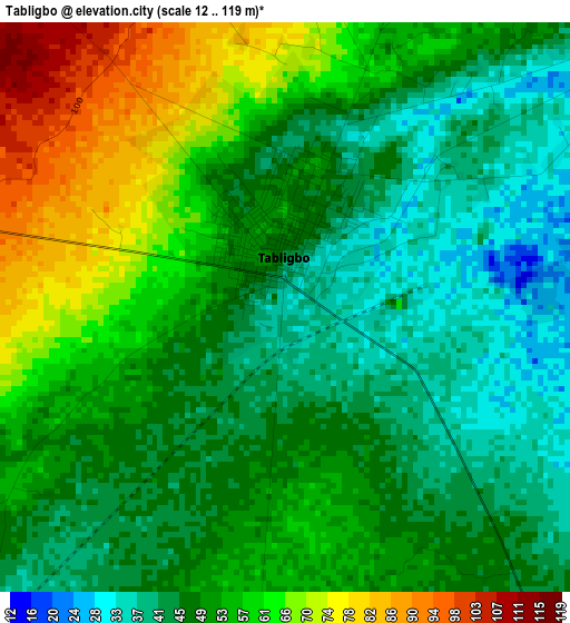
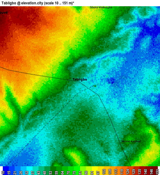
Below is the Elevation map of Tabligbo, which displays elevation range with different colors. Scale of the first map is from 12 to 119 m (39 to 390 ft) with average elevation of 51.9 meters (=170 ft) [note 1]
These maps also provides idea of topography and contour of this city, they are displayed at different zoom levels. More info about maps, scale and edge coordinates you can find below images.
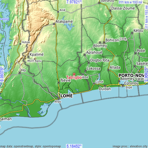
| \ | Map #1 | Map #2 | Topo.Map |
| Scale [m] | 12..119 m | 10..151 m | × |
| Scale [ft] | 39..390 ft | 33..495 ft | × |
| Average | 51.9 m = 170 ft | 62.4 m = 205 ft | × |
| Width | 9.71 km = 6 mi | 19.42 km = 12.1 mi | 310.6 km = 193 mi |
| Height | 9.71 km = 6 mi | 19.42 km = 12.1 mi | 310.7 km = 193.1 mi |
| ↑Max Latitude | 6.626984° | 6.670633° | 7.97821° |
| Latitude at center | 6.58333° | 6.58333° | 6.58333° |
| ↓Min Latitude | 6.539673° | 6.496011° | 5.18452° |
| ← Min Longitude | 1.456055° | 1.412109° | 0.09375° |
| Longitude center | 1.5° | 1.5° | 1.5° |
| →Max Longitude | 1.543945° | 1.587891° | 2.90625° |
Nearby cities:
Cities around Tabligbo sort by population:
• Lomé elevation 64 m
59.2 km,  211°
211°
• Sokodé 402 m
269.9 km,  351°
351°
• Atakpamé 361 m
113.1 km,  339°
339°
• Kpalimé 225 m
102 km,  290°
290°
• Tsévié 97 m
36.2 km,  241°
241°
• Aného 5 m
40.8 km,  165°
165°
• Tchamba 356 m
272.6 km,  358°
358°
• Badou 278 m
149.1 km,  318°
318°
• Notsé 142 m
54.9 km, 317°
• Sotouboua 380 m
227.4 km, 345°
• Vogan 37 m
28 km, 172°
• Amlamé 324 m
118.5 km,  326°
326°
Multilingual:
 En español:
Tabligbo elevación 33 m.
 En France:
Tabligbo élévation 33 m.


Sources and notes:
- [note 1] Map square and city borders are not equal. Map elevation data is calculated only from area inside that square.
- [src 1] Elevation data from geonames database provided with same terms of usage.
- [src 2] The elevation map of Tabligbo is generated using elevation data from NASA's 3 arcsec (90m) resolution SRTM data.
- [src 3] Base (background) map © OpenStreetMap contributors tiles are generated by Geofabrik and OpenTopoMap.
Copyright & License:
This Tabligbo Elevation Map is licensed under CC BY-SA. You may reuse any part from this page, if you give a proper credit by linking to this URL:
 More info on terms of use page.