Al Ḩasakah elevation
Al Ḩasakah (Al-Hasakah), Syria elevation is 305 meters and Al Ḩasakah elevation in feet is 1001 ft above sea level [src 1]. Al Ḩasakah is a seat of a first-order administrative division (feature code) with elevation that is 224 meters (735 ft) smaller than average city elevation in Syria.
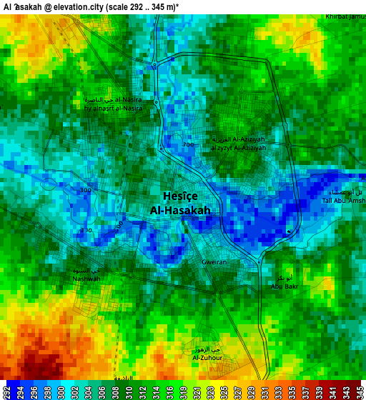
Below is the Elevation map of Al Ḩasakah, which displays elevation range with different colors. Scale of the first map is from 292 to 345 m (958 to 1132 ft) with average elevation of 310.9 meters (=1020 ft) [note 1]
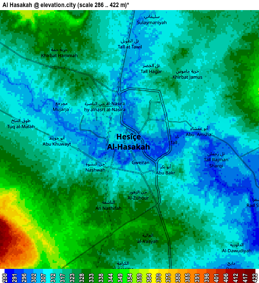
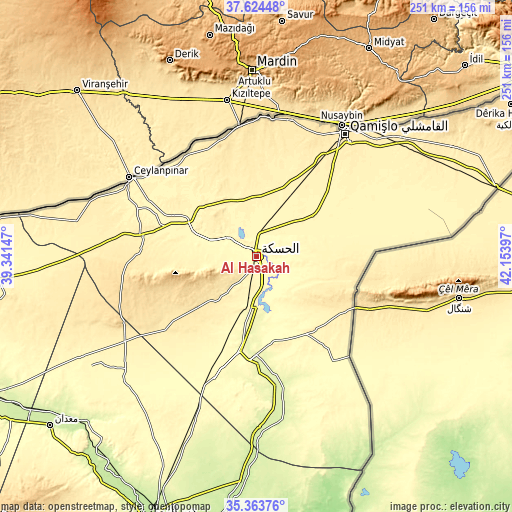
These maps also provides idea of topography and contour of this city, they are displayed at different zoom levels. More info about maps, scale and edge coordinates you can find below images.
| \ | Map #1 | Map #2 | Topo.Map |
| Scale [m] | 292..345 m | 286..422 m | × |
| Scale [ft] | 958..1132 ft | 938..1385 ft | × |
| Average | 310.9 m = 1020 ft | 320 m = 1050 ft | × |
| Width | 7.86 km = 4.9 mi | 15.71 km = 9.8 mi | 251.4 km = 156.2 mi |
| Height | 7.86 km = 4.9 mi | 15.71 km = 9.8 mi | 251.4 km = 156.2 mi |
| ↑Max Latitude | 36.537687° | 36.572987° | 37.62448° |
| Latitude at center | 36.50237° | 36.50237° | 36.50237° |
| ↓Min Latitude | 36.467037° | 36.431688° | 35.36376° |
| ← Min Longitude | 40.703775° | 40.659829° | 39.34147° |
| Longitude center | 40.74772° | 40.74772° | 40.74772° |
| →Max Longitude | 40.791665° | 40.835611° | 42.15397° |
Nearby cities:
Cities around Al Ḩasakah sort by population:
• Ad Darbāsīyah elevation 484 m
64 km,  352°
352°
• Al Qaḩţānīyah 400 m
92.1 km,  50°
50°
• Markadah 237 m
84.1 km,  179°
179°
• Al Qāmishlī 454 m
74.8 km,  35°
35°
• Ra’s al ‘Ayn 359 m
71.7 km,  302°
302°
• Amude 472 m
68.9 km,  13°
13°
• Tall Ḩamīs 349 m
64.7 km,  64°
64°
• Ash Shaddādah 265 m
49.5 km, 181°
• Al Ḩawl 430 m
38.1 km,  109°
109°
• Tall Tamr 331 m
37.7 km, 296°
• Bi’r al Ḩulw al Wardīyah 341 m
33.6 km, 49°
• ‘Arīshah 271 m
30.2 km, 175°
Multilingual:
 En español:
Al Ḩasakah elevación 305 m.
 En France:
Al Ḩasakah élévation 305 m.
 Auf Deutsch:
Al Ḩasakah höhe über dem Meeresspiegel ist 305 m.

Sources and notes:
- [note 1] Map square and city borders are not equal. Map elevation data is calculated only from area inside that square.
- [src 1] Elevation data from geonames database provided with same terms of usage.
- [src 2] The elevation map of Al Ḩasakah is generated using elevation data from NASA's 3 arcsec (90m) resolution SRTM data.
- [src 3] Base (background) map © OpenStreetMap contributors tiles are generated by Geofabrik and OpenTopoMap.
Copyright & License:
This Al Ḩasakah Elevation Map is licensed under CC BY-SA. You may reuse any part from this page, if you give a proper credit by linking to this URL:
 More info on terms of use page.