Jablah elevation
Jablah (Latakia), Syria elevation is 26 meters and Jablah elevation in feet is 85 ft above sea level [src 1]. Jablah is a seat of a second-order administrative division (feature code) with elevation that is 503 meters (1650 ft) smaller than average city elevation in Syria.
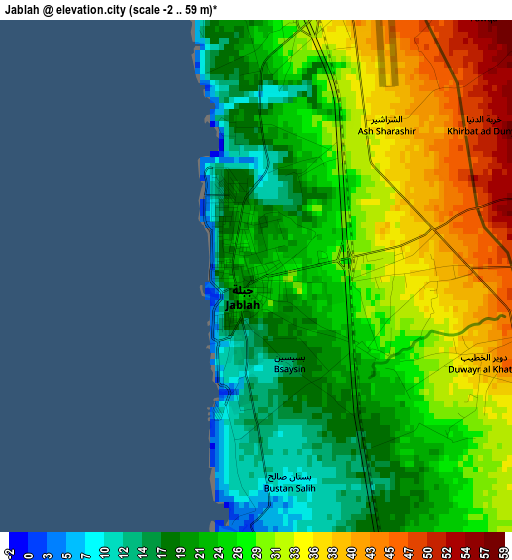
Below is the Elevation map of Jablah, which displays elevation range with different colors. Scale of the first map is from -2 to 59 m (-7 to 194 ft) with average elevation of 27 meters (=89 ft) [note 1]
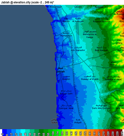
These maps also provides idea of topography and contour of this city, they are displayed at different zoom levels. More info about maps, scale and edge coordinates you can find below images.
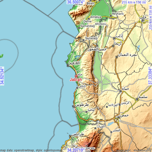
| \ | Map #1 | Map #2 | Topo.Map |
| Scale [m] | -2..59 m | -2..249 m | × |
| Scale [ft] | -7..194 ft | -7..817 ft | × |
| Average | 27 m = 89 ft | 55.9 m = 183 ft | × |
| Width | 7.97 km = 5 mi | 15.94 km = 9.9 mi | 255 km = 158.4 mi |
| Height | 7.97 km = 5 mi | 15.94 km = 9.9 mi | 255 km = 158.4 mi |
| ↑Max Latitude | 35.39794° | 35.433754° | 36.50074° |
| Latitude at center | 35.36211° | 35.36211° | 35.36211° |
| ↓Min Latitude | 35.326264° | 35.290402° | 34.20719° |
| ← Min Longitude | 35.883645° | 35.839699° | 34.52134° |
| Longitude center | 35.92759° | 35.92759° | 35.92759° |
| →Max Longitude | 35.971535° | 36.015481° | 37.33384° |
Nearby cities:
Cities around Jablah sort by population:
• Latakia elevation 29 m
22.6 km,  326°
326°
• Bāniyās 31 m
20.1 km,  174°
174°
• Al Muzayri‘ah 467 m
22.9 km,  34°
34°
• Al ‘Annāzah 548 m
22.4 km,  145°
145°
• Ḩarf al Musaytirah 751 m
19 km,  81°
81°
• Bayt Yāshūţ 425 m
18 km,  108°
108°
• Al Hinādī 73 m
17.5 km,  343°
343°
• Al Fākhūrah 234 m
16.9 km, 26°
• ‘Ayn ash Sharqīyah 427 m
16 km,  102°
102°
• Al Qardāḩah 325 m
15.9 km,  48°
48°
• Al Quţaylibīyah 166 m
11.2 km,  134°
134°
• ‘Ayn Shiqāq 236 m
10 km,  68°
68°
Multilingual:
 En español:
Jablah elevación 26 m.
 En France:
Jablah élévation 26 m.


Sources and notes:
- [note 1] Map square and city borders are not equal. Map elevation data is calculated only from area inside that square.
- [src 1] Elevation data from geonames database provided with same terms of usage.
- [src 2] The elevation map of Jablah is generated using elevation data from NASA's 3 arcsec (90m) resolution SRTM data.
- [src 3] Base (background) map © OpenStreetMap contributors tiles are generated by Geofabrik and OpenTopoMap.
Copyright & License:
This Jablah Elevation Map is licensed under CC BY-SA. You may reuse any part from this page, if you give a proper credit by linking to this URL:
 More info on terms of use page.