Tallkalakh elevation
Tallkalakh (Homs), Syria elevation is 288 meters and Tallkalakh elevation in feet is 945 ft above sea level [src 1]. Tallkalakh is a seat of a second-order administrative division (feature code) with elevation that is 241 meters (791 ft) smaller than average city elevation in Syria.
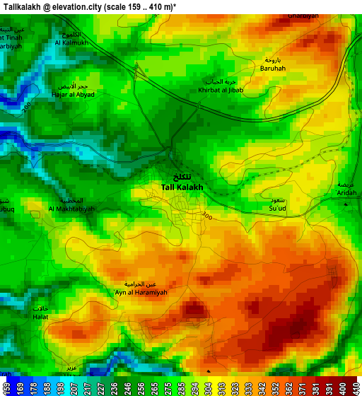
Below is the Elevation map of Tallkalakh, which displays elevation range with different colors. Scale of the first map is from 159 to 410 m (522 to 1345 ft) with average elevation of 293 meters (=961 ft) [note 1]
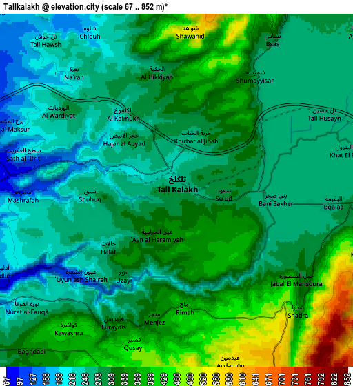
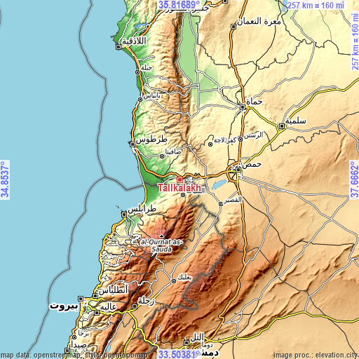
These maps also provides idea of topography and contour of this city, they are displayed at different zoom levels. More info about maps, scale and edge coordinates you can find below images.
| \ | Map #1 | Map #2 | Topo.Map |
| Scale [m] | 159..410 m | 67..852 m | × |
| Scale [ft] | 522..1345 ft | 220..2795 ft | × |
| Average | 293 m = 961 ft | 308.1 m = 1011 ft | × |
| Width | 8.04 km = 5 mi | 16.08 km = 10 mi | 257.2 km = 159.8 mi |
| Height | 8.04 km = 5 mi | 16.08 km = 10 mi | 257.2 km = 159.8 mi |
| ↑Max Latitude | 34.704555° | 34.740675° | 35.81689° |
| Latitude at center | 34.66842° | 34.66842° | 34.66842° |
| ↓Min Latitude | 34.632269° | 34.596102° | 33.50381° |
| ← Min Longitude | 36.216005° | 36.172059° | 34.8537° |
| Longitude center | 36.25995° | 36.25995° | 36.25995° |
| →Max Longitude | 36.303895° | 36.347841° | 37.6662° |
Nearby cities:
Cities around Tallkalakh sort by population:
• Satita elevation 374 m
21.4 km,  322°
322°
• Sabbah 643 m
26.2 km,  355°
355°
• Ra’s al Khashūfah 186 m
25.9 km,  312°
312°
• Mashtá al Ḩulw 502 m
22.9 km, 357°
• Aş Şafşāfah 129 m
20.3 km,  291°
291°
• Shīn 791 m
19.3 km,  50°
50°
• Al Bāriqīyah 399 m
18.1 km,  350°
350°
• Al Karīmah 51 m
16.9 km,  270°
270°
• As Sīsnīyah 166 m
16.5 km, 319°
• An Nāşirah 624 m
13.5 km,  10°
10°
• Ḩadīdah 468 m
12.6 km,  87°
87°
• Al Ḩawāsh 333 m
11.6 km,  28°
28°
Multilingual:
 En español:
Tallkalakh elevación 288 m.
 En France:
Tallkalakh élévation 288 m.
 Auf Deutsch:
Tallkalakh höhe über dem Meeresspiegel ist 288 m.

Sources and notes:
- [note 1] Map square and city borders are not equal. Map elevation data is calculated only from area inside that square.
- [src 1] Elevation data from geonames database provided with same terms of usage.
- [src 2] The elevation map of Tallkalakh is generated using elevation data from NASA's 3 arcsec (90m) resolution SRTM data.
- [src 3] Base (background) map © OpenStreetMap contributors tiles are generated by Geofabrik and OpenTopoMap.
Copyright & License:
This Tallkalakh Elevation Map is licensed under CC BY-SA. You may reuse any part from this page, if you give a proper credit by linking to this URL:
 More info on terms of use page.