Tartouss elevation
Tartouss (Tartus), Syria elevation is 20 meters and Tartouss elevation in feet is 66 ft above sea level [src 1]. Tartouss is a seat of a first-order administrative division (feature code) with elevation that is 509 meters (1670 ft) smaller than average city elevation in Syria.
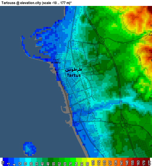
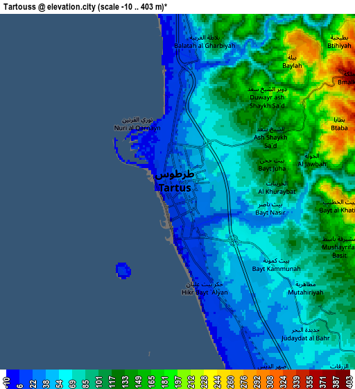
Below is the Elevation map of Tartouss, which displays elevation range with different colors. Scale of the first map is from -10 to 177 m (-33 to 581 ft) with average elevation of 45.6 meters (=150 ft) [note 1]
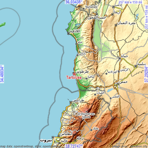
These maps also provides idea of topography and contour of this city, they are displayed at different zoom levels. More info about maps, scale and edge coordinates you can find below images.
| \ | Map #1 | Map #2 | Topo.Map |
| Scale [m] | -10..177 m | -10..403 m | × |
| Scale [ft] | -33..581 ft | -33..1322 ft | × |
| Average | 45.6 m = 150 ft | 92.9 m = 305 ft | × |
| Width | 8.02 km = 5 mi | 16.03 km = 10 mi | 256.5 km = 159.4 mi |
| Height | 8.02 km = 5 mi | 16.03 km = 10 mi | 256.5 km = 159.4 mi |
| ↑Max Latitude | 34.925059° | 34.961082° | 36.03438° |
| Latitude at center | 34.88902° | 34.88902° | 34.88902° |
| ↓Min Latitude | 34.852965° | 34.816895° | 33.72747° |
| ← Min Longitude | 35.842645° | 35.798699° | 34.48034° |
| Longitude center | 35.88659° | 35.88659° | 35.88659° |
| →Max Longitude | 35.930535° | 35.974481° | 37.29284° |
Nearby cities:
Cities around Tartouss sort by population:
• Satita elevation 374 m
22.4 km,  109°
109°
• Aş Şafşāfah 129 m
22.9 km,  138°
138°
• Junaynat Raslān 445 m
22.1 km,  78°
78°
• Ash Shaykh Badr 499 m
21.3 km,  57°
57°
• Ar Rawḑah 183 m
20.5 km,  6°
6°
• Al Ḩamīdīyah 4 m
20.3 km,  162°
162°
• Al Qamşīyah 573 m
19.9 km,  35°
35°
• Ra’s al Khashūfah 186 m
16.6 km, 114°
• Ḩimmīn 354 m
14.1 km, 84°
• Khirbat al Ma‘azzah 164 m
14 km,  132°
132°
• As Sawdā 313 m
11.5 km,  27°
27°
• Arwād 14 m
4.5 km,  214°
214°
Multilingual:
 En español:
Tartouss elevación 20 m.
 En France:
Tartous élévation 20 m.


Sources and notes:
- [note 1] Map square and city borders are not equal. Map elevation data is calculated only from area inside that square.
- [src 1] Elevation data from geonames database provided with same terms of usage.
- [src 2] The elevation map of Tartouss is generated using elevation data from NASA's 3 arcsec (90m) resolution SRTM data.
- [src 3] Base (background) map © OpenStreetMap contributors tiles are generated by Geofabrik and OpenTopoMap.
Copyright & License:
This Tartouss Elevation Map is licensed under CC BY-SA. You may reuse any part from this page, if you give a proper credit by linking to this URL:
 More info on terms of use page.