Malakal elevation
Malakal (Central Upper Nile), South Sudan elevation is 400 meters and Malakal elevation in feet is 1312 ft above sea level [src 1]. Malakal is a seat of a first-order administrative division (feature code) with elevation that is 89 meters (292 ft) smaller than average city elevation in South Sudan.
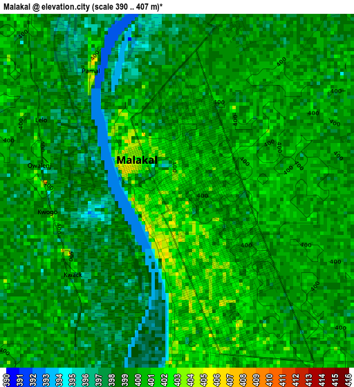
Below is the Elevation map of Malakal, which displays elevation range with different colors. Scale of the first map is from 390 to 407 m (1280 to 1335 ft) with average elevation of 399 meters (=1309 ft) [note 1]
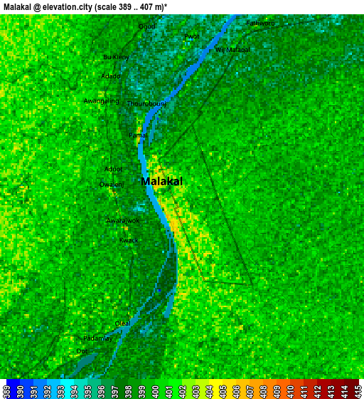
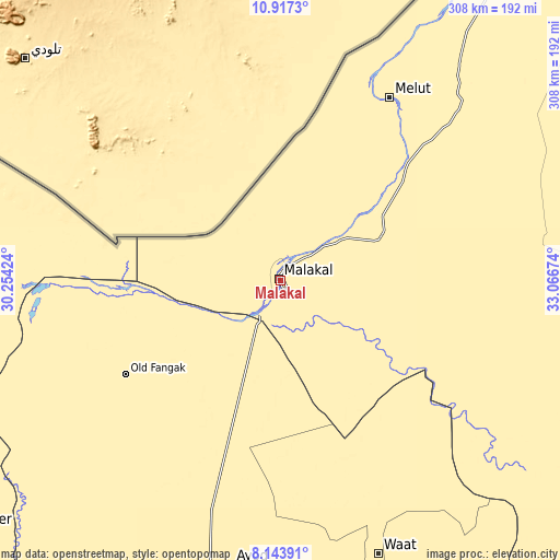
These maps also provides idea of topography and contour of this city, they are displayed at different zoom levels. More info about maps, scale and edge coordinates you can find below images.
| \ | Map #1 | Map #2 | Topo.Map |
| Scale [m] | 390..407 m | 389..407 m | × |
| Scale [ft] | 1280..1335 ft | 1276..1335 ft | × |
| Average | 399 m = 1309 ft | 398.9 m = 1309 ft | × |
| Width | 9.64 km = 6 mi | 19.28 km = 12 mi | 308.4 km = 191.6 mi |
| Height | 9.64 km = 6 mi | 19.28 km = 12 mi | 308.4 km = 191.6 mi |
| ↑Max Latitude | 9.576756° | 9.620086° | 10.9173° |
| Latitude at center | 9.53342° | 9.53342° | 9.53342° |
| ↓Min Latitude | 9.490079° | 9.446732° | 8.14391° |
| ← Min Longitude | 31.616545° | 31.572599° | 30.25424° |
| Longitude center | 31.66049° | 31.66049° | 31.66049° |
| →Max Longitude | 31.704435° | 31.748381° | 33.06674° |
Nearby cities:
Cities around Malakal sort by population:
• Leer elevation 397 m
215.8 km,  230°
230°
• Bentiu 395 m
206.6 km,  261°
261°
• Yirol 444 m
355.3 km,  201°
201°
• Pibor 422 m
344.4 km,  151°
151°
• Renk 392 m
275.7 km,  26°
26°
• Maiwut 437 m
269.1 km,  112°
112°
• Akobo 413 m
243.6 km,  142°
142°
• Pariang 412 m
188.9 km,  282°
282°
• Nasir 405 m
184.6 km,  123°
123°
• Waat 406 m
160 km,  160°
160°
• Ayod 411 m
159.4 km,  189°
189°
• Kodok 394 m
63.1 km,  51°
51°
Multilingual:
 En español:
Malakal elevación 400 m.
 En France:
Malakal élévation 400 m.


Sources and notes:
- [note 1] Map square and city borders are not equal. Map elevation data is calculated only from area inside that square.
- [src 1] Elevation data from geonames database provided with same terms of usage.
- [src 2] The elevation map of Malakal is generated using elevation data from NASA's 3 arcsec (90m) resolution SRTM data.
- [src 3] Base (background) map © OpenStreetMap contributors tiles are generated by Geofabrik and OpenTopoMap.
Copyright & License:
This Malakal Elevation Map is licensed under CC BY-SA. You may reuse any part from this page, if you give a proper credit by linking to this URL:
 More info on terms of use page.