Garoowe elevation
Garoowe (Nugaal), Somalia elevation is 465 meters and Garoowe elevation in feet is 1526 ft above sea level [src 1]. Garoowe is a seat of a first-order administrative division (feature code) with elevation that is 175 meters (574 ft) bigger than average city elevation in Somalia.
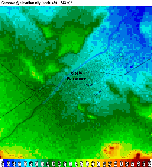
Below is the Elevation map of Garoowe, which displays elevation range with different colors. Scale of the first map is from 439 to 543 m (1440 to 1781 ft) with average elevation of 470.8 meters (=1545 ft) [note 1]
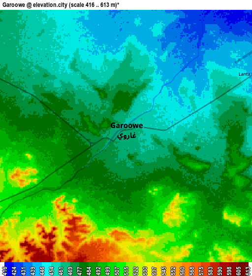
These maps also provides idea of topography and contour of this city, they are displayed at different zoom levels. More info about maps, scale and edge coordinates you can find below images.
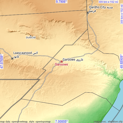
| \ | Map #1 | Map #2 | Topo.Map |
| Scale [m] | 439..543 m | 416..613 m | × |
| Scale [ft] | 1440..1781 ft | 1365..2011 ft | × |
| Average | 470.8 m = 1545 ft | 480.3 m = 1576 ft | × |
| Width | 9.67 km = 6 mi | 19.34 km = 12 mi | 309.3 km = 192.2 mi |
| Height | 9.67 km = 6 mi | 19.34 km = 12 mi | 309.4 km = 192.3 mi |
| ↑Max Latitude | 8.445541° | 8.489008° | 9.7906° |
| Latitude at center | 8.40207° | 8.40207° | 8.40207° |
| ↓Min Latitude | 8.358594° | 8.315113° | 7.00855° |
| ← Min Longitude | 48.438895° | 48.394949° | 47.07659° |
| Longitude center | 48.48284° | 48.48284° | 48.48284° |
| →Max Longitude | 48.526785° | 48.570731° | 49.88909° |
Nearby cities:
Cities around Garoowe sort by population:
• Burao elevation 1041 m
347 km,  291°
291°
• Bosaso 12 m
329.5 km,  13°
13°
• Gaalkacyo 288 m
215.4 km,  212°
212°
• Laascaanood 692 m
123.8 km,  273°
273°
• Ceerigaabo 1786 m
274.9 km,  333°
333°
• Eyl 47 m
154.1 km,  107°
107°
• Bandarbeyla 29 m
283.2 km,  64°
64°
• Hobyo 5 m
339.3 km,  179°
179°
• Las Khorey 6 m
308.2 km,  354°
354°
• Iskushuban 278 m
283.7 km,  42°
42°
• Ceek 865 m
349.8 km,  280°
280°
• Adado 311 m
324.6 km,  219°
219°
Multilingual:
 En español:
Garoowe elevación 465 m.
 En France:
Garowe élévation 465 m.


Sources and notes:
- [note 1] Map square and city borders are not equal. Map elevation data is calculated only from area inside that square.
- [src 1] Elevation data from geonames database provided with same terms of usage.
- [src 2] The elevation map of Garoowe is generated using elevation data from NASA's 3 arcsec (90m) resolution SRTM data.
- [src 3] Base (background) map © OpenStreetMap contributors tiles are generated by Geofabrik and OpenTopoMap.
Copyright & License:
This Garoowe Elevation Map is licensed under CC BY-SA. You may reuse any part from this page, if you give a proper credit by linking to this URL:
 More info on terms of use page.