Matam elevation
Matam, Senegal elevation is 22 meters and Matam elevation in feet is 72 ft above sea level [src 1]. Matam is a seat of a first-order administrative division (feature code) with elevation that is 3 meters (10 ft) smaller than average city elevation in Senegal.
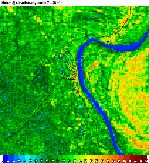
Below is the Elevation map of Matam, which displays elevation range with different colors. Scale of the first map is from 7 to 28 m (23 to 92 ft) with average elevation of 17.3 meters (=57 ft) [note 1]
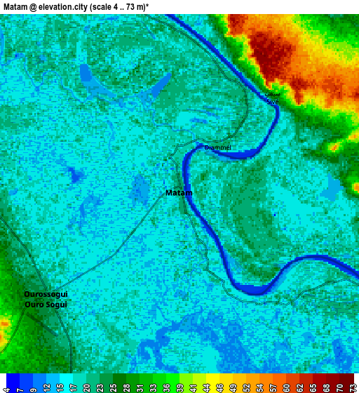
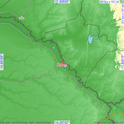
These maps also provides idea of topography and contour of this city, they are displayed at different zoom levels. More info about maps, scale and edge coordinates you can find below images.
| \ | Map #1 | Map #2 | Topo.Map |
| Scale [m] | 7..28 m | 4..73 m | × |
| Scale [ft] | 23..92 ft | 13..240 ft | × |
| Average | 17.3 m = 57 ft | 21.1 m = 69 ft | × |
| Width | 9.41 km = 5.8 mi | 18.82 km = 11.7 mi | 301.1 km = 187.1 mi |
| Height | 9.41 km = 5.8 mi | 18.82 km = 11.7 mi | 301.1 km = 187.1 mi |
| ↑Max Latitude | 15.698181° | 15.740482° | 17.00535° |
| Latitude at center | 15.65587° | 15.65587° | 15.65587° |
| ↓Min Latitude | 15.613551° | 15.571223° | 14.29742° |
| ← Min Longitude | -13.299385° | -13.343331° | -14.66169° |
| Longitude center | -13.25544° | -13.25544° | -13.25544° |
| →Max Longitude | -13.211495° | -13.167549° | -11.84919° |
Nearby cities:
Cities around Matam sort by population:
• Tambacounda elevation 32 m
214.2 km,  191°
191°
• Dara 41 m
240.8 km,  261°
261°
• Ndibène Dahra 42 m
240.7 km, 261°
• Ouro Sogui 26 m
9.1 km,  232°
232°
• Ndioum 18 m
176.6 km,  302°
302°
• Kanel 24 m
20.1 km,  155°
155°
• Waoundé 24 m
60.2 km,  136°
136°
• Diawara 29 m
103.9 km,  132°
132°
• Goléré 18 m
112.4 km,  306°
306°
• Sémé 42 m
61.2 km,  147°
147°
• Polel Diaoubé 36 m
51.2 km, 147°
• Ranérou 33 m
85.9 km,  242°
242°
Multilingual:
 En español:
Matam elevación 22 m.
 En France:
Matam élévation 22 m.


Sources and notes:
- [note 1] Map square and city borders are not equal. Map elevation data is calculated only from area inside that square.
- [src 1] Elevation data from geonames database provided with same terms of usage.
- [src 2] The elevation map of Matam is generated using elevation data from NASA's 3 arcsec (90m) resolution SRTM data.
- [src 3] Base (background) map © OpenStreetMap contributors tiles are generated by Geofabrik and OpenTopoMap.
Copyright & License:
This Matam Elevation Map is licensed under CC BY-SA. You may reuse any part from this page, if you give a proper credit by linking to this URL:
 More info on terms of use page.