Wima elevation
Wima (Eastern Province), Sierra Leone elevation is 306 meters and Wima elevation in feet is 1004 ft above sea level [src 1]. Wima is a populated place (feature code) with elevation that is 149 meters (489 ft) bigger than average city elevation in Sierra Leone.
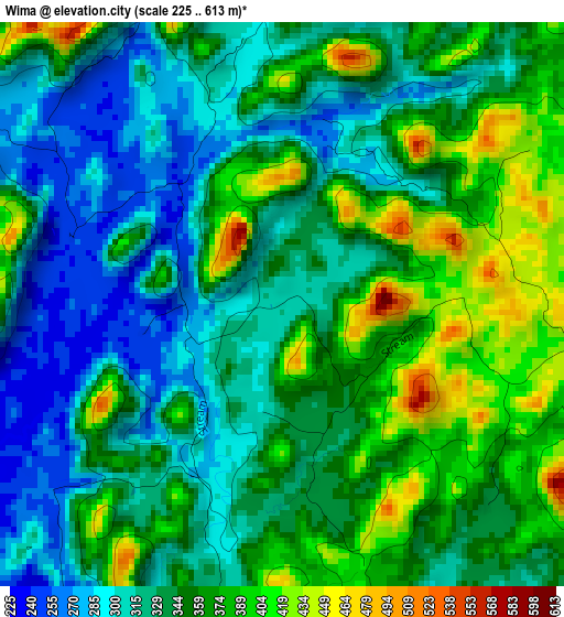
Below is the Elevation map of Wima, which displays elevation range with different colors. Scale of the first map is from 225 to 613 m (738 to 2011 ft) with average elevation of 344.8 meters (=1131 ft) [note 1]
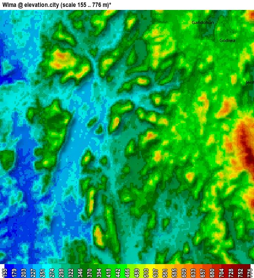
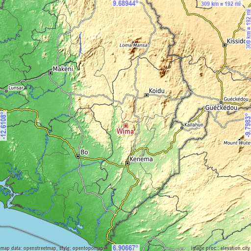
These maps also provides idea of topography and contour of this city, they are displayed at different zoom levels. More info about maps, scale and edge coordinates you can find below images.
| \ | Map #1 | Map #2 | Topo.Map |
| Scale [m] | 225..613 m | 155..776 m | × |
| Scale [ft] | 738..2011 ft | 509..2546 ft | × |
| Average | 344.8 m = 1131 ft | 353.3 m = 1159 ft | × |
| Width | 9.67 km = 6 mi | 19.34 km = 12 mi | 309.4 km = 192.3 mi |
| Height | 9.67 km = 6 mi | 19.34 km = 12 mi | 309.4 km = 192.3 mi |
| ↑Max Latitude | 8.344003° | 8.38748° | 9.68944° |
| Latitude at center | 8.30052° | 8.30052° | 8.30052° |
| ↓Min Latitude | 8.257033° | 8.21354° | 6.90667° |
| ← Min Longitude | -11.248495° | -11.292441° | -12.6108° |
| Longitude center | -11.20455° | -11.20455° | -11.20455° |
| →Max Longitude | -11.160605° | -11.116659° | -9.7983° |
Nearby cities:
Cities around Wima sort by population:
• Koidu elevation 381 m
46 km,  33°
33°
• Segbwema 180 m
44 km,  140°
140°
• Panguma 309 m
15.1 km,  148°
148°
• Barma 148 m
14.9 km,  291°
291°
• Boajibu 150 m
19.5 km,  229°
229°
• Bunumbu 188 m
40 km,  110°
110°
• Motema 405 m
40.8 km, 31°
• Hangha 176 m
40.7 km,  170°
170°
• Palima 253 m
38.9 km,  238°
238°
• Tefeya 333 m
44.9 km,  358°
358°
• Giehun 405 m
33.4 km, 32°
• Simbakoro 403 m
40.9 km, 31°
Multilingual:
 En español:
Wima elevación 306 m.
 En France:
Wima élévation 306 m.


Sources and notes:
- [note 1] Map square and city borders are not equal. Map elevation data is calculated only from area inside that square.
- [src 1] Elevation data from geonames database provided with same terms of usage.
- [src 2] The elevation map of Wima is generated using elevation data from NASA's 3 arcsec (90m) resolution SRTM data.
- [src 3] Base (background) map © OpenStreetMap contributors tiles are generated by Geofabrik and OpenTopoMap.
Copyright & License:
This Wima Elevation Map is licensed under CC BY-SA. You may reuse any part from this page, if you give a proper credit by linking to this URL:
 More info on terms of use page.