Sečovce elevation
Sečovce (Košický kraj, Okres Trebišov), Slovakia elevation is 125 meters and Sečovce elevation in feet is 410 ft above sea level [src 1]. Sečovce is a populated place (feature code) with elevation that is 195 meters (640 ft) smaller than average city elevation in Slovakia.
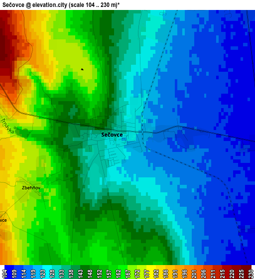
Below is the Elevation map of Sečovce, which displays elevation range with different colors. Scale of the first map is from 104 to 230 m (341 to 755 ft) with average elevation of 139.8 meters (=459 ft) [note 1]
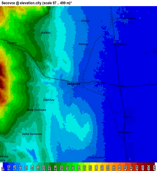
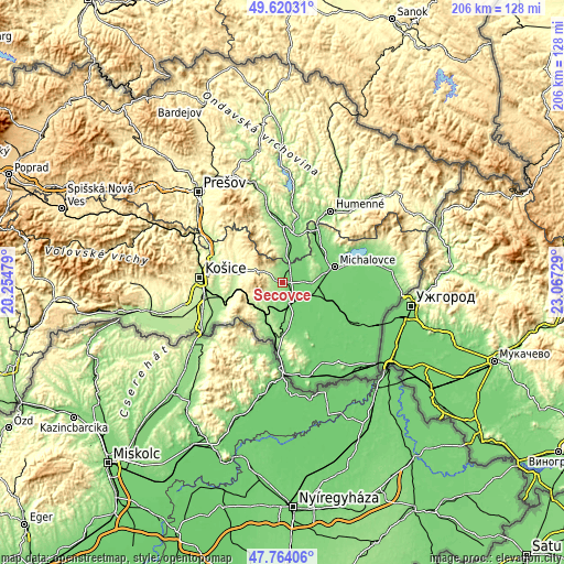
These maps also provides idea of topography and contour of this city, they are displayed at different zoom levels. More info about maps, scale and edge coordinates you can find below images.
| \ | Map #1 | Map #2 | Topo.Map |
| Scale [m] | 104..230 m | 97..499 m | × |
| Scale [ft] | 341..755 ft | 318..1637 ft | × |
| Average | 139.8 m = 459 ft | 159.9 m = 525 ft | × |
| Width | 6.45 km = 4 mi | 12.9 km = 8 mi | 206.4 km = 128.3 mi |
| Height | 6.45 km = 4 mi | 12.9 km = 8 mi | 206.4 km = 128.3 mi |
| ↑Max Latitude | 48.729735° | 48.758714° | 49.62031° |
| Latitude at center | 48.70074° | 48.70074° | 48.70074° |
| ↓Min Latitude | 48.671728° | 48.642699° | 47.76406° |
| ← Min Longitude | 21.617095° | 21.573149° | 20.25479° |
| Longitude center | 21.66104° | 21.66104° | 21.66104° |
| →Max Longitude | 21.704985° | 21.748931° | 23.06729° |
Nearby cities:
Cities around Sečovce sort by population:
• Košice elevation 205 m
29.6 km,  272°
272°
• Prešov 247 m
45.5 km,  316°
316°
• Michalovce 111 m
19.9 km,  72°
72°
• Humenné 152 m
32.2 km,  35°
35°
• Vranov nad Topľou 131 m
20.9 km,  4°
4°
• Trebišov 105 m
9.1 km,  151°
151°
• Chlmec 213 m
29 km, 44°
• Sobrance 118 m
38.5 km,  82°
82°
• Čierna nad Tisou 102 m
44.6 km,  135°
135°
• Strážske 134 m
23.1 km,  33°
33°
• Vinné 150 m
25.5 km,  61°
61°
• Kavečany 454 m
34.4 km,  284°
284°
Multilingual:
 En español:
Sečovce elevación 125 m.
 En France:
Sečovce élévation 125 m.


Sources and notes:
- [note 1] Map square and city borders are not equal. Map elevation data is calculated only from area inside that square.
- [src 1] Elevation data from geonames database provided with same terms of usage.
- [src 2] The elevation map of Sečovce is generated using elevation data from NASA's 3 arcsec (90m) resolution SRTM data.
- [src 3] Base (background) map © OpenStreetMap contributors tiles are generated by Geofabrik and OpenTopoMap.
Copyright & License:
This Sečovce Elevation Map is licensed under CC BY-SA. You may reuse any part from this page, if you give a proper credit by linking to this URL:
 More info on terms of use page.